FAQ: Chasing the Southwestern Monsoon

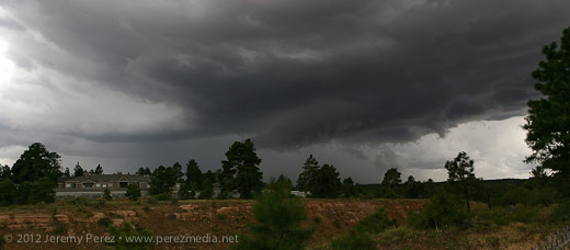
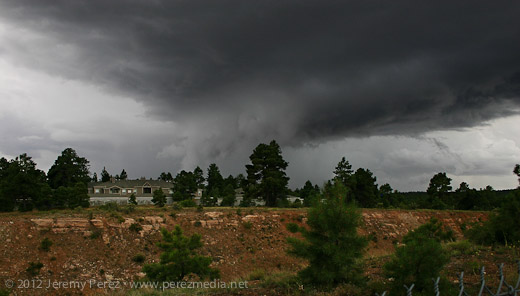
The synoptic monsoon began Sunday in Arizona in the mountains and along the Mexican border. This evening a vigorous haboob rolled about fifty miles in an hour from near Casa Grande up to the northeast Phoenix valley. In Fountain Hills a half hour ago visibilities were less than 1/4 mile with straight-out flag steady winds of 35+ mph. The parent storm remained well south of the metropolitan area -- typical of these early-season storms.
 
I will be looking for good lightning spots 7/28/11 to 7/31/11 in the Tucson area.
 
An impressive lightning display last night across the south-Phoenix metro area. I didn't get a chance to get out and photograph due to other obligations. Tonight could be a rare repeat. My camera is charged and I'm hoping that I can get some shots in.
 
It's been 11 months since the last post here.

GFS has been persistently forecasting a return of monsoon flow the June 23-26 time frame. NWS has picked up on it and is including mention of it in their forecasts and notified spotters of a potentially active weekend. Looks like all of S Central and SE Arizona should see some form of convective action. I'm optimistically waiting for NAM to confirm the forecast.
 
For monsoon lightning chasers:

http://www.atmo.arizona.edu/index.php?section=weather&id=wrf

This is a fairly high resolution (1.8km) set of forecasts covering Arizona. The run initialized at 12z with GFS data is typically the most accurate. WRF at such a high resolution usually does better than the parent NAM or GFS or RUC forecasts, since it handles convection and topography explicitly at higher resolution. It will be interesting to see how it does vs the RR this year.

Sweet. Thanks for the link! I'll be checking it out over the next couple days to see how it performs. Looks like the deep flow is getting pushed into next week (6Z GFS).
 
Our U of A models indicate a decent chance of strong thunderstorm outflow/haboob traveling generally northwest from Tucson towards Phoenix this afternoon.
 
Our U of A models indicate a decent chance of strong thunderstorm outflow/haboob traveling generally northwest from Tucson towards Phoenix this afternoon.

No dust in West Phx Metro--thankfully. Looks like the flow is fairly low-grade and I don't have much hope for any "chase" or photographic opportunities.
 
Ya, our WRF runs didn't do so well on this one, after resolving some of the previous haboobs fairly well. This time storms were triggered in about the right place and about the right time, but they were significantly smaller with weaker downdrafts than forecast. So it wasnt a complete miss... but still not good...
 
Ya, our WRF runs didn't do so well on this one, after resolving some of the previous haboobs fairly well. This time storms were triggered in about the right place and about the right time, but they were significantly smaller with weaker downdrafts than forecast. So it wasnt a complete miss... but still not good...

That said, I love the site and what you are doing with ultra high resolution forecasting. Keep up the good work.
 
GFS and NAM are aligned today for a classic monsoon forecast. Storms should fire on the rim this afternoon and track southwestward into the lower deserts. The UA high resolution model isn't forecasting any dramatic outflow, so the risk for a major haboob is low. This is unfortunate for the Doppler on Wheels which happens to be patrolling the desert this week.

The monsoonal flow is staying strong through Saturday, so hopefully one of these days results in some dramatic desert thunderstorms in my neck of the valley.

One more thing. The GFS is potentially wishcasting and sending a Pacific tropical system into AZ in the July 18-20 time frame. This bears watching and could be a trigger for significant rainfall and storms.
 
LOL, you're right Ed. The GFS has gone hurricane happy, predicting about one TS spinup per week in the Eastern Pacific.
While Aridzona often benefits from remnant moisture, we haven't enjoyed a formal Tropical Storm since Nora in the mid 90s (I think).
I'd be thrilled if we got a proper 'hurricane' this year! :)
 
7/11/12 was a big night around Scottsdale. Lots of lightning, rain. How is everyone's Monsoon going so far?
http://www.youtube.com/watch?v=rFaXhd74WUk&sns=em

Here is one I enjoyed shooting in 2010...for train+monsoon lovers only.
http://www.youtube.com/watch?v=GpvqOgj_ajU&sns=em
Vail, AZ is a town east of Tucson with great Monsoon flow and multiple freight train tracks. The trains go fast, blowing their horns. The storms are much more reliable than Phoenix (except the last few days, great action in Phoenix!)
 
Last edited by a moderator:
We had some nice, strong convection develop over Flagstaff yesterday (July 24, 2012). Instability was approaching 1000 j/kg and maybe a measly 15 kt of shear at best. Still, as I was heading back into the office after grabbing some lunch a little before noon, I noticed one of the developing cells was sporting a pretty sturdy lowering. I dropped lunch off at my desk and checked FGZ radar. The cell actually appeared to have a weak and probably very transient couplet associated with it. So I grabbed my camera and went out to get some photos.

For a pop-up monsoon storm, it was actually a real beauty. The lowering I saw earlier was still in place, and based on its position in the rain free base and relative to the precipitation core, I'd hazard to call it a brief wall cloud (non-supercellular). Further up along the back of the rain free base, an inflow tail was pressed up against the core.

Panorama taken facing southwest from Flagstaff--storm motion is to the east. Large image
img20120724_IMG_7977-Edit_md.jpg


As it moved eastward, it started to gust out and the inflow lowering mushed out and became shelfy--and probably looked pretty menacing to anyone closer to the base.

Low hanging shelf cloud develops. Large Image
img20120724_IMG_7987-Edit_md.jpg


Yesterday's midday storms caused some localized flooding in town, and generated a few funnel cloud reports. I can imagine the raggy shelf on this storm being the source of some of those reports.

This link will take you to a 1.6 Mb animated GIF image of the storm
 
Back
Top