Silver Lining Tours vans rolled in Kansas

Status
Not open for further replies.
I would like to think this is the same way the SLT drivers or anyone would approach it, despite hearing anything along the lines of “Keep going and don’t stop” on a video. I take outburst like that to mean, “We need to keep moving and can’t afford to wait at traffic lights (but obviously we are not going to just blow through without even looking).”

I'm guessing he was referring to the Joplin video. My take on that is the tour drivers were talking aloud about other cars, that were oblivious to the threat, ahead of them on Ridgeline road. But whatever they were talking about, Silver Lining put themselves in that situation as, according to one of the tour drivers in that video, they were attempting to get south of the approaching tornado located to their southwest.
 
You misunderstood what I said or I did not convey it clearly. We were not hit by the earlier start of the EF-2. We were driving east on 56 and watched the rotation from the west of the forming tornado and watched it go across the highway and head NE. With the wind shifts on the road ahead of us we technically could have been in the outer circulation of the start of a tornado and that is what was said to my chase partner. It was moving away from us and never did we get in front or in it. We stopped and once it passed 56 we continued to 59 where we watched the EF4 cross the road about ½ mile in front of us. We were never in danger and I think I played that storm correctly.

According to NWS survey the tornado was on the ground for 2 miles before it crossed 56 so it wasn't just forming.

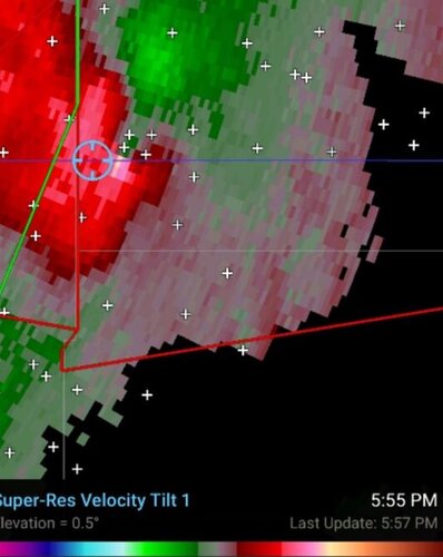
You said, "I can confirm the rotation at this location as we drove in this exact spot on 56 highway and had winds shift around us from south then to north. I told the people in the vehicle that we had just drove through a weak tornado."

Then later you said, "I can tell you the rotation was on us and that we saw nothing as for as structure or tornado features. Winds south then north that is about all we could see. Very HP."

You had "people" in the car with you. I really dont care where or how you chase but approaching a rain wrapped tornado from the rear is a dangerous spot. No visibility, only the wind and radar to tell you where you are. You would have to factor in the tilt of the meso according to how for you were from the radar site. How do you know where the tornado is under those few pixels? Not to mention the time delay on the data getting to you. There was no way to tell exactly where the tornado was, an EFO at this point lucky for you, and you got in it. I honestly don't care how you and your people chase as I never have the desire to burden other chasers with the same burden of caution I place on myself. But you are critical of SLT and yet you were in a very dangerous spot.

I decided earlier in this thread to withdraw everything I said regarding risk levels concerning driving through RFD. Because I finally figured out when people were saying RFD they where meaning driving across or into the bears cage from the outside. And I did not want new chasers reading what i said and thinking that was a low risk thing to do.

New chasers are reading what you say about handling this storm correctly. Yet you got in it. In fact most chasers would consider driving blind into a bears cage from the rear more dangerous than getting in the notch because if rain is heavy you have no visibility. You overshot the tornado as it came at you from the SW. My main reason for saying any of this is if newer chasers are concerned about safety at all, this is not a correct way to approach a storm.
 
I have been doing this for a long time and know what I am doing … you were not there. I was on the cell for a long time before the tornado started. I have watched many tornadoes pass in front of me not a big deal if you are aware of what you are looking at. If you look at the two minute old radar image we were safe and I could tell where the tornado was and it was at least a 1/4 mile in front of us. We could not see a funnel on the ground just wind shifts so that is why I said we could not see anything. It did not mean we were wrapped in rain and blind. @Skip Talbot has my video and he can tell you I could see just fine … the road is visible for at least a ¼ mile.

Again you were not there and are only guessing and I am done with this conversation. This situation is totally different than waiting for a tornado to come to you.
 

Attachments

  • Radar.jpg
    Radar.jpg
    46.7 KB · Views: 0
One example on KCTV Kansas City at 5:52 p.m. (about 10 minutes before we were hit in the area covered by the warning): “What makes this storm so incredibly dangerous right now is that you just can’t see it. It’s completely camouflaged [by rain].” Residents were urged to take shelter.

I look forward to further analysis by chasers, but shouldn’t a highly-experienced storm chasing tour operator responsible for the lives and safety of tour guests (and who boasts of state-of-the-art weather data technology) know – or be expected to know – at least as much as anyone with a TV, radio or news app? If so, it’s hard to see how driving into that mess can be regarded as “reasonable.”
[/QUOTE]
"STOP WATCHING TELEVISION WHILE CHASING"!
It's against the law in Kansas.
 
I hope you guys can realize how much anguish it causes me to potentially contest the understanding and actions of people in this community that I greatly respect, people who have been sharing their knowledge decades before I was even around. This stuff keeps me up at night. I could just keep quiet and not get involved, but I believe that there are literally lives on the line here. It would be immoral not to say something.

On a meteorological level, at no point did I indicate that any mesocyclones in the area southwest of Lawrence on May 28 were moving "southeastward" (not sure where Skip got that impression). On NWS Topeka radar images and from the tornado tracks I surveyed (even walking into some wooded areas), the two mesocyclones involved were both moving toward the east-northeast.

There's also been some assertion that the large EF3/EF4 tornado on May 28 came from the same mesocyclone that crossed into Douglas County KS southeast of Overbrook, and that the mesocyclone visible west of Lone Star Lake around 6:00 pm CDT was only "inflow" to the occluded meso wrapped up in rain to its south. Storm-relative velocity and other images below show that's not the case, where _new_ inflow velocities, convergence, and meso formation are evident _north_ of the original meso, causing the original meso (and small tornado) to interact and merge with the new and intensifying meso.

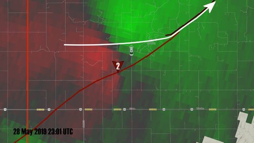
Thanks to Jon for correcting me here. I totally misremembered the plots he posted on his blog. Before Jon responded here, I had made my own plots of the high velocity areas to the north of the EF2 and SLT, and came up with a similar track direction for this developing part of the storm referred to as the "new" or "primary meso" (white line).

north meso track.jpg

I want to make sure I get this right before I publish a video on this. So I went back and redid everything I had for the evolution of the storm, analyzed the velocity data again, and replotted the storm's track.

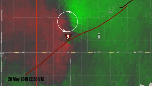
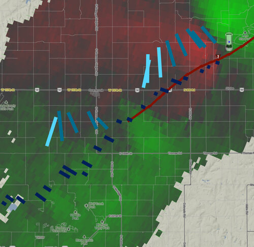
Chasers in the area were focused on an area of higher velocity, north of the ongoing (yet unknown by most) EF2. There is a rotation signature here:
north meso.jpg

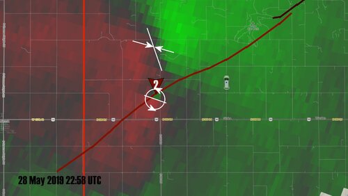
However, if you look at the orientation of the inbounds and outbounds you can see there is a convergence signature here too:
convergence.jpg
The inbounds and outbounds aren't oriented parallel to the radar beam, and this region starts out nearly perpendicular to the radial indicating strong convergence.


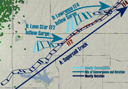
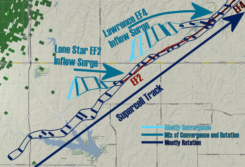
I plotted the orientation of the inbounds and outbounds on KTWX storm relative velocity for thirty or so scans from 22:28 to 23:11 UTC, about 20 minutes prior to the start of the impacting EF2 to a few minutes into the start of the EF4.

supercell track.jpg

There are a couple patterns that really stand out here:
A. There was a continuous, nearly linear track of rotation from southwest to northeast that existed well before the tornadoes, and both tornadoes closely followed this linear track.
B. Prior to each tornado there was an area of strong convergence to the north of this rotation track line. The convergence signature became a mix of rotation and convergence signature, and then mostly focused rotation as it appears to get "pulled in" or merges into this southwest to northeast track line. The tornadoes develop at about the time of these mergers.

My interpretation of what this means:
A is the track of the main supercell updraft or primary mesocyclone, and the supercell is cycling along this line.
B represents an inflow surge into the next supercell cycle, likely convergence on an inflow band, that is curling (yes with rotation) into A. Once this converging and rotating inflow surge becomes rooted to the updraft represented by A, a significant tornado spins up.

It's interesting to see that there was a velocity couplet due west of the start of the EF2 track, just like there were couplets west of the Lawrence EF4. It's as if the circulation is arriving on the inflow band, and the tornado is hooking left around the back rim of the mesocyclone as it's developing before settling into the center and being carried off to the northeast by the parent updraft.

Calling this the track of the primary, tornadic mesocyclone can be misleading or even dangerous from a storm chasing perspective.
north meso track.jpg
It makes it appear as if this is a distinctly different part of the storm, largely disconnected from what is happening with the EF2. SLT and other chasers are actively trying to stay south of this track line, which turned out to be a critical mistake. However, without the track of the EF2 here, it looks as if this would be the correct thing to do. It's important to remember that the velocity is not necessarily showing the tornado producing structure of the storm, but instead the winds flowing into and around the storm. Dangerous misinterpretations of the radar are possible here, which is why chasers shouldn't be relying o such data for their safety.

Instead, I think it's better to think of the primary tornadic mesocyclone track like this, even if there are distinctly different mesocyclone cycles on this track:
linear track.jpg
Why? Because there is not only a continuous track of rotation along this line, but there is continuous physical structure along this line. The chaser can see this visually in the form of the RFD gust front and Bear's Cage region, which is maintained along this line. That visual identification is most important here in chase making decisions.

It's also readily apparent on the reflectivity. The end of the HP hook exhibits a commahead circulation, the head of the comma I'm interpreting as roughly corresponding to the supercell's main updraft, the tail of the comma as the flanking line updrafts. The storm maintains this commahead along the above linear track. Both tornadoes appear to be rooted to the center of it where the commahead curls in on itself:


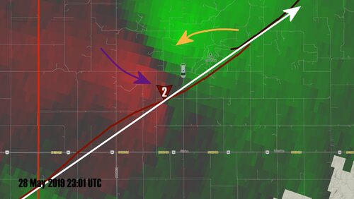
SLT is no longer south of the mesocyclone in the above velocity plot. They've crossed its path, and have effectively made it into the storm's inflow notch, before turning around and crossing it again. To their northwest there are areas of strong converging rear flank downdraft (purple arrow) and surging inflow (yellow arrow).

Focused rotation arriving along the inflow band into the rear flank gust front is not present yet as SLT is making the decision to turn around. There is instead a broad area of rotation and convergence to the west corresponding with a surge on the storm's inflow band. This storm was like a breathing entity moving down a set of tracks. It took a deep breath before each tornado.
turnaround.jpg


So what does all of this nitty gritty detail matter in what is likely just a subjective interpretation. Do I expect chasers to come up with this in the heat of the moment on the chase? NO

Do I expect chasers to note that readily identifiable tornado producing structure is moving in a mostly straight line northeast? YES

That big RFD core/Bear's Cage is a train coming down the tracks. Get out of its way.
 

Attachments

  • supercell track.jpg
    supercell track.jpg
    542 KB · Views: 0
  • north meso.jpg
    north meso.jpg
    293.9 KB · Views: 0
There was a tornado warning and a tornado was on the ground for some time. The tornado warning was spot on for the area to be hit. And this was not the first time Roger got “too close.” There appears to be some YouTube videos and major media articles where he did something similar. Why beep a horn and speed in a van loaded with people as if you’re an emergency vehicle dispatched to a call fighting traffic? Why suggest “don’t stop for nothing” when we all know chasers have a high risk for traffic accident fatalities from crashing into someone else as in not even from a tornado but the traffic itself? Have we not learned anything? Besides getting hit by a tornado, Silver Lining Tours seems to be at high risk of a traffic accident based on numerous videos of them and news articles that described past events. Has anyone seen the videos or read the articles like the one from Joplin KSPR?

Quote: "We're not stopping. I don't care what happens. You gotta go gang, you gotta go! We're about to get wacked right here." Does not stopping mean for stop lights and stop signs too?

Quote: “Roger Hill, lead storm chaser, came over the intercom in the van saying ""Don't even stop! Just go! Go! Get the hell out of here!" This is when Matt says he thought he was going to die.”

Here we have it again… don’t even stop. To any reasonable person that means a suggestion to run stop signs and red lights. What kind of a reasonable person thinks this is a good idea with vans loaded full of people rushing around inclement weather situations? And then now we have the Douglas County, KS situation. Surprised?

Going to make this my only post here, because I really wanted to avoid this discussion. I was with Roger and SLT in Joplin, and making a judgement based upon a six-minute video you've seen on youtube is pretty silly. I've seen Roger's safety record called into question based upon Joplin so many times, and its pretty frustrating. So here are some facts:
  1. When we first pulled into Joplin, the storm that would go on to produce the tornado was not yet supercellular, let alone producing a tornado. We were not chasing it, but rather, we had stopped to get gas in town.
  2. There was no tornado warning for the storm that would go on to produce the tornado in Joplin at the time we pulled into town. There was a tornado warning for a different storm that we watched become completely undercut and posed no tornado threat to the town.
  3. Every storm we watched that day previous to the tornado-producer was massively HP and the rotation was fairly transient. We watched several storms develop, spin and cross an OFB before dying. There was no reason to believe that one wouldn't do the same.
  4. When the storm did undergo tornadogenesis, we attempted to escape. But at no point did Roger do so in a manner that would constitute breaking the law. We did not run any lights, we did not blow any stop signs. In fact, the amount of unlawful behavior I see on any one given chase by scores of other chasers today far eclipses the behavior Roger displayed that day.
  5. We were stuck in traffic in a town of 50,000 people, moving at ~35 mph moving from red light to red light, while what was very clearly a violent tornado producing mesocyclone began to move overhead. I'm not exactly sure what you think you'd do in that situation Anthony, but I promise you your reaction would likely be similar.
I won't weigh in on the rest of this discussion, but the Joplin arguments are entirely silly. You weren't there, and your knowledge of the event is entirely based upon youtube videos and news articles. I challenge any other chaser who says they would behave differently in that situation to reflect on their own chasing practices. It's really easy to sit behind a computer screen and say what you would do when you're staring down certain death.
 
Many thanks to @Skip Talbot for the recent analysis. Appreciate the hard work and update. However, just a few questions:

Chasers in the area were focused on an area of higher velocity, north of the ongoing (yet unknown by most) EF2. There is a rotation signature here:
View attachment 19493

Undeniable and 100% accurate. However, there was also a classic BWER (at that time) And In looking at past events, this would seem highly accurate and normal in regards to the BWER considering the distance, beam elevation, height etc from TWX. To me, this wasn’t a highly noticeable feature once things evolved (not something that I would look for during the “heat of battle” but it should probably be noted IMO)
Again, I’m wondering if we are getting caught up in the semantics rather than the true meteorological aspects. No matter what you call it or how you slice it, Entropy is Entropy.

...look at the orientation of the inbounds and outbounds you can see there is a convergence signature here too:
View attachment 19494
The inbounds and outbounds aren't oriented parallel to the radar beam, and this region starts out nearly perpendicular to the radial indicating strong convergence.


I plotted the orientation of the inbounds and outbounds on KTWX storm relative velocity for thirty or so scans from 22:28 to 23:11 UTC, about 20 minutes prior to the start of the impacting EF2 to a few minutes into the start of the EF4.

View attachment 19496

There are a couple patterns that really stand out here:
A. There was a continuous, nearly linear track of rotation from southwest to northeast that existed well before the tornadoes, and both tornadoes closely followed this linear track.
B. Prior to each tornado there was an area of strong convergence to the north of this rotation track line. The convergence signature became a mix of rotation and convergence signature, and then mostly focused rotation as it appears to get "pulled in" or merges into this southwest to northeast track line. The tornadoes develop at about the time of these mergers.

My interpretation of what this means:
A is the track of the main supercell updraft or primary mesocyclone, and the supercell is cycling along this line.
B represents an inflow surge into the next supercell cycle, likely convergence on an inflow band, that is curling (yes with rotation) into A. Once this converging and rotating inflow surge becomes rooted to the updraft represented by A, a significant tornado spins up.

It's interesting to see that there was a velocity couplet due west of the start of the EF2 track, just like there were couplets west of the Lawrence EF4. It's as if the circulation is arriving on the inflow band, and the tornado is hooking left around the back rim of the mesocyclone as it's developing before settling into the center and being carried off to the northeast by the parent updraft.


It makes it appear as if this is a distinctly different part of the storm, largely disconnected from what is happening with the EF2. SLT and other chasers are actively trying to stay south of this track line, which turned out to be a critical mistake. However, without the track of the EF2 here, it looks as if this would be the correct thing to do. It's important to remember that the velocity is not necessarily showing the tornado producing structure of the storm, but instead the winds flowing into and around the storm. Dangerous misinterpretations of the radar are possible here, which is why chasers shouldn't be relying o such data for their safety.

Instead, I think it's better to think of the primary tornadic mesocyclone track like this, even if there are distinctly different mesocyclone cycles on this track:
View attachment 19498
Why? Because there is not only a continuous track of rotation along this line, but there is continuous physical structure along this line. The chaser can see this visually in the form of the RFD gust front and Bear's Cage region, which is maintained along this line. That visual identification is most important here in chase making decisions.

Is there any video that you might have or be able to share that might help support the concept or CLEARLY delineates “continuous physical structure” that is “visible”?

Focused rotation arriving along the inflow band into the rear flank gust front is not present yet as SLT is making the decision to turn around.

I’m sorry, but I’m having trouble understanding the verbiage here. By saying that the “inflow is not present yet as SLT is making the decision to turn around” would indicate that there was no UDI area present. Are you referring to the “new convergence” area and associated new mesocyclone? The reason for asking is because you’ve previously highlighted and detailed the inflow regions as getting “rooted” prior to tornadogenesis and a “spin up” occurs.

I don’t know that saying, assuming or even hinting that the inflow was not present is accurate in any way and IMO completely negates previous theory/posts. I am totally confused as this is something that we apparently did not study in college.

Maybe it would help me and others if I could just to see your video analysis to understand it visually. When do you think you might have that available to us @Skip Talbot ? Just trying to understand. FYI, good job on the graphics.
 
Last edited:
Alex, have you learned anything on the extensive article posted above that provides expert analysis? You're not being honest here and nobody is making any opinion based only on a short video. There's a lot of evidence floating around online, not just radar data. You better tell those NWS meteorologists that they aren't so special "sitting behind their screens" too. Sometimes radar data gives you enough clues to make a confident decision, only if you have that expertise, I guess? I'm not sure what you're trying to do here but I'll stop you in your tracks with your own words... you mention "every storm" "massively HP" ... that's what your fellow meteorologists and storm chasers are telling you... keep your distance. Don't even play around with these storms, especially if you have van loads of people. I wonder how many times all of us need to say this before the denial and arguing stops? No legitimate meteorologist should be defending getting into a Bear's Cage in an HP supercell situation with a van load of people. I say that, but then here you are with the old "you weren't there."

You have a PhD in Atmo Science? In science, many times a scientist can render an opinion based on the body of evidence (which is overwhelming in this case and not based on a single 6-minute video but a plethora of evidence including their own statements, video, radar data, damage path, witnesses, etc.) without being there. Examples of this would include what climate was like 1,000 years ago somewhere on Earth. You weren't there? No problem, we have evidence and if you know how to interpret that evidence, you can render an educated confident opinion. Another includes the great example of a doctor coming in and testifying about a death in a court case. He or she wasn't there but can tell you how someone died based on the body evidence and their expertise. Note: BODY. Not a single 6-minute video as you wrongfully suggested everyone's analysis is based upon.....

At this point, I see no further reason to comment on the analysis that is already out there and obvious. There still seems to be a small handful of people on the wrong side of science, safety, and common sense. "Roger is a good guy" is like a broken record. We're not talking about Roger's people skills or how nice he is to hang out with according to his supporters. We're talking about the radar data, obvious, Bear's Cage, the event that lead to 12 injuries (some allegedly serious), safety, damage path, past events, witnesses, their own video, tour participants, etc.


  • We were stuck in traffic in a town of 50,000 people, moving at ~35 mph moving from red light to red light, while what was very clearly a violent tornado producing mesocyclone began to move overhead. I'm not exactly sure what you think you'd do in that situation Anthony, but I promise you your reaction would likely be similar
You can't promise me that because I wouldn't put myself in that situation WITH vans loaded full of people. I don't know what kind of experience you have but this is a really bad situation you shouldn't get yourself into with vans packed full of people in an HP situation. This is what we're trying to say. You didn't know the population or anything about an area you were chasing in ahead of time? Plan much? You don't know the speed of the storms ahead of time? You don't expect or plan for changes? You don't plan on escape routes? Vans packed full of people? I would never put myself in that situation.

If I ran a tour company and had 2 vans flip with a dozen people sent to the hospital with varying injuries, I would take some time to stop and take in what happened for a few weeks, take some time off, reflect on myself and the situation, take responsibility, learn from my mistakes, and move on to something better. That's not what appears to be happening in this situation, at least publicly in clear view. And these few people coming by thinking they are doing Roger a service by attacking the obvious, downplaying, deflecting, remaining in denial, and repeating like a parrot that "Roger is a good guy" aren't helping anything IMO.

As people have said before, I too hope you and Roger or whoever you represent learned from these "alleged" mistakes. Getting too close could have killed you all. If/when that happens, it will have an impact on the entire chase community. I really hope everyone learned from this and that the talk here pressures tour operators to increase distance/awareness and just don't play around with HP supercells anymore. People will give you the benefit of the doubt in general, but there's just too much happening in this case to downplay it or pass it off as nothing.

Alex, are you serious that after this entire thread, articles, videos, witnesses, damage paths, analysis, and more than one event you can't possibly fathom why Roger's "safety" record might be challenged? You can't understand why nearly every meteorologist practicing right now said driving into the Bear's Cage with vans packed full of people is......... bad? Seems a bit off.

You also seem to indicate this was a surprise during Joplin but then you indicated supercells existed "very HP". Was there a tornado watch? "Be alert to rapidly changing weather conditions. Severe storms can and do produce tornadoes with little to no warning." This used to be something taught to grade school kids since the 1980s. It was taught in every severe weather course as well. You would think someone with a degree in meteorology would have this thought in the back of their head more so when they are part of a tour with loads of people in vans getting close to something like this, right?

Based on numerous videos I've seen, there was one in particular where the van was beeping it's horn and someone said don't stop for anything. They were close to another HP supercell tornado I believe, vans loaded full of people. Why the need to beep a horn and say don't stop for anything if this is safe? The context is very interesting here. In rainy conditions during a tornado warning, it's not safe sometimes to try and rush through traffic that is appropreately moving slower for the inclement weather conditions (slick, less visibility, etc.). Common sense.

Gist: I would not put myself in that situation, it was unnecessary. There was ample warning as to this event before the vans drove into the tornado. This is not the first close call. The fact that the vans rolled and injuries happened means it was time for this discussion. I have been chasing for decades and would never do this with cars or vans loaded full of people. I can't believe some lawsuit hasn't already started against SLT for a variety of causes. We will have to wait in see because it takes time.

  1. As I said above, I'm not commenting on what happened with Roger this year. I'm merely stating what happened during Joplin, which you have used as evidence while making your point. Please don't put words in my mouth or make assumptions regarding my feelings about that event. I've made no assertions there, nor have I tried to refute any of the above evidence.
  2. Yes, I have a Ph.D in atmospheric science. I don't need the patronizing, "You would think someone with a degree in meteorology would have this thought in the back of their head..." crap. I don't represent anyone, nor am I employed by or affiliated with SLT. Let's get that straight now.
  3. I am not commenting on Roger as being a good guy (until now -- he is), but again, thank you for putting words in my mouth.
  4. There's a substantial difference between an argument about climate change, where we are synthesizing data from inter- and intra-model consensus, ice cores, satellite imagery, etc., etc. and you reading a few articles on the internet and watching a couple of youtube videos. Your body of evidence, no matter how much you might believe it to be, is simply not enough in this case. Yeah, those climate scientists weren't there, but the volume of data is a little different. I'm giving you a first hand accounting of something that you are purporting yourself to have knowledge about. As you said, you watched a video where someone was beeping and saying don't stop, etc. I was in that van. We stopped at every light, every stop sign. Did you ignore that part of what I wrote? You talk about what you're hearing, which is different than what actually happened. See the issue here?
  5. Tornado chasing is inherently dangerous. If you think otherwise, you're kidding yourself. As far as Joplin goes, we were getting gas. We weren't even chasing. There was no exceptional risk, there was no getting too close. Chasers stop to get gas in the middle of watches all the time. In fact, chasers often stop to do other things to. Were you out during the high risk this year? There were traffic jams in Mangum when the tornado was approaching. People stopped their cars to take pics. I assume when you're chasing while in a tornado watch you never stop?
  6. Every single chase company out there chases near HP storms. I saw it chasing on May 23rd in the TX PH for instance. The number of 15 passenger vans out there was staggering. If you think this is limited to just Roger and SLT, you're kidding yourself. If you think that this happening to Roger couldn't have happened to another chase company, again, you're kidding yourself.
  7. I totally understand theres a difference between bringing a tour van full of people into a situation like that and doing it on your own, but I sure as hell hope nobody here has ever gotten too close before. That would be pretty hypocritical, no? The number of videos we see of people doing incredibly stupid things like driving into tornado or wading into waste deep storm surge is astounding. Where's the outrage there? There was a certain chaser during Michael who literally drove his car into the ocean and had to bail into a house as the eye wall was coming ashore. I get thats one individual, but a whole lot of people thought that was pretty cool. Videos like that normalize it, they make it seem ok to do. Are you going to condemn things like that? If you're going to talk about safety, best make sure you talk about all aspects of it.
I am not here to refute the evidence provided about this event, defend or indict anyone involved. I'm merely here to tell you that you are patently incorrect regarding your assumptions and conclusions regarding Roger's actions in Joplin. At the end of the day, much like with the event this year, there's about 20 people who know exactly what went down. Everything else needs to be pieced together. When it comes to what happened in Joplin, I'm one of them. You're not.
 
Staff note
Due to frequent departures of many recent posts from the main topic of this thread (as well as some unnecessary rehashing) we are temporarily closing this thread until folks calm down and some new information arises on the progression of this event.

Update: The thread has been reopened. Please do not post unless you’re offering facts or opinions directly related to the thread topic.
 
Last edited by a moderator:
So what was Roger doing during the Lawrence, KS May 28, 2019 HP supercell "rain-wrapped" tornado event? Nearly every local storm spotter, storm chaser, helicopters, and local TV meteorologists had been saying (before it arrived) that this was rain-wrapped. I know of meteorologists that gave over 1 hour of warning for this specific cell/tornado event.

What some were saying is that the few that seem to be denying the overwhelming facts/evidence in front of them seem to be frequent customers or friends of or otherwise associated with Roger Hill. Nothing wrong with being a friend and he might be a good guy in your opinion, fine. But we are discussing the facts of this matter and historical background based on his own statements, witness statements, chaser witnesses, radar evidence, watch/warning evidence, forecast data, their own videos, and damage assessment data. There's a lot more than what was said here as far as evidence. I encourage everyone to Google and read all of these previous statements, interviews, blogs, radar stuff, expert analysis, case studies, and weigh all of the evidence, not just bits and pieces. However, it should be noted whenever there is a conflict of interest that exists, especially when attempting to provide impartial analysis in any public capacity. This is still a very valid point and universal standard that would apply in court or any science research publishment.

I would say, don't chase HP supercell tornadoes or get anywhere near them with vans packed full of people. Problem solved. In fact, ironically, that's what Roger seemed to tell the Weather Channel (see above link) in an interview from 2013. Seems like he agreed with me back then. Unfortunately May 28, 2019 happened and it needs to be a learning/safety event for all storm spotters and storm chasers. And 12 injuries is a really serious event that shouldn't be downplayed by anyone especially because they were all from a single storm chasing group that almost got killed during the Joplin event as well.

There will probably be more evidence coming out soon. I think there was another person getting ready to post a video? Skip? Looking forward to what he found interviewing tour participants and what not.

We should look at this as a safety opportunity. None of the above sounds like the best safety or situational awareness. You are very lucky to be alive, despite constantly praising Roger for saving your life in your blog. Given the recent traffic deaths, it's also really risky (forget the tornado) for vans packed full of people to rush in traffic during low visibility, slick roads, and public panic. Don't put yourself in that situation. Either way, this could have been bad.

Fast forward, May 28, 2019 happened and now there's injuries (alleged) and some were serious (alleged). I can't imagine several vans of storm chasers getting killed at once but it almost happened this year. We need to talk about this and do all we can to avoid it. There shouldn't be an argument from any legit meteorologist on this matter.

When the May 28th event first happened, Hill passed it off as a satellite tornado. Now that all of the evidence is out there will he make a public statement acknowledging what happened? It was not a satellite tornado. Will there be a correction to this? It's factually incorrect. This was another case where visibility was low because this was an HP supercell tornado. It was not a surprise, tornado watch, tornado warning, multiple reports, strong radar indications, existed for some time before they drove into it, did they miss all of this, and if not, why did they get so close? Roger said he wouldn’t take his tours towards rain-rapped tornadoes in the above article/quote from him in 2013… but then there’s this recent article:

Quote: “On May 28, we drove toward eastern Kansas. A large front was supposed to develop, and there was a possibility of a super cell. Hill predicted a large tornado and spotted the beginnings of one, a mesocyclone, to the south of our vans. We kept changing position to be in front of the turbulence and to watch the tornado formation. Heavy rain made spotting difficult.”

Link: Santa Barbara Storm Chaser Recounts a Close Call

Here we have a public acknowledgement of an HP supercell tornado event being expected and Roger purposely being positioning them in front of it with the very low visibility he “swore off” in the past because of Joplin? This event was preventable.

In the same article, it says “The van behind us was hit harder. It was picked up and carried over a fence, and its passengers were more seriously injured. Twelve of us were taken to emergency rooms. Two days later, two were still in the hospital. All others were released that night.”

Here we also have a participant refuting that there were not only minor injuries. I asked a physician friend of mine if they would keep someone in a hospital for days without any serious injury or illness. His quote “Not unless that person wants to pay cash and not be covered under insurance. The only way to stay is to be admitted formally with something significant enough to warrant a stay.” That was striking to me because it means this entire storm chasing event involves some level of dishonesty, unethical behavior, just getting too close and being unsafe IMO.

Maybe more tour participants will post unedited videos for us to watch? But what would we learn from them that we don't already know now?
 
Last edited by a moderator:
So what was Roger doing during the Lawrence, KS May 28, 2019 HP supercell "rain-wrapped" tornado event? Nearly every local storm spotter, storm chaser, helicopters, and local TV meteorologists had been saying (before it arrived) that this was rain-wrapped. I know of meteorologists that gave over 1 hour of warning for this specific cell/tornado event.

Anthony, please forgive me as I have no idea who you and am not familiar with you. I’ve never heard of you and I’ve not had the pleasure to meet you or chat with you in the last 29 years while I’ve been in the field or in the “classroom”.
But I felt the need to reply to your recent post to hopefully help you understand and clear up a few things. To answer your first question:
Simply stated: He was doing his job that he has done for 30+ years.

What some were saying is that the few that seem to be denying the overwhelming facts/evidence in front of them seem to be frequent customers or friends of or otherwise associated with Roger Hill. Nothing wrong with being a friend and he might be a good guy in your opinion, fine. But we are discussing the facts of this matter and historical background based on his own statements, witness statements, chaser witnesses, radar evidence, watch/warning evidence, forecast data, their own videos, and damage assessment data. There's a lot more than what was said here as far as evidence. I encourage everyone to Google and read all of these previous statements, interviews, blogs, radar stuff, expert analysis, case studies, and weigh all of the evidence, not just bits and pieces. However, it should be noted whenever there is a conflict of interest that exists, especially when attempting to provide impartial analysis in any public capacity. This is still a very valid point and universal standard that would apply in court or any science research publishment.

Somehow the dialog (your dialog) keeps going back to a “conflict of interest “ and “the few that seem to be denying the facts”.
I don’t believe anyone is denying facts. We are questioning because Roger is a 30+ year veteran. And if it happened to Roger - it could happen to anyone one of us. I suspect this is why ALL of us want to know how it happened. We all may not agree (obviously) but we should be respectful IMO. This shame game is getting out of hand. Even those who have voiced outrage or sit on the other side of the isle ALL want to know what exactly happened - so we can avoid it hopefully in the future. Doesn’t matter if you are a friend of Roger and Caryn Hill or not. They are human beings and should be treated as such.
As I mentioned, and explained in great detail, I have no hidden agenda here. While Roger and Caryn are friends, they are also a competing tour company. That should speak volumes.


I would say, don't chase HP supercell tornadoes or get anywhere near them with vans packed full of people. Problem solved. In fact, ironically, that's what Roger seemed to tell the Weather Channel (see above link) in an interview from 2013. Seems like he agreed with me back then. Unfortunately May 28, 2019 happened and it needs to be a learning/safety event for all storm spotters and storm chasers. And 12 injuries is a really serious event that shouldn't be downplayed by anyone especially because they were all from a single storm chasing group that almost got killed during the Joplin event as well.

I don’t believe anyone is downplaying anything. Once again, we are trying to understand it. As a tour owner myself, a meteorologist, a weather engineer and a 29 year veteran - I think I can speak for many when I say it one more time...we are trying to understand.

I drove over to Doulas County yesterday to validate what damage I could (that is still present in my own dime) Trying to get the big picture. Using 30+ year Meteorologist, Jon Davies analysis, trying to visualize the situation as it unfolded. I noted damage 3 miles west of Globe north of HWY 56 - 1/2 mile north 300 Road and East 300 Road. I do not see this damage in any DI listed. This could be RFD damage, however it does not appear to be. I was able to gain access from a landowner and found trees what should have been listed as a DI. In reviewing the data from TOP, there is a small CC drop near this location. It’s questionable but it is there.
I would highly caution you in throwing the verbiage of “the few” “friends” etc....it serves no real purpose and does little for the cause.


We should look at this as a safety opportunity.
I agree 100% and I *believe* that’s what the majority of us are trying to do, no matter what our thought process is.


We need to talk about this and do all we can to avoid it. There shouldn't be an argument from any legit meteorologist on this matter.

I also agree - but IMO it should be done with couth and without the blame game. As a meteorologist who has documented well over 500 tornadoes, 14 major hurricanes, I’d also throw EXTREME caution using the verbiage “legit meteorologist”. It is unbecoming and reeks of implications that some of us (who may not agree with the status quo) simply don’t know what we are talking about because of our thought process.

When the May 28th event first happened, Hill passed it off as a satellite tornado. Now that all of the evidence is out there will he make a public statement acknowledging what happened? It was not a satellite tornado.

The issue and question of the “satellite tornado” is WELL documented in this thread. In fact, I clearly said that “we all knew pretty quick that it wasn’t a satellite tornado”. To keep bringing this up is simply argumentative and adds no real value.
I’ve mentioned why I believe he truly *thought it was*. Which IS and was viable at the time. And if you understood storm mechanics, you should clearly be able to see the same.
With little separation between the respective mesocyclone’s and “mergers/handoffs”, small ever changing dynamics, sometimes you can get little separation between the hand off and or merger. Thus, making things even more difficult under the situation. Please see my above post regarding my interpretation of Rogers thought process.

I’m not going to respond to the other comment regarding the Joplin event as it was clear they DID NOT PUT THEMSELVES IN THAT SITUATION. They stopped to get fuel. You mention folks picking and choosing but you are cherry picking just bits and pieces of past events. And I don’t know why. No need in answering, it is rhetorical.

I asked a physician friend of mine if they would keep someone in a hospital for days without any serious injury or illness. His quote “Not unless that person wants to pay cash and not be covered under insurance. The only way to stay is to be admitted formally with something significant enough to warrant a stay.” That was striking to me because it means this entire storm chasing event involves some level of dishonesty, unethical behavior, just getting too close and being unsafe IMO.

I do not understand what value this comment has in this thread or anywhere else for that matter as it is only speculation and certainly continues to try and paint Roger/SLT Negatively... “I asked a friend of a friend” type thing. Moreover, I would HIGHLY ask the mods to make an announcement to keep this thread on track so as not to derail it.

In closing, while I agree that we all need and should learn from this, I don’t believe in the shaming, abusing, negative and downright slanderous comments regarding the Hills/SLT. Nor the hashing and rehashing.

After spending about 6 hours in Kansas yesterday looking at damage and trying to visually piece things together, It is my hope that @Skip Talbot gets his video analysis done soon. I also hope that Job Davies might post or have some additional insight. But in the meantime, can we at least stay on track and refrain from bashing? I don’t want the thread to be closed down as I truly would like to know the intricacies of that event - if for nothing else than how to be better and safer in the future.

If @Quincy Vagell and I can communicate as adults (even though we may not have the same thought process) it seems to me that we could stay away from the bashing and negativity. -LFD
 
Cutting through the verbiage in recent posts:
1.) SLT deserves criticism for downplaying the extent of the injuries. In a statement issued the day after the incident, SLT reported: “Two vans were rolled resulting in a few minor injuries.” In fact, 12 people from the 2 overturned vans were transported to the hospital with cuts, sprains, broken bones and possible concussions. I’m aware of at least 3 guests with broken bones, including a tour guest with a broken neck that required vertebrae fusion surgery. That’s not a minor injury.
2.) There’s a legitimate question about why, despite the warning signs and previous near misses, 4 vans filled with tour guests were driven 3 miles north from the relative safety of Hwy. 56 into the heart of a poor-visibility HP storm that was showing rain-wrapped circulation on radar in an area with few paved escape routes to the east. Speaking from firsthand experience, Joplin wasn’t SLT’s only close call with a rain-wrapped tornado from an HP supercell.
3.) More from SLT’s statement: “Two of our vans were not effected [sp]. With any luck at all and if there had been any more space in between the vans, there wouldn’t be a need to write this today as the small tornado would have passed in between us.” That “small” tornado was 100 yards wide – big enough to take out 2 vans. Taking 4 vans into that mess and trying to excuse it with the hypothetical possibility that the tornado might have passed in between the vans is disingenuous and ludicrous.
 
Last edited:
AnthonyJ - I'm catching up on this thread and saw your recent posts. I know many chasers and meteorologists, but oddly, have never heard of you. I have one question: What are your credentials? Would like to know more about your work. Do you have a web site or social media presence? Thanks.
 
Status
Not open for further replies.
Back
Top