Rush Hour in the South Indian Ocean

Joined
Oct 30, 2006
Messages
74
Location
Minneapolis, MN
Borrowing Chris's Meteo 7 satellite image from yesterday:

LATEST.jpg


Left to right, Favio landfalling in Mozambique, the invest just offshore of Madagascar (also in an area that has been hit hard with flooding), Gamede, and Humba.

Favio landfalled, and it appears did considerable damage as well as worsening this month's severe flooding, according to one of the many news articles this morning, which also noted, "All 600 prisoners escaped when the local jail was destroyed" in Vilanculos.

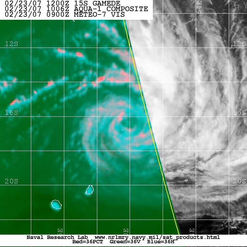
Gamede is slowly strengthening, and passed over St. Brandon earlier this morning. This is the second cyclone to pass over that reef this year, and here's something a little out of the ordinary I noted from the hourly weather reports: St Brandon was in the eye of Gamede and reported a low pressure of 957 mbar at 12Z -- but the highest winds prior to the southwestern edge of the eye passing over were only 49 kt (10-min avg...equiv to 56 kt 1-min avg). This microwave image shows that St Brandon likely slid between the areas of convection where higher winds existed (convection displays as pink). The 957 agrees well with the satellite intensity estimate, but do 90 kt winds (1-min...equiv to 78 kt 10-min) exist yet in those areas of stronger convection? Probably not yet. An interesting twist on the wind-pressure relationship for developing TC.

20070223.1006.aqua1.x.color36.15SGAMEDE.90kts-954mb-164S-596E.61pc.jpg


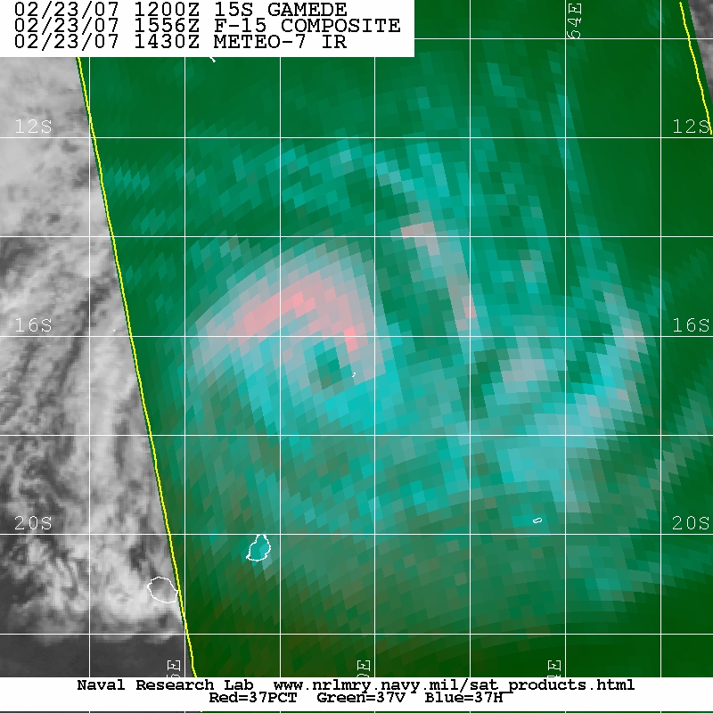
Update -- convection developed on the northeastern side of Gamede, and as the area northeast of the eye passed over St Brandon, they have had three hours of sustained winds from the WNW at 50 kt (10-min avg) or slightly higher (pressure bewteen 970 and 980 mbar), from 16Z to 18Z. Another microwave pass that happened to be timed at the onset of the higher winds is below:

20070223.1556.f15.x.color37.15SGAMEDE.90kts-954mb-164S-596E.81pc.jpg


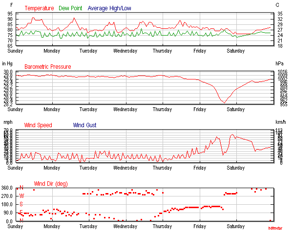
Wunderground provides nice graphics of the reports:

histGraphAll
 
Last edited by a moderator:
Margie, great post !! It would be interesting to see the behavior of the Indian Ocean Dipole Oscillation to verify if it is in the positive mode.

1048180030042__IOD.jpg
 
Yes I saw those obs but the Mauritius bulletin earlier said as it passed by the centre was 955hPa with max winds of 125km/h gusting to 180km/h. I suspect given the obs and what RSMC La Reunion have said in their last update that is just how they viewed the storm rather than actual obs.

Up to 75kts now with a minimum pressure in the centre of 956hPa.

2.B OTHER INFORMATIONS:
T=CI=5.0-
"GAMEDE" PRESENTS A VERY BROAD STRUCTURE WITH A PRESSURE GRADIENT LESS
STRONG THAN IT SHOULD BE FOR A SMALLER SYSTEM (SO, STRONG WINDS EXTENDS
VERY FAR FROM THE CENTER, BUT NEAR THE CENTER, WINDS ARE LESS STRONG THAN
THEY WOULD BE FOR SUCH A MINIMAL PRESSURE... THIS FACT HAS BEEN
CONFIRMED BY ST-BRA
NDON DATA, IN THE EYE AT 12UTC, XHERE MSLP WAS AT 957HPA, BUT MAX 10MIN
WINDS HASN'T BEEN STRONGER THAN 50KT).

MSLP PROBABLY LOWER THAN USUALLY WIND-PRESSURE RELATION IN THE SWIO (THIS
FACT IS CONFIRMED BY 960 HPA IN ST-BRANDON AT 1100UTC WHEN THE STATION
WAS IN THE EYE IN THE SOUTHWESTERN QUADRANT).
TAKING ADVANTAGE OF A FAVOURABLE ENVIRONMENT (WITH A PARTICULARLY
EFFICIENT EQUATORWARD OUTFLOW), "GAMEDE" IS EXPECTED TO INTENSIFY
GRADUALLY ALONG A WEST-SOUTHWESTWARDS TRACK.
BETWWEEN 48 AND 72 H, NUMERICAL MODELS ARE NOT IN GOOD AGREEMENT ANYMORE,
SOME MAKING IT TRACK SOUTHWESTWARDS, AND OTHER CURVE SOUTHWARDS.

Edit - Just checking the latest obs the max winds are now 100km/h but the pressure had risen to 976hPa by that time. I believe the local time is GMT+4 checking it on Google.

9:00 PM 25 °C 24 °C 89% 976 hPa - WNW 100.0 km/h / - -
AAXX 23174 61986 46/// /3054 10251 20235 39751 49755 53112
 
I believe the local time is GMT+4.

Yups (here's a link to my favorite online time converter). I went back and annotated the 1-min vs. 10-min windspeeds, which I'd neglected to do. I'm starting to hate the US being on 1-min avg. Between that and trying to decide do I want to post windspeeds in kt, mph, or kph, or all three (that certainly seems like overkill)...grrr. I'm not yet able to convert them all automatically in my head (not sure why, as pre-Euro I could equivalence between three or four currencies in my head with no problem!). But I generally try to stick with knots.

Both Gamede and Humba have gained ground today.
 
Ah finally someone seeing sense. I'd like the USA to change to a proper ten minute average as well to be the same as the rest of the world. Unless stated whenever I give a wind average it is a ten minute one. The default when I checked that Wunderground page appeared to be km/h so I just left it instead of changing to kts (If there is that option). You missed off m/s as the base unit of speed.:D

Gamede remains a large system, although not quite as large as a while ago when 30kt winds extended out 500km. The forecast now peaks at 85kts.

2.A POSITION 2007/02/24 AT 0000 UTC :
17.1S / 58.0E
(SEVENTEEN DECIMAL ONE DEGREES SOUTH AND FIFTY EIGHT DECIMAL ZERO
DEGREES
EAST)

3.A DVORAK ANALYSIS : 4.5/5.0 /S
4.A CENTRAL PRESSURE : 956 HPA
5.A MAX AVERAGE WIND SPEED (10 MN) : 70 KT

6.A EXTENSION OF WINDS BY QUADRANTS (KM):
30 KT NE: 400 SE: 450 SO: 450 NO: 300
50 KT NE: 120 SE: 120 SO: 120 NO: 120
 
That is funny, because that's the one that I can usually remember when relating to knots (maybe from reviewing historical buoy obs in the GOM).

It's a little strange to be looking at tropical cyclones when the wind is blowing sleet against the windows and a winter storm is about to hit (latest forecast calling for almost 18 inches of snow in Minneapolis -- 45 cm :) -- by Sunday evening).

Looking at the water vapor over the past twelve hours, it looks like the dry air that has been somewhat hampering Gamede all along, made inroads into the developing convection...dry air moved closer from about 22S to 20S over that timeframe, and some wrapped all the way around; on the most recent images (since about 00Z) it sliced through some of the convection.

20070224.0230.meteo7.x.wv1km.15SGAMEDE.90kts-954mb-169S-580E.100pc.jpg
 
Gamede's large, broad stable circulation has been affecting many of the islands to the east of Madagascar for the past day. Strong sustained winds ranging from 20 to 45 kt have been felt by Tromelin, St Brandon (which stopped reporting), Rodrigues (which also stopped reporting), Mauritius, and La Reunion over the last 12-24 hours. All of these various locations are many miles apart and many miles from the center of the circulation, which is striking on satellite IR imagery. If you look closely all five of these islands are in the image below:

20070224.2230.meteo7.x.ir1km_bw.15SGAMEDE.90kts-954mb-185S-561E.100pc.jpg


In comparing today's water vapor from yesterday, the circulation is well-established, but the deep convection from yesterday, especially around the center, is mostly dissipated. Currently (at around 2300Z) Gamede is trying once again to wrap convection around what has become a well-defined warming eye, but there's a lot of dry air being pulled into the circulation:

20070224.1900.meteo7.x.wv1km.15SGAMEDE.90kts-954mb-185S-561E.100pc.jpg
 
Finally...Meteo 7 images are available. Here's a recent water vapor (for continuity with previous posts). An 1803Z microwave showed Gamede had intensified, but I wanted to wait for a wv image before posting. Convection was able to wrap around the eye overnight, and the eye has become very well-defined and the eye temp has warmed a little...and that will probably be the best indicator in the coming hours of whether Gamede is intensifying any further.

20070225.2300.meteo7.x.wv1km.15SGAMEDE.105kts-938mb-185S-540E.100pc.jpg
 
Back
Top