Name That Target - Round II

I like Hollingshead's thinking. If I am correct I played too far north that day and busted. I am heading to Wichita right now but may end up somewhere just a little bit SW of there. ;) That day was a tricky forecast. All of you further north had better get south on 135 quickly.
 
Thank goodness I got enough from the SPC site to help me figure this forecast out ...

MUCH OF THE ACTIVITY IS BECOMING MORE FOCUSED ACROSS THIS REGION AT THIS TIME. PRESSURE FALLS ARE MORE CONCENTRATED IN AN AREA BOUNDED BY XXX-XXX-XXX-XXX AND SURFACE WINDS ARE BACKING ACROSS XXX DEVELOPING INFLOW TOWARDS THE LOW
XXX of XXX AIR MASS IS VERY MOIST AND BECOMING VERY UNSTABLE WITH SFC DEW POINTS UPR 60S TO LOW 70S...AND DAYTIME HEATING RAISING SBCAPE TO BETWEEN 4500-5500 J/KG /MLCAPE 2500-3500 J/KG/. 18Z RAOB DATA SHOWS CAPE JUST UNDER 4500 J/KG AT TOP WITH A MID LEVEL LAPSE RATE OF 9C/KM. WHILE SHEAR HAS YET TO RESPOND TO APPROACHING TROUGH...RUC MODEL FORECASTS DEEP LAYER SHEAR WILL BE AROUND 40 KT BY 13/00Z FAVORABLE FOR TORNADOES NEAR THE SW-NE BOUNDARY THAT WILL BE ACROSS
THE AREA BY THAT TIME. ALSO...CONSIDERING THE LARGE CAPE/VERY
STEEP LAPSE RATES...THE THREAT FOR VERY LARGE HAIL WILL BE PRESENT ACROSS THE REGION.

DRYLINE IS MOVING SLOWLY EWD EXTENDING FROM THE LOW BETWEEN XXX/XXX THROUGH XXX AND XXX INTO XXX. ADDITIONAL SEVERE
THUNDERSTORMS ARE EXPECTED TO DEVELOP SWD ALONG THE DRYLINE AS MID/UPPER LEVEL SHORTWAVE TROUGH ENHANCES UVVS BY EVENING. STEEP LAPSE RATES COMBINED WITH DEEP LAYER SHEAR OF 30-40 KT INDICATES POTENTIAL FOR SUPERCELL STORMS PRODUCING LARGE HAIL...STRONG WINDS AND ISOLATED TORNADOES.
 
OK ... time to relieve the suspense ...

If you came with me on this day, you would have seen this:

5-12%20Storm0044.JPG


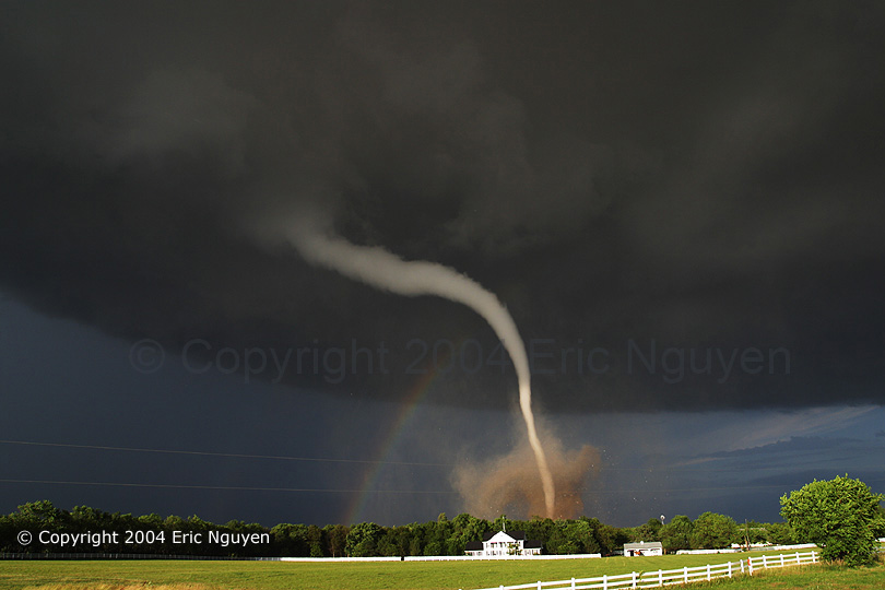
Kinda cool yes ... BUT if you had gone with Eric Nguyen (and lots of others), you would have seen this:

040612-15.jpg


Definitely a tricky forecast day ... the most INTERESTING thing about this discussion today is that it was an almost IDENTICAL replica of the reasoning that chasers employed to arrive at their targets on June 12, 2004.

I'd say that Mike gets it first for naming the specific target, though the earlier calls of the dryline bulge and Salina were also close enough that it's tough to call. Mike can have the choice of either doing the next contest or delegating it to someone else - - -

Thanks for playing -
 
Well, I know this is moot and after-the-fact,

But before I got sidetracked onto work today (at work - shock horror!), I read some of this thread and positioned myself at 9am in Salina OR Concordia KS sipping a Cappuccino and watching data.

Who knows whether I would have made it or not........but it's sure a better starting point that then REAL one we had this day!!!! :lol:

KR
 
Nick can have it if he wants or someone else.

*Most* chasers this day were up in se NE I believe. I saw tons of them including several vets(Hoadley, Marshall, Gold, DOWs......). I believe Piotrwoski was up here as well but got some of the later Mulvane action(likely due to leaving the early crapfest that got going in se NE and heading in the direction towards home). The northern target in se NE got hosed because of early convection leaving a rather strong outflow boundary in the area. Stuff fired on this boundary far too early and had trouble being undercut by it(north side of it was quite cold and never got a chance to heat up any).

Edit: Maybe I didn't see Marshall(according to KERs post/account). I saw him late June 10th on I-80 going east and then again near Ft. Dodge at a gas station the next day(11th). I swore I saw his truck in the mix the 12th too but perhaps not.
 
Nick can have it if he wants or someone else.

*Most* chasers this day were up in se NE I believe. I saw tons of them including several vets(Hoadley, Marshal, Gold, DOWs......). I believe Piotrwoski was up here as well but got some of the later Mulvane action(likely due to leaving the early crapfest that got going in se NE and heading in the direction towards home). The northern target in se NE got hosed because of early convection leaving a rather strong outflow boundary in the area. Stuff fired on this boundary far too early and had trouble being undercut by it(north side of it was quite cold and never got a chance to heat up any).

:lol: LOL... Sure, I'll make a new thread when I get off work in a few hours.
 
Ah, June 12th. Good case. No wonder northern Kansas looked so tempting... it was!... until the outflow boundary of death raced south out of Nebraska and killed the sharp convection that had begun to develop.
 
I would have said KS as well...

When I see a very tight CAPE gradient like that with a shortwave trough rotating through, that's usually a good bet. Also, I would assume the mid level thermal axis would be just east of the area, so a weakening CAP would be present versus a strengthening CAP over SE NE...
 
...I believe Piotrwoski was up here as well but got some of the later Mulvane action...

There were definitely a lot of chasers in the northern target. Jeff Piotrowski pulled up with a media passenger across the road from me about 15 minutes before the above photo was taken. I can't see how he could have possibly in a million years made it south quick enough to Mulvane ... if that is for real then I will have learned something new today ...

When we finally gave up on the outflow fest (which was located directly over Hallam again ... poor Hallam was under a new tornado warning just a couple weeks after being destroyed ... ), we turned back south to encounter a POWER gust front, complete with several pretty cool-looking gustnadoes in north-central Kansas.

oh ... and by the way ...

Just in case anyone felt bad for naming Minnesota or an area outside of Kansas ... the SPC was thinking the same thing during the first outlook of the morning, which placed the greatest risk for tornadoes (5% prob at the time) over SE Minnesota and western Wisconsin. It wasn't until later in the morning that things became focused more on Kansas.
 
Well, this makes two virtual chase days I completely blew but I saw tornadoes on the real days. I must be the worst armchair chaser in the world :roll:
 
Ack! Ya'll jumped the gun on it! :p I was going to say Mulvane, KS...I knew I had seen those 500 mb maps before (Jon Davies' website).

However, I must say that NE KS looked mighty tasty from those first maps. It was located at the leading edge of the entering s/w trof and in the right entrance region of the departing jet. Add a dryline bulge and extreme CAPE, and there is no doubt why many folks got hosed on the northern target.

I actually targeted Wellington, KS that day (more for proximity to Norman than anything). :) Gotta love outflow boundaries!

Gabe
 
Darn, I logged on too late to try this one. I would have said Salina, Kansas. I ran into Blake Naftel up in Iowa that day and we targeted Topeka, Kansas. My dad and I ended up chasing the stuff in southeast Nebraska and did not see much of anything. I should have recognized this, because Tim Vasquez used this example at the forecasting class at the 2005 storm chaser convention. :lol:
 
Back
Top