Lets see some Nexrad!

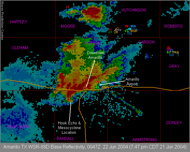
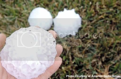
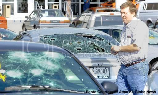
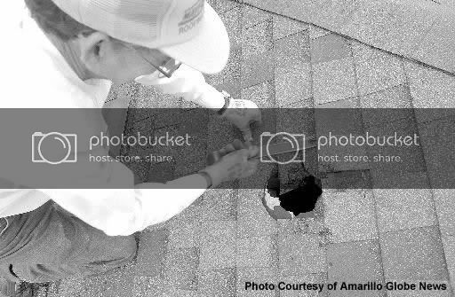
Another example of traffic... (AMA is well known for this)
nice_AMA.jpg


A nice squall line...
squallline.jpg


Stereotypical 3-D structure of a large, cyclic supercell (what you see more often than not based off my experience; supercells' 3-D Z structure can actually vary quite substantially)
ktlx053004.jpg


Just a nice typhoon...
typhoon.gif


Too many to post! Props to Tom for displaying the 5/1-5/2/2002 supercells. The southern storm goes down as one of the most impressive I've personally witnessed on radar. It tracked from St. Louis to N.C.

Aaron
 
Thanks for posting the pictures! Those are some very impressive storms. I'm trying to dig up some that I took last year, but I'm having problems finding my flash drive....doh.

I was curious if anyone has some Nexrad captures with returns in 75+ dbz range? Lets see those big hailers!
 
A nice squall line...

Nice? What you have there is monstrous in terms of scale. I like the traffic grabs you and Jeff submitted. Radar anomalies can be very enlightening. Here are my submissions:

Two Springfields in one evening...

Springfield, MO 03-12-06 - 22:19 CST
Springfield_MO_2219_CST.jpg


Springfield, IL 03-12-06 - 20:20 CST
Springfield_IL_2020_CST.jpg


Storms fire along an outflow boundary near Odessa, TX 05-04-06
WUNIDS_map.gif


Bats leaving their cave north of Uvalde on the same night 05-04-06
cb6b7bd6.gif
 
Last edited by a moderator:
Sure are some great screenshots here. Really like the 3-D images, which software package produces them?

While not as spectacular due to our EC radar page, the storm that produced the images did some spectacular damage, and almost landed a 200+ year-old tree in my living room. In the pic, my house is on the left.


John
www.skywatch7.com
 

Attachments

  • XWL_CAPPI_2005_07_17_04_50.jpg
    XWL_CAPPI_2005_07_17_04_50.jpg
    83.9 KB · Views: 69
  • 112-1214_IMG_1_1.jpg
    112-1214_IMG_1_1.jpg
    50.6 KB · Views: 75
Here is a storm that hit Amarillo, TX on June 21, 2004. It had 4+ inch hail (that i was able to stay out of) and 4 or so confirmed tornadoes (all F0 or F1).
ref0047.gif


Here are a couple pictures of what the hail did across western Amarillo. I drove around that side of town the next day and there were trees branches down everywhere and just about every car was missing a window. Definitely the worst hail damage I have ever seen.
18169_512_jpg.jpg

18168_512_jpg.jpg

18199_512_big.jpg


Also here is a link to the radar loop for the afternoon.
http://www.srh.noaa.gov/ama/June212004/radarloop.htmhttp://http://www.srh.noaa.gov/ama/June212004/radarloop.htm
 
Last edited by a moderator:
From August 24, 2006 in South Dakota:
supercell_2.png


Reflectivity at the time of the Roanoke, IL F4 (it was hitting the Parson's plant at this time; hence the area of high reflectivity at the tip of the hook from debris):
roanoke5_2.png


Storm Relative Velocity of the Roanoke, IL tornado:
roanoke3_2.png
 
The first few grabs were from a storm that I caught moving across the northern side of the Houston area. It produced close to baseball sized hail and the best structure I have seen here along the gulf coast. It had bright white hail streaks coming out of the back of it and at the same time my friend was caught in golf ball sized hail that severely damaged his car. As you can see from the radar, this storm topped out above 50kft!

http://weather.xonelabs.com/050406 Hail Core Cross Section 2138z.png

http://weather.xonelabs.com/050406 MEHS2 Zoom.png

http://weather.xonelabs.com/050406 ref1.png

The next few are from the March 2000 Fort Worth tornado.

http://weather.xonelabs.com/Fort Worth Ref.png

http://weather.xonelabs.com/Fort Worth vel.png

http://weather.xonelabs.com/Fort Worth 032800 Hail Core.png
 
home.jpg

tornado2-3.gif

tornado1.gif

small_track.png


This was about as close of a "backyard" chase as I ever want to have, lol. It hit the apartment complexe i am living in now, and missed the guy's hose who was chasing with me by about 1/2 a mile at the most.
 
Nashville radar showing three supercells over Middle Tennessee on 11/10/2002 at 2339 UTC. The lines show the projected motion over the next 60 minutes (they are training).

OHX20021110-2339.png


Memphis radar showing a supercell with a hook echo at extremely close range on the evening of 11/09/2002.

NQA20021110-0250.png
 
I'll start off by saying, sorry for the "shameless plug".

I'm awfully obsessed with radar images of classic supercells. That's why I follow severe wx so much despite being in the area I live in.

Here's my weather page: http://www.geocities.com/wxmann_91/weather.html

A lot of grabs in the "Severe Wx" section of events and outbreaks. Yeah page is a little ugly looking but I'll update it in the future. Anyway enjoy...
 
Back
Top