• A friendly and periodic reminder of the rules we use for fostering high SNR and quality conversation and interaction at Stormtrack: Forum rules

    P.S. - Nothing specific happened to prompt this message! No one is in trouble, there are no flame wars in effect, nor any inappropriate conversation ongoing. This is being posted sitewide as a casual refresher.

Open Source Weather Radar Software - Supercell Wx

D Paulat

EF0
Joined
Apr 13, 2023
Messages
11
Location
Missouri
I see people post from time to time, asking about free or inexpensive software to consume Level 2 and Level 3 radar data. With few free and/or open source options available, and being obsessed with weather for longer than I can remember, I've decided to challenge myself with developing a desktop application for tracking severe weather in my free time.

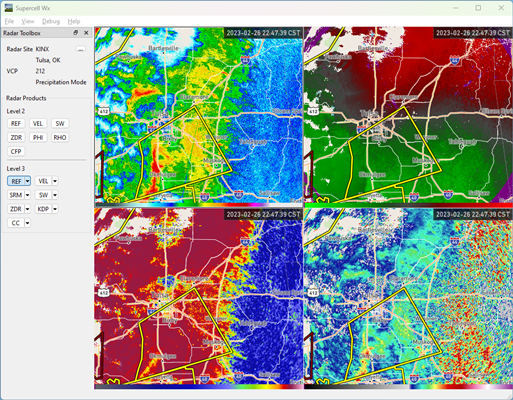
Supercell Wx is a free, open source application to visualize live NEXRAD Level 2 and Level 3 data, and severe weather alerts. It displays continuously updating weather data on top of a responsive map, providing the capability to monitor weather events using reflectivity, velocity, and other products.

You can find documentation here, including info for first-time setup: Supercell Wx — Supercell Wx documentation
The latest release is available on GitHub: Releases · dpaulat/supercell-wx

68747470733a2f2f737570657263656c6c2d77782e72656164746865646f63732e696f2f656e2f6c61746573742f5f696d616765732f696e697469616c2d73657475702d30332d696e697469616c2d636f6e666967757265642d736d616c6c2e706e67


It's not as fully featured as many of the paid options out there, but it does provide a base level of functionality. I'm continuing to develop the application, and add new features. I've been using it myself to track some of the recent storms, and feel I'm ready to share my progress. I hope the community can benefit as well!
 
Been wanting to get a simple free windows radar app, so this looks like a good option to check out! :)

I looked around alittle at the info on those 2 links.
Do you have an actual download link (github is difficult to navigate/find anything on...especially with updates they've made to the site in the past year .lol. )
 
Is this primarily a Windows application or is there also a Linux or MacOS version? My biggest issue for years is that I've been tied to Windows primarily because of GRL3 and my radio programming software.
 
I tried it, but when I run the supercell-wx.exe file, I get an error (see attached image)
I also tried installing the included Visual C Redistributable, but still get the same err
 

Attachments

  • sswx_err.jpg
    sswx_err.jpg
    38.5 KB · Views: 1
James, you're still running XP right? Or do you have a Win 7 machine? I forget if you have a machine running 7 or not. That might be playing a role here since those are older OSs
 
I've only tested the application with Windows 10 and 11.

Did you get any text output in a console before the error message?

Are you running Windows 7 32-bit or 64-bit? The executable requires 64-bit. I believe you can check using Win Key+R, and typing "winver". The error message looks to me like you might be running 32-bit.

I will test on Windows 7 tonight, and can see if I can kick out a 32-bit version.
 
@Drew Terril: I do have an Win XP system.. but thats the one I use for video editing...its purposely not internet connected.
In the the case where I tested on a Win 7 system.

@D Paulat:
Its 64-bit
I'll also check on Win 8 64-bit later .. just turned on another computer so I can watch Reed & a couple others YouTube streams.....
 
Good to know. I suspect Windows 8 might have issues being older, an updated 8.1 system might have better luck working. I'll dig more tonight to see if I can reproduce the issue.
 
I am seeing other various compatibility issues running Windows 7 through 8.1. The minimum requirements appear to be Windows 10 21H2 (1809 or later), although it may work as early as version 1607.
 
I tried on the win 8 computer (8.1 actually) & got the err attached below.

But makes sense that it won't work if it was designed for Win 10/11...
Oh well, was still worth trying :)
 

Attachments

  • swx_err2.jpg
    swx_err2.jpg
    31.2 KB · Views: 1
Installed and runs great on Windows 10 build 19044.2846, AMD Ryzen 3900X / AMD 5700XT video card.

If this is your first release I have to say excellent work. Love the ability to show Level 2 and Level 3 data in the same application. Love the responsive window where you can move the product selector to the top or left side. I also like having the debug window, for geeks this is awesome. This program is simple and easy to understand, and get running fast unlike the NWS offering.

Mapbox looks to be completely free, but it wants a credit card so I don't have maps at the moment. I do see where you can "Go" to an active alert, would suggest also adding ability to "go" by double clicking on a warning if possible. I have been a user of GR products and WSV3 for years, and I have skimmed over various discussions about certain radar features and technologies that are patented so you need to read up on those things if you don't already know about them. Looking forward to testing your next releases.
 
Great to hear the graphics render on an AMD video card! I've only been able to test with NVIDIA and Intel graphics hardware. I considered hiding the debug window, but I'm glad I didn't :cool:!

Mapbox requiring a credit card looks to be a new development (although still advertises the free tier). I planned to support other map sources (e.g. MapTiler) later down the road (as well as a basic offline map instead of the black screen), but it looks like I'll be adding that capability sooner rather than later. It's not my intention to require users to need their credit card to sign up for anything.

Adding the "Go" on double-click won't be difficult. I've added that to the to do list.

Thanks for the heads up on the patents. I will do some research to make sure I steer clear of any legal issues. While I'm minimally familiar with GR and WSV3, I've tried to limit my exposure to them, in order to not develop a clone of their functionalities. Instead, I'm taking the approach of integrating and displaying information from public data sources. With that said, Mike Gibson was generous enough to grant usage of his Color Table Specification, allowing integration of themes already developed by various communities.

Thanks for the great feedback, it's appreciated!
 
Mike is a great programmer and obviously a great guy! Thinking about this a bit more, I want to say Baron Weather was a company to look at for something that might be infringing. Here is one case where they went after someone else alleging patent infringement.

Patent # cited:

That patent includes having a geographic grid overlay with ETA of a storm to a location. WSV3 has this feature but GR3 does not and it has been stated over and over Baron's patent prevented GR from adding this feature.
 
I just checked out this software. the app did opened for me but I have to sign up for API key. when I sign up at mapbox. It asked me for credit card. I will not give my credit card info. need to choose alternative for map. might openstreet map.
 
I just checked out this software. the app did opened for me but I have to sign up for API key. when I sign up at mapbox. It asked me for credit card. I will not give my credit card info. need to choose alternative for map. might openstreet map.

I have a new version that should be ready soon, supporting MapTiler as the default over Mapbox. Unfortunately Mapbox decided to start requiring credit cards despite having a free tier some time ago.
 
Last edited:
I'll serve as a guinea pig for the Linux version once things settle down on my end in a few weeks. I'll try it initially on my really old machine that I use primarily for digital HF modes, but I'll also test it on one of my newer machines
 
I've downloaded this program. You need to have a Maptiler Key, but they do not require the use of a CC. Looks pretty interesting. Will keep looking/testing it.
 
The documentation has been updated for this latest release: Supercell Wx — Supercell Wx documentation

@Drew Terril
Let me know how the Linux version works for you. I suspect you might have problems with your older machine, as the application relies on some newer library features that older distributions might not have (the main one I would expect issues with is GCC < 11). I'm currently advertising support for Fedora 34+ and Ubuntu 22.04+.
 
Since v.11 if I have change grid width and height to 2/2 respectively, my elevations options disappear.
Love that you give a linux option. I may spin up a vm just to test it.
 
Interesting about the elevation options, I don't see that behavior, and I typically run in a 2x2 grid. The way it's currently designed is the elevation degrees will show up only if you have a level 2 product selected. If you have a level 3 product selected, there's a small arrow where you are able to select a tilt. Are you seeing different behavior?
 
Okay now I understand. Thanks for clearing that up. My products were all Level 3.
The V.11 updater alerted me to the new version so that works.

I did not see it on the roadmap but I assume you'll implement an animation / download frames option at some time?
 
Yes, an animation and archive view is in the works (I've labeled it "timeline", I should clarify that in the roadmap). It probably won't be done until next month sometime at the earliest, implementation is a bit trickier. I'm not sure I understand the "download frames" functionality though.
 
I'd be glad to give your app a try on my Windows PC. If you develop a Mac version, I'd really be interested, as while I like RadarScope on my Mac, I'm always looking for additional solutions.

While you're definitely going to keep the free/public radar sites in there for people who need a totally free storm tracking solution, any chance you'll eventually add AllisonHouse integration (where we could login with our AllisonHouse account or plug in URLs to AllisonHouse data like we can in GR) for those of us who'd want to use AllisonHouse during a time when the public servers might be saturated? That'd also be a way you could offer some premium data (such as lightning, although you could use one of the free lightning feeds for a form of basic lightning).
 
Back
Top