Minimalist Chase Forecasting: Avoiding Analysis Paralysis and Separating the Signal from the Noise

Somewhat of a digression from information overload relative to forecasting, but still worth discussing here as a “minimalist chasing” topic and equipment-related is the extent of camera and video usage. I am always torn between wanting to capture the moment and have something to show people back home, vs living in the moment and savoring the experience, without the distraction of fumbling with camera equipment, or shifting back and forth from camera to video. Or fumbling between a DSLR camera and also an iPhone so that I would have something to more easily and immediately share with family and friends back home, instead of having to wait to get back to the hotel and download the pictures/video onto my laptop. Lately I’ve been taking 90% of my pictures and video only on my iPhone, just because it’s quicker and easier, and I can use it with one hand while driving if I have to. Curious as to others’ approaches!
 
Don't want to derail too much, but wondering if people also tune in to local radio while chasing? I would assume many local TV stations still dualcast on radio (I've certainly seen it on older archive footage in OK), so that would also provide helpful updates while on the road?

Sometimes I do. The stations along the US-20/US-18 corridors in Iowa had some decent coverage on April 12, 2022, with a combination of local DJs giving spotter/damage report updates, and NOAA weather radio feeds. It was the latter that actually alerted me to the initial severe thunderstorm warning going out for the eventual Gilmore City tornado-producer (not that it ultimately did me any good on that day) as soon as I turned my car on after my food break in Fort Dodge.
 
Don't want to derail too much, but wondering if people also tune in to local radio while chasing? I would assume many local TV stations still dualcast on radio (I've certainly seen it on older archive footage in OK), so that would also provide helpful updates while on the road?
Just about any FM station in OKC metro will pick up one of the TV stations if there's a tornado warning in the metro. I've found it make excellent audio for footage. For example, my Mangum Oklahoma Tornado footage has TV station audio in the background. Luckily someone in western Oklahoma was carrying it that day.
 
@Ben Holcomb - I've mentioned it elsewhere, but I really appreciate the app Wx on Android and wXL23 on IOS for quick data. I still use Radarscope separately, but it's convenient having most of the data I want in one place instead of visiting multiple web sites.

As far as forecasting, I do a deep dive the night before to pick out a general area, then check SPC to compare. The day of, I'll look at a few basic parameters to see if things are on track with the previous assessment. The last thing I'll look at near midday is the helicity tracks and composite radar to see what, if anything, is different and why... and where the CI might fire if the cap is strong. If it's hard to make a call on a specific area, I'll go theough more parameters to till one seems better than the others. Once towers go up, or if there's been previous or ongoing convection, identifying and tracking outflow boundaries becomes part of the workflow. I like things simple, so I try to run a checklist of the needed basic ingredients and keep it consistent. As I learn more and realize past mistakes, I modify the checklist as necessary. It's still a work in progress though and fluctuations are common, lol. Once you're near your target, you only have about 100 to 150 miles of leeway, so then it becomes a decision of which storm, or bailing to another area all together. But once you're on the chase, it's all about visual cues and radar interpretation.

With the complexity of not just the atmosphere, but the forecasting of meso scale and storm scale phenomenon, pattern recognition is probably the biggest help... especially considering how much luck is actually involved in varying levels of success. I can imagine having a chase partner or 2 would alleviate some of issues with info overload, amongst other things.
 
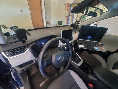
From an equipment standpoint I am not the most minimalist, but I am pretty close to it. I have Radarscope on my phone (left side of the wheel) and I also have Android Auto which allows me to run Google Maps on the vehicle display in my Rav4 (the vehicle is also my hotspot), so it's killing multiple birds with one stone there. I live stream to YouTube so I still have a laptop and stand and keep my dash camera in the passenger corner so I don't have an obstructive view through the windshield while driving. I also run GR3 on my laptop so I have backup radar and a way to see reflectivity if I'm looking at velocities in Radarscope. It used to be just phone for a while but I like having multiple ways to get data if I'm in a tough area.

Edit: I don't usually mess with the dash cam as far as panning or zooming so I don't mind it being out of reach. Streaming is a non-priority and more for the fun of it so I don't care if I get great video or not.

20240326_124819.jpg
 
I do like the Android app Wx too. Mostly use it for viewing observed soundings while laying in bed or the satellite/water vapor.

@Sean Ramsey how hard was radarscope on the RAV4 screen? I've likely got the same screen as you in my 21 Camry, so this is relevant to my interests. I love the built in AT&T hotspot as well and use a Verizon hotspot as well. I haven't gone without data for long on a chase since having both.

My "new" (as of December 2022, technically my wife's but don't let her see the video @Michael McClellan caught of me standing outside it pulled over on IA-92 as he drove by on W-15 with the Keota EF4 in the background!) 2021 Hyundai Santa Fe has Android Auto capability; but when I installed it on my phone it seemed there was only a limited number of apps I could display on the vehicle screen, and RadarScope was not one of them. Would be delighted if someone has figured out a way to do that.
 
@Ben Holcomb My RAV4 is a 2023 and as far as I can tell you can't run Radarscope on the main display. As Andy mentioned I think it's limited to a handful of apps and Radarscope isn't one of them, but Google Maps is. I dedicate the main display to Google Maps and run Radarscope on my phone which works perfectly for me because I have a harder time seeing the small print for roads, highway numbers, etc. on the phone nowadays so the main display helps with that tremendously.

Have to add that I had a 2022 Tacoma and had the same setup but the main display was junk when it came to mapping and didn't show any of the detail that Google Maps did. The 2023 display shows maps exactly as it does on the phone so it's super detailed. This plus being able to run Android Auto wirelessly was a game changer for my setup.
 
Reading comprehension fail. I read google maps as radarscope and was thinking that would be a gamechanging cool thing to do.
 
Somewhat of a digression from information overload relative to forecasting, but still worth discussing here as a “minimalist chasing” topic and equipment-related is the extent of camera and video usage. I am always torn between wanting to capture the moment and have something to show people back home, vs living in the moment and savoring the experience, without the distraction of fumbling with camera equipment, or shifting back and forth from camera to video. Or fumbling between a DSLR camera and also an iPhone so that I would have something to more easily and immediately share with family and friends back home, instead of having to wait to get back to the hotel and download the pictures/video onto my laptop. Lately I’ve been taking 90% of my pictures and video only on my iPhone, just because it’s quicker and easier, and I can use it with one hand while driving if I have to. Curious as to others’ approaches!

Throughout most of my chasing years, I've focused primarily on stills, and only get video when I can "fire and forget", meaning it's either on my dash, or I'm going to be stopped long enough to put a camcorder on a tripod and let it run for a while. I feel a lot more "in the moment" when I'm working an SLR vs trying to get video, although this admittedly might be an artifact of both my preference for photography as well as years spent getting shots at races, and the setting manipulation to get the shots I want rather than having to go in post production to get it. In recent years, I've gone back to my photography roots and shoot as much (if not more) with my film SLR as I do digital.

What video I have gotten over the years just sits on hard drives and memory cards, and I have yet to actually upload anything anywhere. Stills, on the other hand, being where my passion lies, generally do get posted. It usually takes some time for me actually get things up, and my film work is hurt by there being nobody nearby who processes film like I had available in OKC (I still have a roll of film from last year's Indy 500 as well as one from 6/25 last year that needs developed), but it usually does get shared.
 
I chase solo and since I don't have people looking at data and helping with directions I need to make fast chase decisions myself. I look at surface obs and satellite imagery when I stop on the way to the target area and will also take a quick look at CAMs. I still use a large laptop with a Ram mount and I have navigation on that I use to take a quick look for roads. I run GrL2 or 3 with a mobile hotspot and cell booster but also have radarscope on to refer to. I use a front and rear dashcam and just started using the film tools mount with the AX53. It's a process of making the target area smaller as the day goes on and maybe while driving to that target. Looking at the mesoanalysis page info really helps in this area and when I get close I keep echo tops on to see initiation if I cannot see it with my own eyes. I stay off social media for the most part to avoid what others have said about other targets making me guess mine. I do talk to a couple people sometimes but I always give my target area and reasons first.
 
I have overall, simplified my setup and thinking over the years so that chasing remains as stress free as I can make it. I no longer chase everything, go too crazy forecasting, stretch too far on conditional forecasts, dork with too much gear or apps, etc. My tone is to try to keep it fun, relaxing and minimize the bad stuff. If a setup starts to feel like a chore or bust risk, I am likely to bail before or during, and be happy even if I miss something.

I use Pivotal Weather for forecast and GRL3 on a tablet in the field, with quad screen layout of reflectivity, velocity, echotops, 3-hour rainfall and a bunch of data overlays for hail, lightning, frontal positions, etc. I exclusively use SPC mesoanalysis page for surface observations and RAP analsysis in the field. I run navigation on the car screen; google maps or the native garmin map which calls out approaching sideroads for me.

In regards to specific question areas posed:

Analysis paralysis: I've had it many times in the past, born of stress of cost vs. reward failures, and wanting to prevent repeats. I began overthinking to try to improve success rates. In the end I found overthinking was stressful without significantly improving success. Instead, simplifying how I thought about chasing and focusing on the desired experience I want from it minimized costs and increased the success rate.

“shorthand” forecasting process: I use the same set of questions, in order, for every forecast: Will I chase in that area? Will sufficient shear and moisture exist and overlap? Is environment unstable but at least slightly capped? Will there be reasonable chance for initiation? If those ingredients are not all confirmed, or still appear stored separately on the 'shelves', it is clear we are not having supercell cookies worth eating. Forecast over, chase dismissed. If we are possibly having delicious cookies, I work harder on the specifics of how they will be prepared (long forecast).

how long forecasting an event:
For obvious 'classic' setups in terrain I like, < 1-2 hours. For subtle scenarios or those in my 'maybe' category, several hours, allowing for go/no go decision up to morning of. For longer distance or multiday chases, more effort before making the commitment. For monsoon, go outside and hope. For a backyward chase, go outside with little forecasting because why not?

reconciling competing model solutions (particularly HRRR):
Each model has to be consistent for many runs to gain trust in the member, and models have to agree with each other for me to gain confidence something will happen. If models disagree I consider biases and check how well each initializes to reality, pick a favorite, and ignore the others until they correct. For CAMs, I ignore completely more than ~24 hours out, remain skeptical until 12 hours out, expect a minimum of ~6 consistent runs before willing to make decisions weighted to them.

composite parameters as shorthand:
Not for me. This obfuscates initiation, quality, and so much more, etc.

data in the field: Almost no long term model use once in the field (maybe a peak at CAMs if there was a previous question of consistency resolving). I heavily use RAP model mesoanalysis and surface observation in the field to fine tune position before a chase starts. Once initiation starts I mainly focus on eyes and radar, and only return to mesoanalysis data if the storms available to me are not satisfactory and I need to relocate.

avoid biases: I don't go out of my way to avoid bias that relates to what I prefer. I do work a lot harder to remain aware of reality rather than forecast expectations after a few bad busts out of position from biased thinking.
 
I use a laptop with GR3 and expect to for the foreseeable future. My chase partner developed amazing surface ob placefiles (Brandon Vincent at Red Team WX). Combined with detailed road shapefiles and GPS puck allowing real time position on top of radar/surface obs I get most of what I need from a glance at a single screen. Will keep mesoanalysis and COD satellite tabs on the browser on approach but don't use them much after initiation. Maybe something will come along one day that negates the laptop but I haven't seen anything close to the one-stop-shop I have now.
 
Back
Top