Derecho: Is the term overused.

Joined
Dec 4, 2003
Messages
1,697
Location
Grand Rapids, Michigan
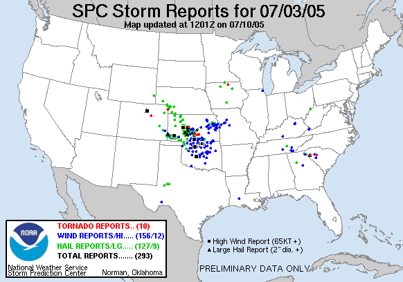
Is the term Derecho overused, often people use the term derecho much too often, the original definition was more detailed in specifying what constitutes a derecho, now it seem, the term derecho is used loosely with any linear storms, that have a lot of wind reports.

From: METED UCAR also Johns and Hirt
Long-lived convective systems that produce extensive and nearly continuous straight-line wind damage are called derechos. Deh-RAY-cho is a Spanish word, which can be interpreted as meaning “straight ahead.\" To be classified as a derecho a single convective system must produce wind damage or gusts greater than 26 m/s (50 kt) within a concentrated path area at least 400 km (215 n mi) long. The severe wind reports must exhibit a chronological progression and there must be at least three reports of F1 damage and/or convective wind gusts of 33 m/s (65 kt) or greater separated by at least 64 km (35 n mi). Additionally, no more than three hours can elapse between successive wind damage or gust events

I notice the defintion for Derechos have change somewhat in literature:

Source: AMS Glossary
derecho—A widespread convectively induced straight-line windstorm.
Specifically, the term is defined as any family of downburst clusters produced by an extratropical mesoscale convective system. Derechos may or may not be accompanied by tornadoes. Such events were first recognized in the Corn Belt region of the United States, but have since been observed in many other areas of the midlatitudes.
Source: NWS Detroit Glossary
Derecho: (Pronounced day-RAY-cho) A widespread and usually fast-moving windstorm associated with convection. Derechos include any family of downburst clusters produced by an extratropical mesoscale convective weather system (MCS), and can produce damaging straight-line winds over areas hundreds of miles long and more than 100 miles across. There are 2 types of derecho-producing convective systems. They are serial and progressive.
Source: NWS Norman Spotters Glossary
Derecho - (Pronounced deh-REY-cho), a widespread and usually fast-moving windstorm associated with convection. Derechos include any family of downburst clusters produced by an extratropical MCS, and can produce damaging straight-line winds over areas hundreds of miles long and more than 100 miles across.
Source: Storm Prediction Center
What is a derecho?
A derecho (pronounced similar to \"deh-RAY-cho\" in English or pronounced phonetically as \"\") is a widespread and long lived windstorm that is associated with a band of rapidly moving showers or thunderstorms.
Mike
 
Well, technically, it would seem that if there is a linear configuration of storms that produces an unusually widespread amount of wind damage, it would be a derecho. I use the term whenever there are very strong dynamics and instability in place, and conditions which satisfy the old SELS derecho checklist. It would seem that tomorrow/tomorrow nights event certainly satisfies that checklist, but it's hard to classify an event as a derecho until after the fact.
 
I think the term is way over used. There's a fine line between your general squall line or MCS that may produce winds 60-70 MPH, and your derecho that spans out for miles, moves very quickly and produces a large swath of wind damage caused by 80 mph+ gusts.
 
Very interesting issue. We have to be careful with the use of some therms. I am learning a lot from the therms used by american meteorologists, with a very long experience in severe weather, and I consider them as a point of reference. Anyway, for example in Spain, we have to make some modifications for adjusting them to the size and intensity of severe weather phenomena in my Country.
 
Originally posted by Anthony Silver
I think the term is way over used. There's a fine line between your general squall line or MCS that may produce winds 60-70 MPH, and your derecho that spans out for miles, moves very quickly and produces a large swath of wind damage caused by 80 mph+ gusts.

A derecho simply needs to produce wind gusts to 60mph, nothing more. And, it needs to be persistant and produce alot of reports. Other than that, a derecho is simply a long lived squall line, without an exact definition... Really, you don't need 90-100mph wind gusts that persist from MN to NY. I don't think the term is all that over-used, other than in the sense that when a derecho is forecast, it doesn't exactly materialize.

Check out some of the examples over at SPC, some dercho's were only 50 miles long, and tracked for ~100 miles at best: http://www.spc.noaa.gov/misc/AbtDerechos/derechofacts

Go to the Target Area and check out the FCST/TALK threads for today, and you will see that today is nearly a perfect setup for a derecho (passes the entire SELS checklist) - but will it happen?
 
Originally posted by rdewey+--><div class='quotetop'>QUOTE(rdewey)</div>
<!--QuoteBegin-Anthony Silver
I think the term is way over used. There's a fine line between your general squall line or MCS that may produce winds 60-70 MPH, and your derecho that spans out for miles, moves very quickly and produces a large swath of wind damage caused by 80 mph+ gusts.

A derecho simply needs to produce wind gusts to 60mph, nothing more. And, it needs to be persistant and produce alot of reports. Other than that, a derecho is simply a long lived squall line, without an exact definition... Really, you don't need 90-100mph wind gusts that persist from MN to NY. I don't think the term is all that over-used, other than in the sense that when a derecho is forecast, it doesn't exactly materialize.
[/b]

I think by definition, perhaps. But, "derecho" usually implies a high-end wind event, one with numerous >74mph wind gusts. I suppose that a long-lived squall-line that produces numerous 60mph gusts COULD be termed a "derecho", but the term is USUALLY reserved for widespread, high-end wind events caused by a well-organized MCS / bow echo.
 
I think the whole issue started when I said that conditions were very favorable for derecho development, in regards to this past system. To me, the development of a derecho appeared to be certain. How often do you get a 1290m 850mb low at the very end of June? Obviously with a system that strong, you have EXCELLENT shear (in this case, a 60knt 500mb speed max, and +45knts at 850mb). Now, take almost 4000J/KG and place it over that shear, and throw in a strong boundary, dry air entrainment, and a very weak cap and what should you get? Well; not very much. Everything exceeded the old SELS checklist, and conditions appeared very favorable for a derecho.

Obviously, something was lacking, and a derecho never developed. Sure beats me as to why it was a derecho-bust. I haven't gone back over the real observations, RUC data, satellite, NEXRAD, or anything else, so I may be missing something obvious...
 
Obviously, something was lacking, and a derecho never developed. Sure beats me as to why it was a derecho-bust. I haven't gone back over the real observations, RUC data, satellite, NEXRAD, or anything else, so I may be missing something obvious...


You weren't alone in thinking that one could have big a derecho event. It sure looked like a great setup.

The only thing I can think of that was lacking is the widespread VERY deep moisture that we often see this time of year. Dewpoints pooling near 80 are very hard to find this year with drought conditions in portions of the cornbelt. I have no idea if that had anything to do with it or not. Just an idea.

It does seem that the word is overused sometimes. When I first learned of the term it seemed to be used for more extreme events. The long lasting very damaging type.
 
We had a derecho here in Oklahoma last night. It blew down my fence! That allowed el niño from next door into my yard. (Thought I'd throw in another overused Spanish word)
050703_rpts.gif
 
Back
Top