cdcollura
EF5
Good day all, Here is my report for storms for May 27, 2019...
Chase Summary: May 27 involved a change of gears to play up-slope rather than follow the area of storms already too far out of reach to the east. I targeted an area anywhere from SW Nebraska and into NE Colorado with the main area of interest being from a Holyoke to Akron line where the supercell activity should be maximized. This area was post-frontal, but had easterly up-slope flow, and a strong upper trough expected. The SPC also had this area in an enhanced risk as per their 13z and 1630z outlooks, with a 5% tornado, 30% wind, and 30% hail (significant) for the region. Another un-related area was 10% significant tornado outlooks farther east from Illinois through Ohio. I headed out of Goodland, taking SR 27 north to Highway 34 near Haigier, NE and west on there to Yuma for lunch. I continued west on Highway 34, encountering the first tornadic supercell near Fort Morgan and Brush by early afternoon. After this storm became outflow dominant, I targeted a more discrete cell back towards the Otis / Yuma area, following that northeast near SR 59 and Highway 6 east past Holyoke and into Chase County, Nebraska to near Imperial. Tornadoes were observed with this powerful supercell storm. The SPC also issued Mesoscale Discussion 833 and subsequent tornado watch box 264, valid until 9 PM MDT (10 PM CDT). The chase was wrapped up with a track north on SR 61 in a "soft spot" behind the main supercell as it was weakening. This was to SR 23 east, then SR 25 north to I-80, and finally into North Platte, NE for the night.
Storm Interception Details Are Below
1). May 27, 2:00 PM - Interception, observation, and indirect penetration of a very severe and tornadic thunderstorm to the north of Fort Morgan, Colorado in Morgan County, and north of I-76 / Highway 34 and SR 71 near Brush. The storm was a supercell storm that developed slowly and earlier north of the Palmer Divide to the southwest and moved into the area, before becoming HP and outflow dominant. The storm produced a couple of brief tornadoes / gustnadoes as it was north of Brush. These were observed at close range, with swirling clouds of dust before RFD surged out. The storm core was not directly penetrated. Small hail, frequent lightning, moderate rains, and frequent lightning was also observed with this storm. Conditions causing the storms were surface heating, up-slope wind flow, boundary interactions, a low pressure trough, and an upper trough. Documentation was digital stills and HD video. A 2016 Jeep Wrangler was used to chase the storm. A tornado watch was also valid for the area until 9 PM MDT (10 PM CDT).
2). May 27, 8:00 PM - Observation and indirect penetration of an extremely severe and tornadic thunderstorm from its point of initiation south of Otis / Yuma Colorado, and northeastward near and south of Holyoke in Yuma County near SR 59 and Highway 34, and northeastward to along Highway 6 into Chase County, Nebraska to near Imperial. The storm began as a convective shower, then grew into an LP to classic supercell with a high base north of Yuma, Colorado. As the storm intensified as per intensification of the low level jet and arrival of upper level support, the storm became a violent HP supercell as it entered Chase County, Nebraska. This supercell produced a brief tornado just south of Phillips County, Colorado. The storm core was indirectly penetrated, but hail up to 2 inches was observed. Frequent lightning with some close hits, torrential rains, and winds over 70 MPH were encountered with this storm. The supercell also produced a large multi-vortex tornado, with low contrast, visible in the HP "notch" of the storm. This supercell had an impressive and striking visual appearance, with the forward flank exhibiting powerful inflow banding / stream-wise vorticity "rotor" as well as multiple striations and "stacked plates" vertical structure. Inflow winds gusting to near 50 MPH were encountered. The RFD region of this storm was penetrated, with a brief view of the tornadic area to the north, while standing in 70 to 80 MPH RFD winds. Conditions causing the storms were surface heating, up-slope wind flow, boundary interactions, a low pressure trough, and an upper trough. Documentation was digital stills and HD video. A 2016 Jeep Wrangler was used to chase the storm. A tornado watch was also valid for the area until 9 PM MDT (10 PM CDT).
Video Of Storm Evolution (With Music) Can Be Seen Below
Pictures For May 27, 2019 Are Below
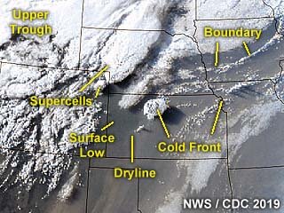
Above: Annotated satellite image showing convective evolution and the synoptic setup during the afternoon of May 27, 2019. The supercell storms of interest are in an area anywhere from Fort Morgan, Colorado, and eastward through Holyoke and near Imperial, Nebraska late in the period.
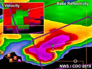
Above: Base reflectivity image of the main and powerful supercell moving out of northeast Colorado during the afternoon of May 27, and near Imperial, Nebraska. The inset shows the Doppler velocity of the storm, which was producing tornadoes and sporting a striking visual appearance at the time.
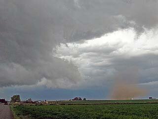
Above: A weak tornado being pushed ahead of the parent mesocyclone as the supercell becomes outflow dominant north of Brush, Colorado during the afternoon of May 27.
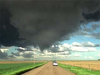
Above: A brief tornado (dust swirl barely visible left of the road and pole) forms between Yuma and Holyoke, Colorado with an impressive wall cloud / funnel late in the afternoon of May 27.
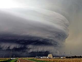
Above: Absolutely "jaw dropping" structure of the HP tornadic supercell storm near Imperial, Nebraska late in the day on May 27. Note the green "hail" color to the upper right with "stacked plates" structure, as well as a large tornado possibly on going just behind the tanks in the foreground.
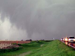
Above: Suction vortex in the HP notch / multi-vortex tornado briefly visible west of Imperial, Nebraska on May 27. The view is to the west.
Note: For DETAILS on this storm / setup as well as others in May 2019 … Please visit the link BELOW for more information!
http://www.sky-chaser.com/mwcl2019.htm#EXP19
Chase Summary: May 27 involved a change of gears to play up-slope rather than follow the area of storms already too far out of reach to the east. I targeted an area anywhere from SW Nebraska and into NE Colorado with the main area of interest being from a Holyoke to Akron line where the supercell activity should be maximized. This area was post-frontal, but had easterly up-slope flow, and a strong upper trough expected. The SPC also had this area in an enhanced risk as per their 13z and 1630z outlooks, with a 5% tornado, 30% wind, and 30% hail (significant) for the region. Another un-related area was 10% significant tornado outlooks farther east from Illinois through Ohio. I headed out of Goodland, taking SR 27 north to Highway 34 near Haigier, NE and west on there to Yuma for lunch. I continued west on Highway 34, encountering the first tornadic supercell near Fort Morgan and Brush by early afternoon. After this storm became outflow dominant, I targeted a more discrete cell back towards the Otis / Yuma area, following that northeast near SR 59 and Highway 6 east past Holyoke and into Chase County, Nebraska to near Imperial. Tornadoes were observed with this powerful supercell storm. The SPC also issued Mesoscale Discussion 833 and subsequent tornado watch box 264, valid until 9 PM MDT (10 PM CDT). The chase was wrapped up with a track north on SR 61 in a "soft spot" behind the main supercell as it was weakening. This was to SR 23 east, then SR 25 north to I-80, and finally into North Platte, NE for the night.
Storm Interception Details Are Below
1). May 27, 2:00 PM - Interception, observation, and indirect penetration of a very severe and tornadic thunderstorm to the north of Fort Morgan, Colorado in Morgan County, and north of I-76 / Highway 34 and SR 71 near Brush. The storm was a supercell storm that developed slowly and earlier north of the Palmer Divide to the southwest and moved into the area, before becoming HP and outflow dominant. The storm produced a couple of brief tornadoes / gustnadoes as it was north of Brush. These were observed at close range, with swirling clouds of dust before RFD surged out. The storm core was not directly penetrated. Small hail, frequent lightning, moderate rains, and frequent lightning was also observed with this storm. Conditions causing the storms were surface heating, up-slope wind flow, boundary interactions, a low pressure trough, and an upper trough. Documentation was digital stills and HD video. A 2016 Jeep Wrangler was used to chase the storm. A tornado watch was also valid for the area until 9 PM MDT (10 PM CDT).
2). May 27, 8:00 PM - Observation and indirect penetration of an extremely severe and tornadic thunderstorm from its point of initiation south of Otis / Yuma Colorado, and northeastward near and south of Holyoke in Yuma County near SR 59 and Highway 34, and northeastward to along Highway 6 into Chase County, Nebraska to near Imperial. The storm began as a convective shower, then grew into an LP to classic supercell with a high base north of Yuma, Colorado. As the storm intensified as per intensification of the low level jet and arrival of upper level support, the storm became a violent HP supercell as it entered Chase County, Nebraska. This supercell produced a brief tornado just south of Phillips County, Colorado. The storm core was indirectly penetrated, but hail up to 2 inches was observed. Frequent lightning with some close hits, torrential rains, and winds over 70 MPH were encountered with this storm. The supercell also produced a large multi-vortex tornado, with low contrast, visible in the HP "notch" of the storm. This supercell had an impressive and striking visual appearance, with the forward flank exhibiting powerful inflow banding / stream-wise vorticity "rotor" as well as multiple striations and "stacked plates" vertical structure. Inflow winds gusting to near 50 MPH were encountered. The RFD region of this storm was penetrated, with a brief view of the tornadic area to the north, while standing in 70 to 80 MPH RFD winds. Conditions causing the storms were surface heating, up-slope wind flow, boundary interactions, a low pressure trough, and an upper trough. Documentation was digital stills and HD video. A 2016 Jeep Wrangler was used to chase the storm. A tornado watch was also valid for the area until 9 PM MDT (10 PM CDT).
Video Of Storm Evolution (With Music) Can Be Seen Below
Pictures For May 27, 2019 Are Below

Above: Annotated satellite image showing convective evolution and the synoptic setup during the afternoon of May 27, 2019. The supercell storms of interest are in an area anywhere from Fort Morgan, Colorado, and eastward through Holyoke and near Imperial, Nebraska late in the period.

Above: Base reflectivity image of the main and powerful supercell moving out of northeast Colorado during the afternoon of May 27, and near Imperial, Nebraska. The inset shows the Doppler velocity of the storm, which was producing tornadoes and sporting a striking visual appearance at the time.

Above: A weak tornado being pushed ahead of the parent mesocyclone as the supercell becomes outflow dominant north of Brush, Colorado during the afternoon of May 27.

Above: A brief tornado (dust swirl barely visible left of the road and pole) forms between Yuma and Holyoke, Colorado with an impressive wall cloud / funnel late in the afternoon of May 27.

Above: Absolutely "jaw dropping" structure of the HP tornadic supercell storm near Imperial, Nebraska late in the day on May 27. Note the green "hail" color to the upper right with "stacked plates" structure, as well as a large tornado possibly on going just behind the tanks in the foreground.

Above: Suction vortex in the HP notch / multi-vortex tornado briefly visible west of Imperial, Nebraska on May 27. The view is to the west.
Note: For DETAILS on this storm / setup as well as others in May 2019 … Please visit the link BELOW for more information!
http://www.sky-chaser.com/mwcl2019.htm#EXP19
Last edited:
