4/29/22 EVENT: NE/OK/KS

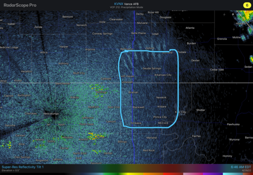
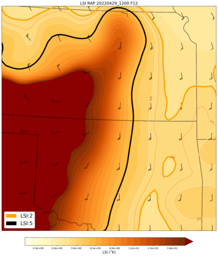
This would be my general target area for a dryline play, if I were able to chase today, but unfortunately I will instead be watching from PA, if I even have an opportunity given professional commitments today and personal commitments tonight… Model runs appear to have maintained consistency since this time yesterday. Still some concerns about shallowness of moisture so will be interesting to see this morning’s soundings. Either way 850 dews look better at 21z than at 0z so there should be a couple interesting hours this evening. If I were actually chasing I would be looking for reasons to be in the KS area of the target due to much better roads/terrain than in the OK portion.
 

Attachments

  • A6B36877-C7ED-4654-B64C-13B577382603.png
    A6B36877-C7ED-4654-B64C-13B577382603.png
    2.6 MB · Views: 0
I am already smack in the enhanced area sitting here at the house. They scheduled baseball practice tonight so that may inhibit my ability to get where i want. May have to be a local chase which is alright too. However my target was going to be the Ark City/Winfield area in KS.
 
The cap looks very breakable this afternoon, based on this Lid Strength Index (LSI) analysis. I am planning to be out this afternoon. (LSI is for 12Z 12-hr RAP forecast .)
 

Attachments

  • RAP_LSI_20220429_1200_F12_20220429_1103.png
    RAP_LSI_20220429_1200_F12_20220429_1103.png
    295.6 KB · Views: 0
Outflow OFB in Kansas remains distinct from the Nebraska warm front WF. Great things happen in northern Kansas this time of year, late April early May, with less than late May parameters. Tescott 1 and 2 anybody?

The said boundary layer issues might be overcome easier in Kansas than in Nebraska, with dews in the 60s and temps rising quickly. CAPE will be robust on the OFB. Could recover WF, but I'm an OFB chaser when it's available (cap still breachable). Per @Mike Smith post earlier this week, morning rain indeed verified in northeast Kansas. Rate of destabilization and local SRH will be in place there.

So I wish I'm eating lunch in Topeka (not adulting in Tenn.) with option to go west or northwest. Junction City or MHK have unique road options out, so it depends on nowcast. Ft. Riley is in the population weighted center of all that; so, not an easy place to move from quickly. JC or MHK work better.

One could also set up farther north along US-36 or K-16 if the OFB moves north, which it probably will somewhat. US-36 (farther north of the two) would offer last-minute Nebraska WF target; however, I really like Kansas.

Sorry I did not discuss down the DL into southern Kansas or Oklahoma. Obviously a lone beast could do things, but I like boundary intersections.

Good luck to everyone and chase safely!
 
Love it Jeff... Chase Safely!!!

Cannot be emphasized enough. I think ideally a chase team needs a crew of at least 3 (three). 1 driver whose sole focus is the road. 1 navigator whose sole focus is keeping you out of harms way with good directions. And lastly, 1 observer that keeps his eyes on the storm to make sure you are a safe distance away.

If you chase like this, you should be able to stay safe. And of course please pull off to the side of the road when you make a stop.

Remember... when it comes to car vs man, the car is going to win. Do this for your own safety!!!
 
Missing all the action out here in PA, my wife and I were out to dinner with another couple, and I was frequently checking RadarScope on my iPhone…. Couldn’t believe the separation between this velocity couplet and the precip on the Andover/Augusta storm and knew it had to be a highly-visible tornado… Sure enough:


A certain well-known chaser had some great footage also, but his screaming like a lunatic, despite his own suggestion that we listen to the roar, makes me hesitant to post it, so those interested can go find it… Goes through a red light too… Can’t say I wouldn't do the same thing in that situation, but it’s another reminder you need to be careful out there and expect the unexpected on the roads…

Looking forward to seeing chase reports from some of our own here on ST!

This could end up being the tornado of the year from a photogenic standpoint… Especially the combination of beauty and violence… Another lesson that as bad as one thinks a season is looking from a meteorological standpoint (see State of the Chase Season 2022 ) it only takes one day like this to make it a year or even a chase career… Just hope the atmosphere has enough left for me when I get out there in three weeks!
 

Attachments

  • 82BF8AB4-E9A4-49A1-8ADD-C68CF8757DC6.jpeg
    82BF8AB4-E9A4-49A1-8ADD-C68CF8757DC6.jpeg
    185.1 KB · Views: 0
Somewhat incredible that a strong tornado plowed through a populated area and very few injuries with only 1 serious injury. Some incredible videos out there.

Regarding the famous chaser driving about 30 seconds into the video he goes the wrong way through a roundabout with a car coming from the other direction it appears. His drone video is awesome.
 
Hearing some reports of "students" / "chasers" involved in a "major" highway accident last night while returning from chasing. Hope they are OK. Saw some red light running yesterday on multiple videos.
 
James: The separation was perhaps the most pronounced I have ever seen. What made it especially unusual was the separation existed from the very start of the rotation.

As to Matt's comment about the lack of serious injuries: I believe the forecast and warning system worked very well yesterday.

You might find this to be of interest: Unfortunately, The Forecast Was Correct I'd like to direct your attention to the tornado spinning up in the foreground with the Andover Tornado's supercell in the background.
 
One thing I noted, the horseshoe updraft with the RFD wrap apparently completed encircled the
mesocyclone/tornado cyclone at one point best I can tell I came across a panoramic shot of
the supercell and the clear shot was all the way around the tornado, but it was still upright and not
fully occluded yet. I don't think I have ever seen that. Is this what actually happned give the tornado was so isolated from the main precip core? I can't locat the panoramic pix in question, but you can
kind of see it here. First and second photo at the top.
 
Also, does anyone have a 3D volumetric scan of the LP supercell? I saw one that really caught my eye (and again, can't locate it on Twitter!). It basically showed this rather narrow tube (yellow - about 35 dBz) where the mesocyclone was amazingly isolated from any precip around it. The tube stating to arc as it went up and connected sideways into the main precip core to the E. I can't recall a 3D volumetric scan of a tornadc mesocyclone quite like that before.
 
Back
Top