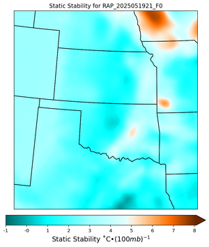
• While Stormtrack has discontinued its hosting of SpotterNetwork support on the forums, keep in mind that support for SpotterNetwork issues is available by emailing [email protected].

2025-05-19 EVENT: KS/OK/TX/MO/AR

I also gave up. Right as my last appointment was over several attempts at convection started SW of Emporia along the turnpike and I thought "Oh boy here we go". They quickly fizzled. A storm eventually materialized in SW Lyon County with some brief rotation but nothing to write home about. Nothing else of note within a drive. It appeared a quick QLCS tornado perhaps up by Eskridge but that would've been difficult to forecast or see. It hasn't even rained here at the house, and we need the rain.
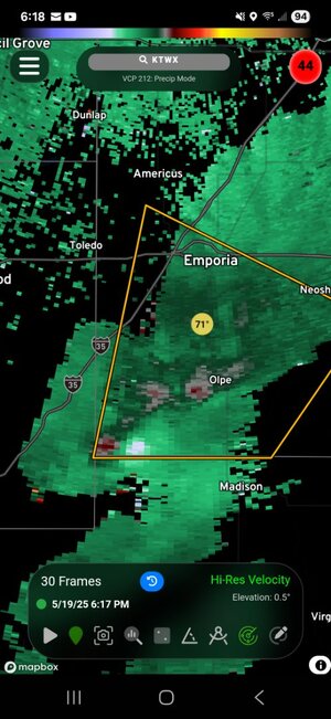
Screenshot_20250519_181823_RadarOmega.jpg
 
Another stupid day. Tried to intercept cells coming across the Red River that were briefly discrete but quickly went linear and grew upscale. Messed around helplessly in the Ardmore/Marietta region with non-descript embedded cells in the line, futilely hoping for a clear meso or reversion to discrete mode. Despite a couple brief tornado warnings, it was not to be. Should have bailed way earlier but it was the last day of the trip and at least was just 90 minutes from DFW so we gave it the ol’ college try until about 7pm. No good visuals at all today, nothing I couldn’t see in a garden-variety Philadelphia-area thunderstorm.
 
Add me to the list of people who gave up early. Saw a briefly promising cell pop up near Pawnee and chased it up toward Ralston, where it pretty much died. Then did a complete circle around the storm that went through OKC and Stillwater and expanded into a big cluster. Saw nothing of interest. I had kept waiting for something to happen along the dryline, but that was it. I think the dryline may have stayed too diffuse, never tightening up enough to get good storms going.
 
The winner was the surface low in east-central NE. I think that is the only target that produced a photogenic tornado, at least from what I see with a quick scroll on Twitter. I avoided a bust today (barely) along the KS/NE border, but I thought the day would go so much better than it did. The worst was seeing what looked like an imminent "night of the twisters" in St. Louis while I was still 4 hours away. Thankfully these appeared to be spinning up on a boundary south of the metro that never did move any farther north. Nothing in the immediate metro area anyway.
 
Last edited:
Yesterday has to be considered a colossal bust, considering the large hatched tornado risk, and there were only five tornado reports. There were too many storms, and something else was off, too. This is a good case for future study. And then we go quiet until Friday, maybe a "death ridge?"
 
Just my opinion, but the main issues I saw with yesterday (and also the 4/28 setup) were the low level hodos. Either models got things slightly wrong or in some cases were correct in predicting some kind of lack of veering or veer-back-veer profiles in the 0-2km level which, even with all other factors nearly perfect, tends to result in messy mode including splitting, storm interference, and subsequent lack of updraft organization/maturation.
 
What I noticed was the RAP and NAM were showing ENE storm motions and a lot of the storms ended up with NE or NNE storm motions. With southern surface winds, that wasn't going to do it. The main jet seemed to come in at a little different angle than the models depicted or I'm stupid af. Either way, that was a major forecast bust for myself for a day that looked great for almost a week or more.
 
The other thing that was evident to me, besides the overly diffuse dryline, was that with the exception of when I got on the east side of the storm that went through OKC and Stillwater, I was in southwest or SSW winds all day. Never anything with an easterly component except for the cool outflow from the storms to the southeast, and only east of the OKC/Stillwater storm So not much directional shear where the instability was better, especially considering the storm motions Ben mentions. I think that OKC/Stillwater storm, and other storm attempts near it, went up more so on outflow boundaries from the MCS to the southeast than anything related to the dryline, such as it was. Aside from weak storms later on the cold front, there were NO storms at all anywhere north of I-40 and west of )-35 except in the immediate OKC area, despite the presence of very high CAPE.
 
It never works out with veered winds ahead of the dryline. RAP and NAM depicted a tight moisture gradient near the Red River, which seems incongruent with the mixing that occurs when winds are veered ahead of the dryline. IIRC, models showed slight backing in that region later; perhaps that would have been the case, had storms not initiated as early as they did?
 
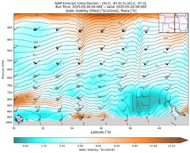
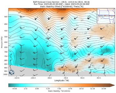
One thing I did notice was the boundary layer ahead of the forecast 21Z-00Z dryline position in OK became very stable; I assume this was due to outflow from storms to the south and east, but most especially due to the left-moving cell that moved through Stillwater. The area of interest is between 33˚N and 38˚N in the NS cross-section and -98˚W and -94˚W in the EW cross-section:

NAM_Fcst_SS_20250520_0000_F00_20250521_1019.jpgNAM_Fcst_SS_20250520_0000_F00_20250520_1335.jpg
May 20, 2025 NAM 00Z Analysis: NS Cross-Section of Static Stability through LON=-97˚WMay 20, 2025 NAM 00Z Analysis: EW Cross-Section of Static Stability through LAT=36˚N

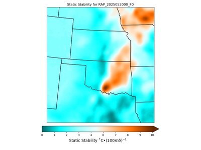
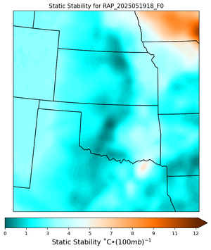
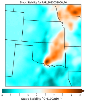
The area between 34˚N and 37˚N did not fire any dryline storms at all during the day, but storms in KS and TX outside that zone of latitudes did form. To check that out I computed the 00Z mean static stability over the bottom 125 mb and mapped it spatially. By this time the dryline was between Enid and I-35.

It seems clear (at least to me) that the lower atmosphere between E-OK and the dryline has been stabilized and the only cause for this that I can imagine is thunderstorm outflow. Note: this calculation assumes the critical value used to characterize stability of EML (4.5˚/100mb, the "white" part of the colormap ) applies here but I have not looked into this so is it's an on-the-fly guess.

RAP_SS_dev1.jpg
Static Stability of Lowest 125mb of Atmosphere computed using RAP Analysis Output for May 20, 2025 at 00Z.


It's worth noting that the outflow boundary put out by the "Stillwater Cell" did not initiate significant convection (not shown). Not sure if I will write-up this obvious bust because I have been trying to push out a software package for the past month and was forced into the field by this "Can't Miss Event". 🤔
 
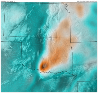
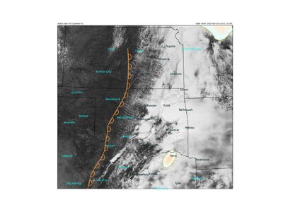
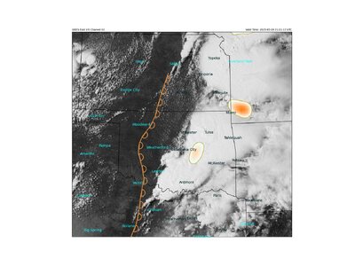
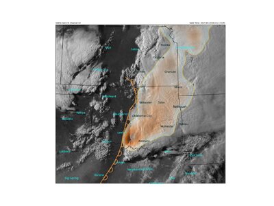
I would love to see this overlaid onto a Vis satellite image with radar and surface obs. timed out for like 3hrs from 20Z on.
Something like this?

I'll have to play around with it because now that I see a superposition, I wonder where on this map is the actual dryline. Maybe I will write this up and try to make some sense of my observations from the ground. And of course then adding in the Nexrad data and still make it all visually appealing.

One issue will be the fact that the RAP damps out the Static Stability signal: it is strongest in the analysis (F00) run and then washes out with each successive hourly prediction, so there is a herky-jerky character to the time series analysis. (At least for this case which is the first time I have looked at low-level mean static stability.)

TLDR: the graphic analysis will probably be 3-hourly and not hourly.

1747864744678.png
Superposition of low-level mean static stability on
GOES-E Visible Channel 2 for 5/20/2025 00Z.​
 
Back
Top