2024-06-15 EVENT: NE/SD/KS/IA

Joined
Jan 14, 2011
Messages
3,229
Location
St. Louis
Since we're within 6 days and it's been quiet for some time now, I thought it would be good to start a discussion on this setup. Medium-range models and ensembles have come into in decent agreement and consistency over the past couple of days on a shortwave trough ejecting into the central/northern Plains on Saturday, June 15. The synoptics look good, a 40kt+ midlevel jet max over 65-70F dewpoints, an arcing dryline and a breakable cap all the way down into Kansas. The Euro is off on the timing a little, but the sweet spot looks to be along/north of a dryline bulge somewhere between southeastern South Dakota or eastern Nebraska. Wave timing looks to be the main concern with such a small feature, but this is on my radar now for a possible trip.
 
I could have still been out there working remotely and chasing when applicable, but I came home Wednesday 6/5 due to the unfavorable pattern. Saturday 6/15 was my return day no matter what - need to get home for Fathers Day on Sunday. So I can’t chase on Saturday. This seems to happen every single year, things light up right after I get home, or right after my last outside date to chase. Maybe I should say, screw it, I should be able to do what I want on Fathers Day, and come out and chase LOL. But I can’t, the reality is it’s a family day, and it might even be hard to get home on Sunday depending on where Saturday’s final target is…
 
The good news in that regard is it looks like this is a one-and-done system, possibly the final one of the central Plains season which otherwise looked like it was already over. There is a lot of time for it to tank before next weekend, which since I posted this thread, will probably happen on the 00z runs tonight!
 
The latest run of the NAM shows potential near the NW corner of Iowa. Forecast sounding for 2100z shows a strong level of CINH in conjunction with 1,000 CAPE and 350+ 0-1km helicity. GFS, Gem GDPS, and the NAM all have convective precip moving into that area by 0000z with a meso low. Future runs will be interesting to watch especially as some of the CAMs come into range.

I'm currently on vacation until next Sat, and had tentatively schedule the time over a year ago in anticipation of making a Plains trip, but now I'm on the fence about pulling the trigger. The lack of obvious setups that's been forecasted for the past week or so really put a damper on the whole idea. While this looks tempting, and I'm sure there will be at least another opportunity next week (Thurs- with surprises in between), I don't think it's enough to lure me into a 2,700 mile trip. Complicating things further is the fact that my wife, who would also like to go, doesn't start her vacation till Fri night. The 20 hour drive is doable, but cutting it closer than I'd like for my first Plains chase. I guess the final decision will depend on how things shape up in the next 24 hours.
 
I think there is some potential there, but the morning convection has the potential to muck things up. I like the look of things in SE Nebraska where the atmosphere will have more time to recover. But I don't feel confident enough to recommend such a big drive.

RST
 
The main wave now looks to come in very early, triggering overnight/early day storms as Robert said. Those could potentially hose everything, but also potentially provide a nice outflow boundary. The ambient wind profiles look great between 22z-03z in eastern Nebraska and southwestern Iowa and the moisture is there, it looks like it will come down to the specifics of the wave timing/configuration. CAMs have been weird about feature/storm placement. Whether it will bring me out of my 2024 season retirement will be a question for early tomorrow morning. It's about a 7-hour drive from here, so I can make it if I left after the first few visible satellite frames of the day,
 
This one is a no-go for me. I don’t like the extent of cloud cover, the persistence of the southwest flank of the morning MCS, questionable storm mode and the pretty consistent depiction of storms struggling with capping. I don’t doubt that there will be a couple of tornadoes, maybe even a quality one, but it’s just too far (7+ hours) for me to bite on something that’s not a slam dunk at this point in my season.
 
Last edited:
The OFB in KS is hard to ignore and the HRRR is picking up on it with storms near the KS/NE line later. I have been thinking about a multi-day chase but now might just drive north of KC a bit and chase that OFB.
 
That outflow boundary with Cu already bubbling is like a beacon to chasers, showing so clearly on visible satellite. Doesn’t seem to be moving much, wondering if it doesn’t lift as far north and ends up with a tornadic storm on it in the KC metro. CAMs and Nadocast haven’t been buying into that idea, but it’s got me contemplating going west to be there in case it happens. My hesitation is the madness that is I-70 traffic in Missouri during the day.
 
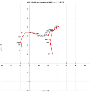
Sitting just north of Hebron NE. Got excited last night around 2a and got my butt out of bed and up to Nebraska. The OAX VAD Hodograph is pretty stellar. The outflow boundary looks good and this bubbling cu and small storm to my south looks pretty good.


hodo (6).png

Morning Topeka sounding showed a MeanW of 15.2 and we're somewhat in the low 80s over low 70s with extremely backed winds here in Southern Nebraska. On water vapor, you can see a decent southsouthwest to northnortheast bullet coming out of Kansas. I'm expecting something very nice on that here in the next couple hours.
 
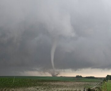
A tornado watch has been issued for that area until 10pm.

We've already had severe thunderstorm (downburst) warnings in south central Kansas. KHUT just clocked a gust of 77 mph!

Happy -- and safe -- hunting!!

Addition at 4:20pm, a second report of 77 mph winds 3 mi southwest of Salina.
 
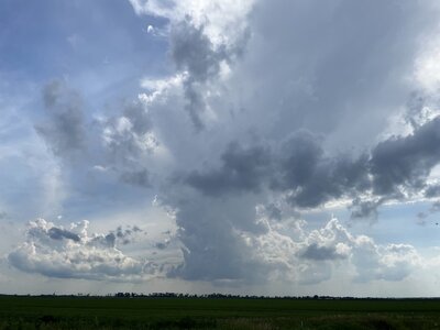
A few attempts here northeast of Kansas City, but so far just narrow updrafts that quickly orphan their anvils after about 30 minutes. In Lexington, MO at the moment, will stick with the boundary through the evening and see if anything can get going. Not optimistic, but will hold out until nightfall. A couple of sunset bolts would be nice. Only 3.5 hours from home, so an out-and-back day at worst.

IMG_2066.jpeg
 
Back
Top