2024-05-25 EVENT: OK/KS/TX/MO/AR

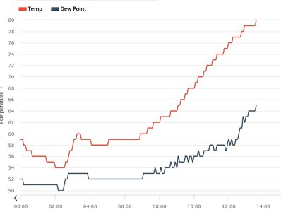
Based on the mesoanalysis and surface ob trends, I can't see how the good moisture doesn't make it to I-40 if not farther. I don't know why the CAMs have been so finicky about developing storms north of the Red River. Is there any real-world thing to support this that I'm missing? Some special soundings to sample the moisture depth upstream would be nice soon.
 
All morning I have been debating on whether or not to commit south of the Red River, or north of it. With the very meh road network either side of the state line, and being limited by river crossings, I figure whichever side I end up on will likely be the side I stay on. I agree with Dan about moisture making it to I-40, and for what its worth the 16z HRRR is starting to indicate storms firing farther north into west OK as well, though there has been next to no run-to-run consistency on that. Having said all of that, my current thoughts are to target somewhere north of the Red River along a N-S running highway. I want to be able to adjust if necessary. I'm thinking maybe US-183 near Snyder, but even as I type this I'm second guessing. Luckily being so close to the target area, I have a little bit more time before I have to commit one way or the other.
 
Nine CAM's offering nine different solutions with each run. Moisture return looks to make it to the Kansas border with 66-67 dews in Enid now, although as Dan mentioned the quality of depth is questionable. Still enough juice for anything to happen depending on when and where the cap decides to break.

Still looking at making a center field type play just west of OKC and I can go north or south from there. Will be watching visible satellite closely today for developing CU fields. My gut tells me storms will try to fire around 4pm even though CAM's are holding off until 6pm or later. I've seen numerous times this season where storms popped well ahead of model expectations and can easily see that happening today as well.

Haven't left the house yet and will probably hold off for another hour or so to let things develop a bit.

Edit: Normally I'd start today somewhere around Wichita Falls/Lawton area but it's a Moderate Risk on a Saturday in May in Oklahoma and I'm assuming the hordes will be out in force, so I'm very open to alternative targets today.
 
Per the cirrus streaming across the Texas panhandle, it looks like the jet max may already be overspreading the dryline. Models don't have that completely departing by 00z, but I wonder if CAMs think there will be subsidence issues by then.
 
I'm interested in that little boundary that seems to be running across DFW metro in a southeast-northwest orientation and seems to pull back into the dryline at the tip of the best Theta-E. Sure looks like we'll be in Southwest OK This afternoon.current.THTE.grad (2).png
 
Well, sports fans, the 12Z HRRR forecast a surface dew point of 49°F at Wichita at 1pm. Actual Td at KICT? 60°F!

Ten minutes ago, there were no cumulus in the sky. Now, we have three very small Cu to our southwest (I live in far NE ICT).
NW Wichita dewpoint has went from 52 at 7am to 65 at 135pm. In the last hour has went from 58 to 65.
 

Attachments

  • dewpoint.jpg
    dewpoint.jpg
    49.5 KB · Views: 5
Dew point went from 56 to 64 here in fairly short order once the wind went from ESE to SSE. Still unsure on quality, but we have more time to keep pumping it north before initiation.
 
Totally agree with Mike Smith and couple other moisture posts, you don't need 70s dp to get great storms..they help with lower LCLs but there plenty of dynamics that make up for it ..making my way out towards medicine lodge, greensburg and let whatever happen happen!
 
The early wave has already fired storms well south of the Red River. These appear to be in line to cut off downstream inflow. Also, the cirrus deck to the north is very thick and is stunting further destabilization.

13Z SPC had explicitly mentioned the extent of TX convection as a factor in the risk in OK. Interesting that SPC is treating NW TX and OK as separate regimes (per 16:30 outlook and the NW TX MSD). Initiation in NW TX began at ~2pm, earlier than the “late afternoon” forecast in the 16:30 outlook.

We are nearing Altus and are going to head south for the northernmost storm heading toward Vernon. Can’t just ignore that given the environment (note it’s already out of the NW TX watch box) but will keep an eye on new development back in SW OK.
 
The western side of that cluster of storms south of the Red River has cleared out enough that I now don't think it is much of a threat to the areas farther north. Cirrus clearing out for a bit in SW OK. In Lawton, final decision time soon on south or northwest.
 
Back
Top