Dan Robinson
EF5
Storms to the south of Lawton have sent a lot of cloud debris north. Also seeing some outflow evident moving westward and northward from them. Committing to southern storm.
Last edited:


Any chance you mean Anthony, Kansas?Anthony , OK
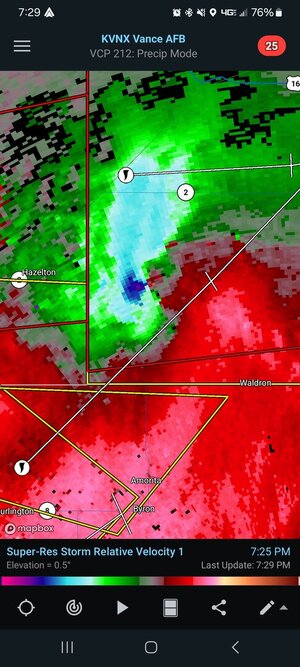
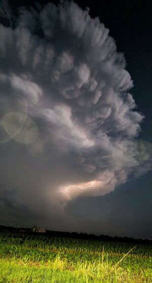
Hahah yes !!! Forgot I crossed the border.. that cell looked anemic until that one merger ..and then it went gangbusters right where I was at ..and it went rain wrapped super fast after the pics were taken. I got 80kt RFD.. then it disappeared as I went south but looked like this on radarAny chance you mean Anthony, Kansas?
Regardless, those are terrific photos!
Yeah I messed around doing that last night ..the light show was great.. I didn't expose this one long enough for better lightning and had some contamination from a street light . But it was great to watch.Things have gotten interesting again. The SPC has issued a Tornado watch for eastern KS and WRN Mo until 5 am CDT. Heading up I-35 towards KC and the lightning show is absolutely insane right now but the wind is pushing then car all over the place. Hoping to find a dry spot to do some lightning photography.
You were either right behind me or right in front of me. I had a great look back to the west. There had to of been 40-45kt inflow from the east. At one point I looked over and thought I saw a funnel starting to come down so I slowed down and came to a stop to grab a picture but it went back up before I could.Hahah yes !!! Forgot I crossed the border.. that cell looked anemic until that one merger ..and then it went gangbusters right where I was at ..and it went rain wrapped super fast after the pics were taken. I got 80kt RFD.. then it disappeared as I went south but looked like this on radar
hahaha that's too funny. My Spotter Network name is JayPatton. I am down in Dumas now, gonna see what happens over the next couple days over W TX Amarillo to Lubbock watching some outflow based stuff. particularly on the 28-30th. I think it will be more structure over tornadoes, but still fun for some pics.You were either right behind me or right in front of me. I had a great look back to the west. There had to of been 40-45kt inflow from the east. At one point I looked over and thought I saw a funnel starting to come down so I slowed down and came to a stop to grab a picture but it went back up before I could.
Agree andy.. I think it would be interesting to go back to the 23rd, 24th, and pull models to compare the actual radar from the event, do some digging into what some of the models runs missed and what verified.. I know for me. I stuck to the cold and hot runs only up til 24hrs prior, and I saw more trends that ended up verifying at least initially, but not the entire evolution, but I find for me that's what tends to work more often and it's by no means perfect either. But I wonder if the sfc low trajectory and the moisture plume shape had something to do with it . The models tended to eject it NE across nrn KS , but I wonder if it went further east instead increasing the sfc convergence.. also at times the speed of cells were easily 50kts . I had a hell of a time keeping up with the Anthony cell..which I started chasing in Buffalo, lolI've never seen an event go from the biggest question mark (particularly regarding SPC and their decision to go for a high risk or not) being a cap bust/lack of storm coverage; to complex storm interactions and outflow in essentially one outlook cycle. They were wise to hold back from it given those uncertainties, but IMO justified with the 15# MDT/PDS watch given the parameters; and what ended up happening overnight despite a large chunk of Oklahoma being void of severe reports.