• A friendly and periodic reminder of the rules we use for fostering high SNR and quality conversation and interaction at Stormtrack: Forum rules

    P.S. - Nothing specific happened to prompt this message! No one is in trouble, there are no flame wars in effect, nor any inappropriate conversation ongoing. This is being posted sitewide as a casual refresher.

2024-04-27 EVENT: TX/OK/KS/MO/IA

Joined
Jan 7, 2006
Messages
621
Location
Oklahoma
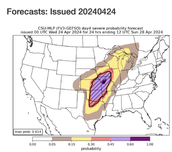
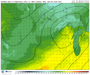
Following an impressive but questionably timed synoptic wave on Thu-Fri, a slightly more compact shortwave is forecast to eject into the southern Plains sometime on Saturday. Given how closely spaced these two systems are, there is still considerable uncertainty regarding all aspects of the second wave (timing, geometry, etc.) -- more so than is perhaps typical at 120-h lead time these days.

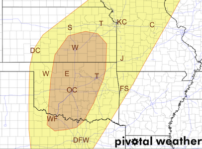
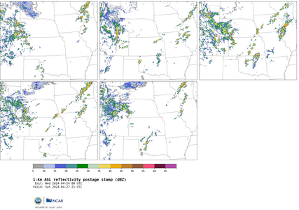
Despite a somewhat wide envelope of NWP solutions right now, I would still say Saturday looks like the most slam dunk tornado setup for the Plains (not necessarily nationally, though) out of the upcoming sequence late this week into the weekend. Although diurnal timing may once again be less than ideal, in this case it's more on the early side: there's a fairly widespread signal for CI by 18z over portions of OK and/or N TX.

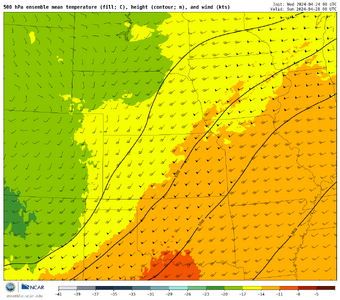
However, to my eye, the potential messiness and early CI of this setup calls into question its chaseability more than its capacity to produce tornado reports. Most guidance currently depicts a compact, negative-tilt shortwave with 60-kt SW flow streaking over a warm sector with a 40-50 kt LLJ by early evening. Unless the overall synoptic evolution changes considerably, at least a handful of tornadoes are virtually guaranteed with that type of setup in late April, whether they're highly visible or not.

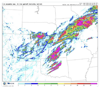
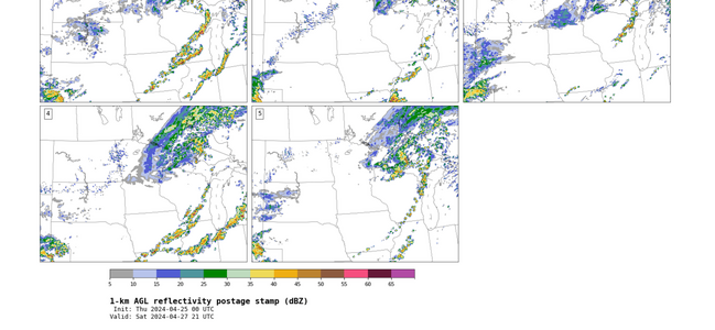
From a chasing perspective, I can imagine something vaguely reminiscent of a day like the 2015-05-16 Elmer, OK, event. That is not to say that such an intense, long-lived tornado is guaranteed; I'm talking more about the early, widespread CI, requiring patience and finding the needle in the haystack among lots of junky ongoing storms elsewhere along the dryline. To me, that scenario is sort of the middle ground right now: I can also imagine morning convection being so detrimental that it really kneecaps the whole setup at one extreme, all the way up to and including a significant regional tornado outbreak if the timing slows down and early convection is less problematic than the current median solution (the GDPS, and perhaps UKMET, are closer to this right now).
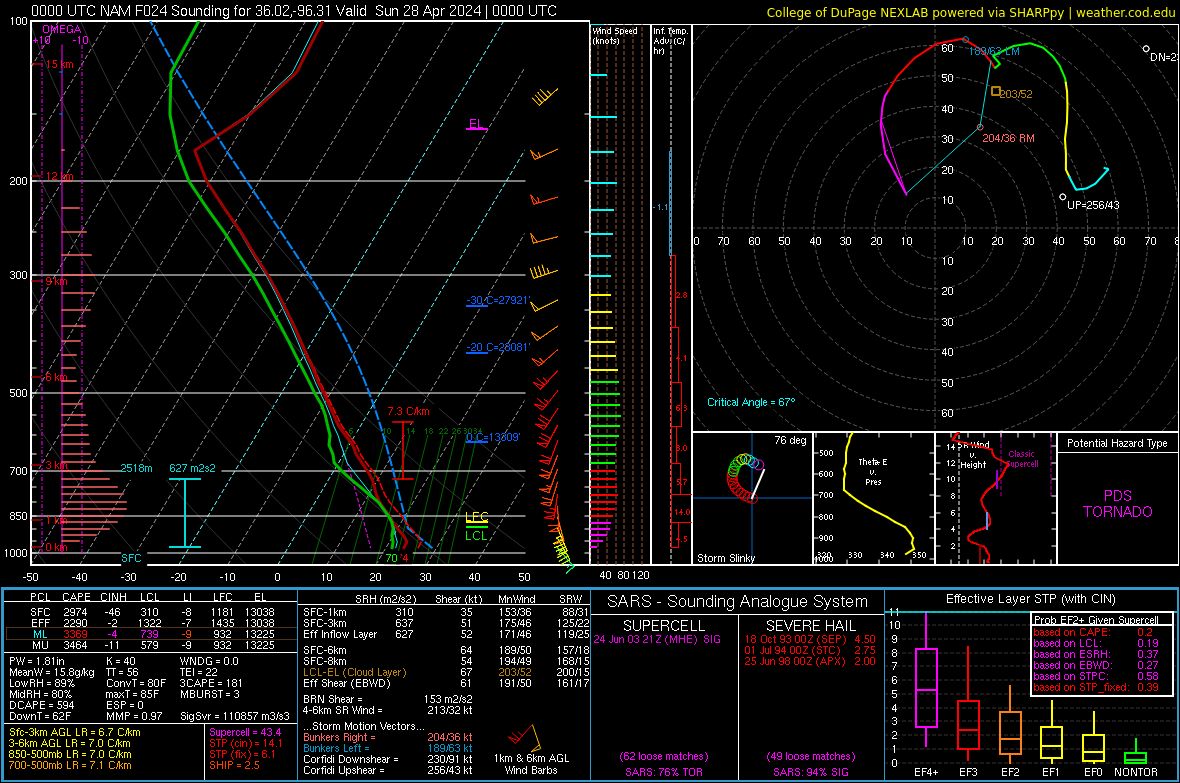
 
The great thing about Saturday is all kinds of outflow boundaries will be around. Surface will be a target rich environment.

Upper levels check out at this time, Tuesday looking at Saturday. I don't have much to add. Just want to agree Saturday should be a good chase day.
 
Finally really looked this over tonight on the 00Z GFS and it sure does look like a big outbreak. Pretty much can only get worse in further runs or we're going to have some incredible footage. Timing of the wave is perfect and the shape of the trough is that ski jump shape. Moisture is rich and a deepening 994mb low over sw kansas. Will be interested to see how the NAM picks things up tomorrow. Could be looking at a very busy day Saturday.
 
It has been years since I've had a "feeling of impending doom" about a severe weather situation but I have one for Saturday.

And, I had that feeling before I saw the attached combined tornado/hail/wind forecast. What I believe it is indicating is a high risk of tornados in the SPC forecast area and giant hail toward KC on the other side of the warm front.

Whatever the details, I'm very worried about Saturday.

If I were going to pick a target now, it would be Wichita.
 

Attachments

  • Screenshot 2024-04-24 at 12.40.19 PM.png
    Screenshot 2024-04-24 at 12.40.19 PM.png
    493.1 KB · Views: 49
  • Saturday 4-27-24 Day 3.png
    Saturday 4-27-24 Day 3.png
    720 KB · Views: 45
At the moment the NAM has some crazy forecast soundings at 0000z from Salina to Concordia coincident with a shortwave and left exit of the jet streak. These next few days are gonna be interesting if things verify with these big numbers.
 

Attachments

  • 20240424_224151.jpg
    20240424_224151.jpg
    251.8 KB · Views: 49
Long time no post, but I wanted to make a forecast here for my local target area. I won't be out and about the plains this weekend, and have some training for work on Saturday until about 4pm, so I am restricted to the IL/WI/IA border areas. It seems there is a risk for some frontal/prefrontal storms Saturday evening in a favorable environment, the caveat being nebulous forcing and height rises. SPC currently has the area in a slight risk and mentions all hazards across this area. Rather than just pluck soundings I wanted to see if others agree with my assessment.

Upper air: A departing 500mb trough from Friday will leave slight height rises behind on Saturday as it moves off to the Northeast, with another developing upper low across Western Kansas. Upper winds remain strong across the area, but heights slowly rise on Saturday. Euro has it at about .5 DAM/hour, and I and dumb enough to admit I don't really know if that is significant enough to cause subsidence/be hostile to storm development or not, so if anyone wants to chime in, go for it. 500h_change_012h.us_mw.png

Despite this, many models show convection across the frontal area. And the MPAS ensemble has almost every member firing storms along AND ahead of the front in IA/IL, in what I can only assume is a surface convergence zone/prefrontal trough (are they the same thing? I never really knew what constituted a surface trough).
IMG_7151.png

IMG_7149.png

Are these prefrontal storms firing simply due to the convergence and a breakable cap with a favorable environment for supercells? Euro convects, GFS does not and NAM is run to run. Those that do tend to show some storms forming by/at 0z, at the very least along the front. I posted the most recent NAM sounding below and confirmed the RFFS has quite a similar environment proved. What I can't pinpoint is if there is actually any kind of shortwave moving along the upper trough axis that will aid in storm development. Feel free to add input or corrections to my forecast. I hope I can get a nice discrete supercell out of this, perhaps a tornado if this environment is realized. I really like almost everything about this sounding.
2024042512_NAM_060_41.71,-90.86_severe_ml.png
 

Attachments

  • IMG_7150.png
    IMG_7150.png
    98.2 KB · Views: 8
  • IMG_7155.png
    IMG_7155.png
    751.1 KB · Views: 7
  • IMG_7156.png
    IMG_7156.png
    124.3 KB · Views: 3
  • IMG_7152.png
    IMG_7152.png
    106.1 KB · Views: 11
Last edited:
While there looks to be plenty of good targets at this point, I'm still liking NC Kansas as a high risk/reward scenario. There's agreement in guidance of a cell going up near the triple point with a good mix of parameters. DPs are in the low 50s on some models, and there's a risk of convection crossing the warm front early on, but I'm hoping the WF resolves further north come Sat, or the cells can latch onto the boundary.

To Brian's point, the HRRR has some leading cell going into WC Illinois with strong echo tops around 23z, but the instability and helicity seem to bottom out shortly afterwards... not sure what to make of that quite yet.
 
Am I crazy in seeing some potential downsides to tomorrow from a chasing perspective? There will no doubt be tornados, but will there be discrete storms, or will this be like one of those Dixie Alley outbreaks with clusters and embedded mesos? I admit I'm not the best forecaster (especially considering how long I've been doing this!) and I don't always have the ability to articulate my thinking in the proper technical way, but based on pattern recognition I feel like this is one of those days that stuff blows up everywhere, storms move fast, and it's a frustrating chase day. This could very well just be my personal bias as I deeply regret being unable to chase this, and if I were out there of course I would! But here are some of the things that concern me... I'm putting these out there more to learn and be proven wrong!

- The Euro, at least on last night's 0Z run (today's 12Z not available yet) does not wrap 60s dews into the triple-point. As a result, backed winds and the best directional shear is not co-located with the best moisture. Even the NAM3K has a similar look - the best moisture just not quite making it to the triple point
- Plenty of speed shear regardless, but there is a meridional component to the mid/upper flow
- Flow parallel instead of orthogonal to the dryline
- As a result, storms may move rapidly to the cool side of the front?
- As in previous events, convergence lacking further south along the dryline
- Open warm sector development appears a possibility; hard to target
- Surprising lack of modeled precip along the dryline, but plenty to the east in the open warm sector

Not hard to get TOR and PDS TOR soundings, and I'm sure there will be plenty of tornados, I'm thinking more about chase quality and ability to target with precision. There is always more downside to a setup like this. Of course you can all tell me I'm just a crazy, cantankerous old man trying to make himself feel better about not chasing LOL

(Edited to add point about flow orientation relative to dryline)
 
Last edited:
I'm waiting to see the next SPC update here in a little bit, to see where they put the slight risk at.... I'm right on the border of it for tomorrow so that will be interesting to see. Since we now have cloud cover with precipitation starting to advance on the Chicago metro area.... I do not expect it to get quite as warm today as forecast and thinking that may have an impact on tomorrow. Have a feeling I will be out though as the slight risk at current time is just barely to my west and north.
 
Am I crazy in seeing some potential downsides to tomorrow from a chasing perspective? There will no doubt be tornados, but will there be discrete storms, or will this be like one of those Dixie Alley outbreaks with clusters and embedded mesos? I admit I'm not the best forecaster (especially considering how long I've been doing this!) and I don't always have the ability to articulate my thinking in the proper technical way, but based on pattern recognition I feel like this is one of those days that stuff blows up everywhere, storms move fast, and it's a frustrating chase day. This could very well just be my personal bias as I deeply regret being unable to chase this, and if I were out there of course I would! But here are some of the things that concern me... I'm putting these out there more to learn and be proven wrong!

- The Euro, at least on last night's 0Z run (today's 12Z not available yet) does not wrap 60s dews into the triple-point. As a result, backed winds and the best directional shear is not co-located with the best moisture. Even the NAM3K has a similar look - the best moisture just not quite making it to the triple point
- Plenty of speed shear regardless, but there is a meridional component to the mid/upper flow
- As a result, storms may move rapidly to the cool side of the front?
- As in previous events, convergence lacking further south along the dryline
- Open warm sector development appears a possibility; hard to target
- Surprising lack of modeled precip along the dryline, but plenty to the east in the open warm sector

Not hard to get TOR and PDS TOR soundings, and I'm sure there will be plenty of tornados, I'm thinking more about chase quality and ability to target with precision. There is always more downside to a setup like this. Of course you can all tell me I'm just a crazy, cantankerous old man trying to make himself feel better about not chasing LOL
I don't think you're crazy at all. I'm getting concerned about messy storm modes and a lack of truly discrete cells as well. I'm off tomorrow and live in OK, so I'll definitely be chasing, but I don't really have much of an appetite for tangling with an HP mess. Hopefully a discrete storm mode will hold out longer than some models are suggesting. Even the latest SPC outlook notes that the question mark around storm mode is what is preventing them from introducing higher tornado and hail probabilities. I'm also concerned about safety. The potential for hoards of chasers mixed with messy storm modes and a very high ceiling parameter space could lead to trouble.
 
Here is my forecast: Tornado Forecast for Saturday, April 27 and I've included a special discussion for chasers and meteorologist. I'm going "high risk" on my 4-point scale. I disagree with SPC that earlier rain is a deal-breaker.

Given the fast bias, I've moved everything a bit to the west than I otherwise would.

I do agree that storms will be moving rapidly ~40 mph per AccuWeather's tool.

Good luck!!!
 
I agree with the concerns about storm mode and timing. The 12/18z CAMs are depicting a mostly uncapped environment leading up to the main event, and storm motion in some models is close to parallel to the forcing gradient, so messy mode and/or early transition to linear seems quite likely. There's a lot that could go wrong with timing too, with earlier storms forming beneath an uncapped environment before low-level shear parameters are maximized. That said, CAMs seem really all over the map to me for this event being so soon - some CAMs are quite aggressive in airmass recovery in wake of earlier storms, some CAMs like NAM barely initiate anything prior to the main event.
 
New NAM is rolling in. I was able to cherry pick the best sounding ever.

2024042700_NAM_024_36.02,-96.31_severe_ml.png
 
For all the concerns I am seeing here and elsewhere about messy storm mode and too many storms, I am beginning to have the opposite concern - quite a few of the CAMs available so far this evening are showing no storms at all along the dryline tomorrow. Not all, but several. Models do seem to be in pretty good agreement on dryline placement, from around Dodge City southward to the eastern edge of the Panhandles. If things stay as they look now, I will probably start out somewhere around Greensburg, but not overly confident right now on actually getting dryline storms. Staying in Dodge City tonight. I sat out today because at 74, driving from western KS to Omaha or Iowa and then back again was just too much. Of course since I did not chase today, that ensured there were tons of tornadoes in today's target area. Those of you who saw them, you're welcome, LOL!
 
I can't recall ever attempting to post in an EVENT thread with any more detail than "I plan to target X town", so please bear with me on this one. The CAMs seem to be coming into agreement with convection kicking off in western north TX and heading into SW OK as early as 12-15z, with some signs of it remaining discrete and robust. Both the HRRR and the NAM have some impressive parameters throughout SW OK at that time as well. This is from the 00z run of the NAM valid at 15z in SW OK.

2024042700_NAM_015_34.71,-99.30_severe_ml.png

I will be starting from home in Altus, OK, so my plan right now is to start bright and early and chase the early morning convection as it moves off to the NE. Later on around midday and into the afternoon, however, I'm still having trouble deciding on a target. Someone please correct me if I'm misinterpreting something, but on the most recent HRRR and NAM runs, both are showing the better parameters being off to the south and to the west of the OKC metro as far as instability, SRH, etc., and then pushing off to the east as the afternoon progresses. The CAMs are also showing discrete afternoon convection in that region, especially down towards the Red River. Following the morning storms, my thinking right now is to perhaps target somewhere along the I-44 or I-35 corridor, north of a line from Lawton to Wynnewood, but south of the metro. I'm sure that my plan will change again once I wake up tomorrow, and probably a million more times throughout the day, but I wanted to actually get something written down to keep myself honest and to hopefully force myself to improve my forecasting. Also, if I am mistaken on any of my above reasoning or am missing something meteorologically, please feel free to correct me!
 
In a broad sense, the setup for this one reminds me of 18 May 2017, which was a high risk bust across mainly OK. It featured a semi-compact shortwave ejecting over the plains in a manner not dissimilar to the shortwave impulse arriving tomorrow, also following right on the heels of a previous shortwave that prompted a moderate risk (success) two days prior in the same region. This particular shortwave appears to be lower in latitude by a few degrees and isn't as compact (or intense), but the low-level moisture already in place appears to be slightly better and further west.

The 2017 event was a bust primarily because storms went up really early (18Z initiation), which was before the wind profile could really "straighten out" from the typical morning spaghetti-like tangles that 12Z soundings tend to exhibit. Thus the initial storms consumed the good instability while struggling to produce tornadoes. A few longer-tracked supercells did occur, but I recall only one of them producing a photogenic tornado, and it was really only the one. There were TONS of storms, though, and competition was definitely a problem across most of the high risk area.

However, the convective scale forecast of this event differs from the May 2017 one. CAM forecasts of the May 2017 featured spatially dense and extreme UH tracks in the high risk area. Also, those forecasts did not contain a classic feature that I am seeing in the forecasts for this even - the overnight convective complex that develops over W TX between LBB and MAF (roughly 08-10Z) and then flies northeastward over NW TX and most of OK through the morning, usually departing the I-35 corridor by about 18Z. This seems to be the result of an arriving upper-level disturbance and its associated forced ascent first impinging on the very westernmost fringe of the high quality moisure, which has usually pushed back to the I-27 corridor by the overnight hours. This seems to be all it takes to fire up some strong (generally non-severe or only marginally so) storms that really push the limits on what kind of re-destabilization can occur behind it up to the northeast.

Most of the CAM runs I'm seeing (both deterministic flagships and ensemble members) indicate some degree of this evolution. The HREF is basically 100% all-in on this exact scenario. The NCAR MPAS ensemble, on the other hand, leaves TX and OK clean until afternoon CI. The NCAR C-SHiELD ensemble is more mixed, but several members are interestingly in between - firing storms near or just west of SPS around 12-13Z, which seems truly peculiar. Other members are "clean".

Some other experimental MPAS runs that NSSL are doing don't paint a great picture for chase prospects. Two of the configurations look like carbon copies of each other and are pretty pathetic:
Screenshot 2024-04-26 at 23-35-47 NSSL CAMs MPAS-HT-NSSL.pngScreenshot 2024-04-26 at 23-36-11 NSSL CAMs MPAS-HN-NSSL.png
Here's their corresponding early-day depictions:
Screenshot 2024-04-26 at 23-47-58 NSSL CAMs MPAS-HN-NSSL.pngScreenshot 2024-04-26 at 23-43-29 NSSL CAMs MPAS-HT-NSSL.png
These models tend to wipe out most of the region, but leave the fringes open for rotating storms. That basically results in a widespread mess from about I-20 to possibly as far north as I-80:
Screenshot 2024-04-26 at 23-49-53 NSSL CAMs MPAS-HN-NSSL.png
Even the experimental RRFS, which does not contain early-day convection and does develop afternoon supercells in OK, doesn't persist them for terribly long:
Screenshot 2024-04-26 at 23-36-25 NSSL CAMs RRFS-EMC.png
The RRFS does go ape-shit on the warm front, though; it is one of the few that does:
Screenshot 2024-04-26 at 23-36-55 NSSL CAMs RRFS-EMC.png

Without droning on too long, I definitely see some flies in the ointment on this setup, and I'm not surprised SPC has held off on even going moderate risk for this event. There is a lot of uncertainty as to a huge fraction of the environment being wiped out early, and also to storm coverage and location later on. If the TX overnight convection never materializes, that could imply the wave has not yet arrived, which could imply that it is late in ejecting. Thursday (the 25th) seemed to underperform a bit, and I suspect it is because the wave ejected too late. Perhaps that may have influenced the timing of this next one so that it might also arrive a bit late, and after the best destabilization has manifested.

I don't know how this will play out. But I don't see it as a slam dunk event.
 
I can't add much more than what Jeff touched on, but the SPC has now issued a moderate for C Oklahoma. I wonder if that is in response to the over performance of yesterday's events. At this point there's discrepancies with models in respect to cloud cover, but most do break out convection in C Kansas near the triple point. The last several runs of the NAM 3K have moved the low further south than my previous forecast, and shear looks less impressive, but I still like somewhere near Great Bend as a starting point.

I also wanted to point out for the newer members who might be learning from these forecasting threads (they've been a huge help in my own understanding)... when looking at forecast soundings and the Omega bar readings on the left are clearing the dashed lines, it's considered to have convective contamination. My understanding is that the parameters in the sounding aren't necessarily indicative of the surrounding atmosphere, and the user should take that into consideration when making decisions.
 
I was just watching a Convective Chronicles forecast video that was done on the morning of Friday 4/26 for both 4/26 and 4/27. Trey cited the meridional flow as a potential negative for Saturday, which I understand and had already mentioned in my own post above. But wasn't there also meridional flow yesterday the 26th? I'm assuming the low-level shear and cold core setup more than compensated for it, but I'm curious as to why Trey didn't even mention it in his forecast for 4/26. I'm just trying to make sure I understand why/when meridional flow is and isn't an issue.

 
I would think the SPC isn't swayed by pervious events, but I could be optimistic!

I am surprised that some of the CAMs are showing little going on as a check of the 09Z RAP shows quite the parameters across OK from around 18Z onwards. The MPAS experimental has been working quite well so far this year I think and the partial 12Z RT version looks promising though hasn't fully come in yet.

I'm sure I am missing something key due to relative inexperience, but given the possibilities, Central OK seems like the place to set up today.
 
I don't know the last time I was sitting under a newly issued tornado watch this early in the day, and I'm still at the computer having my morning coffee. The first half of my plan for the day remains intact, chase the morning storms to see what I can see. After that I guess we'll see what happens. I have a sort of outline in my head, but I'm going to remain flexible. Stay safe today folks!
 
As of 9am Central time I discern three obvious boundaries. Synoptic WF is north of KCMO. Clearly outflow is in southeast Kansas. Gravity wave or other OFB is down in Oklahoma south of I-40. I'm using the surface chart and early visible imagery. Dry line will punch out into these boundaries, along with perhaps other subtle boundaries.

Hodographs are not textbook, but there is plenty of turning with height. Some concerns on storm mode and movement are noted along the DL or pre-frontal trough. However there will be just enough orthogonal component. Low level shear will more than compensate for any upper hodograph kinks or extensions straight up. Pattern recognition with all those boundaries enhancing low-level shear / SRH calls for the robust outlook.
 
I can't add much more than what Jeff touched on, but the SPC has now issued a moderate for C Oklahoma. I wonder if that is in response to the over performance of yesterday's events. At this point there's discrepancies with models in respect to cloud cover, but most do break out convection in C Kansas near the triple point. The last several runs of the NAM 3K have moved the low further south than my previous forecast, and shear looks less impressive, but I still like somewhere near Great Bend as a starting point.

I also wanted to point out for the newer members who might be learning from these forecasting threads (they've been a huge help in my own understanding)... when looking at forecast soundings and the Omega bar readings on the left are clearing the dashed lines, it's considered to have convective contamination. My understanding is that the parameters in the sounding aren't necessarily indicative of the surrounding atmosphere, and the user should take that into consideration when making decisions.
I'm glad you pointed out contaminated soundings. I have seen a lot posted lately. The same is true for cherry picking soundings. I'm far from the best forecaster out there, but trends and averages (between models, over space, and over consecutive runs) have a much better utility in accurate targeting in my experience than poking about for extreme parameters in one run and relying too heavily on such results.

Back to todays setup. Semi meridional flow were a concern both yesterday and today, but both days had high low level shear and large low level instability which should mitigate to an extent that concern, as mentioned by James and others. latest runs show steering heights today moving off the southern dryline axis by at least 15 degees, which could maitain clusters or an ocassional discrete throughout OK and TX. Initial convection is demonstrating very linear behavior so far though.

Outlfow placement should be something to watch for the second round of initiation. If I could be out, I would be targeting Sayre to S of Wichita based on helicity tracks consistency on multiple runs. The entire area is saturated with instability and strong low shear, so it is just about positioning for good road network and likely initiation and track.
 
Currently in Ottawa, KS still indecisive about where to go. Central Oklahoma looks like the most solid of the targets, but being a big day on a Saturday near OKC, I'm more inclined to look for something elsewhere. The warm front along I-70 in Kansas is a possibility, but the strong northerlies on current obs makes me concerned that is going to either turn into a cold front by itself and/or get reinforced by outflow quickly to the same result. The boundary looks to be in better shape farther east, but I'm concerned about clouds and precip fouling that area. I may end up biting the bullet and going into Oklahoma like everyone else though. The current MCS doesn't look like it is going to plow east and wipe everything out (yet). I'm also considering playing the northern end in southern Kansas where the current MCS is shown potentially separating into supercells.
 
Dan are you not concerned about the storms to the South Holton moisture to the north? I just drove through Ottawa and I'm heading down to get on the Storm by Enid I feel the parameters are coming together pretty good down there as opposed to Kansas
 
Back
Top