• A friendly and periodic reminder of the rules we use for fostering high SNR and quality conversation and interaction at Stormtrack: Forum rules

    P.S. - Nothing specific happened to prompt this message! No one is in trouble, there are no flame wars in effect, nor any inappropriate conversation ongoing. This is being posted sitewide as a casual refresher.

2024-03-07 EVENT: TX/OK/KS

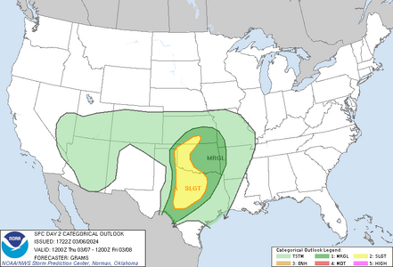
With the developing threat in TX-OK-KS tomorrow, I am opening this thread for discussion. I found the 3/6/2024 SPC Day Two Convective Outlook text product to be a bit confusing, causing me to look back and forth between the outlook and various models to 'cess out what was being discussed.

My interest (if I can get a chase partner) would primarily be along the dryline or in southern KS, with the "KS draw" for me being the forecast of elevated convection ( elevated convection --> high cloud bases --> more km of visible lightning channel). For the purpose of discussion, here is the Day 2 Categorical Outlook:
1709764648055.png
 
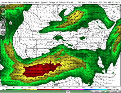
Having a look at the 06Z RAP, the strongest 500mb flow is a little removed from the areas of interest during late afternoon, though there is plenty of stronger flow.

Screenshot 2024-03-07 at 09.25.58.png

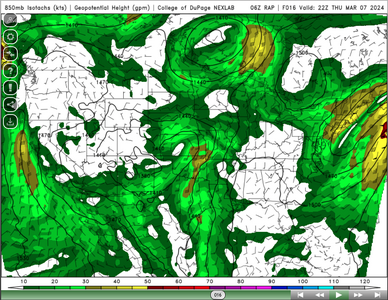
While at 850mb there is reasonable low level flow.

Screenshot 2024-03-07 at 09.26.12.png

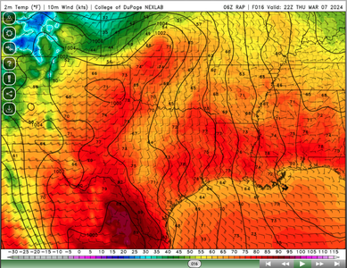
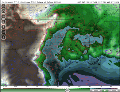
And by this time the surface low is starting to tighten up and pull mosture further north.

Screenshot 2024-03-07 at 09.24.39.png

Screenshot 2024-03-07 at 09.25.01.png

All of this seems to improve going into the evening and by 03Z the low level winds seem much more condusive for tornadoes.

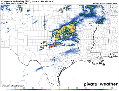
The HRRR has a couple of cells firing in TX, but most models don't seem to like much in the way of action today or tonight.

Screenshot 2024-03-07 at 09.36.37.png

There is probably plenty I am missing here, as a relative novice! I can see some possible convergance zones along the dryline which might be enough to initiate storms, but hopefully more seasoned pros can help clarify!
 
That's not a bad looking setup along the OK/KS border right now. One I'd certainly be out for if I lived within a couple of hours. Glancing overspreading of the left-exit region of the jet streak with at least 30 knots of midlevel flow. Clear skies along/south of the boundary and easterly winds just north of it. Good overlap of low-level CAPE/ surface vorticity along the boundary through the afternoon. There seems to be a broad area of east-west potential from Woodward to Bartlesville north. Any storm that goes up on that boundary will be a player as it moves just north of it. Cumulus bubbling up all along it at the moment (2PM) so it appears things will be under way soon.
 
That's not a bad looking setup along the OK/KS border right now. One I'd certainly be out for if I lived within a couple of hours. Glancing overspreading of the left-exit region of the jet streak with at least 30 knots of midlevel flow. Clear skies along/south of the boundary and easterly winds just north of it. Good overlap of low-level CAPE/ surface vorticity along the boundary through the afternoon. There seems to be a broad area of east-west potential from Woodward to Bartlesville north. Any storm that goes up on that boundary will be a player as it moves just north of it. Cumulus bubbling up all along it at the moment (2PM) so it appears things will be under way soon.
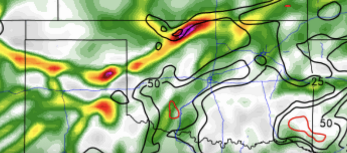
I agree--there are now MCD for both the SLGT risk polygons in the 13Z Day 1 Outlook, which were merged for the 1630Z outlook. I am trying to find a partner for south-central KS this afternoon, where the locus of 0-3km CAPE and Surface Vorticity looks reasonable:

1709841773440.png
This is a screen shot of the 18Z RAP forecast for 00Z from the College of DuPage. Not so much concerned with lightning at this point, but the potential for supercells is worth the trip.
 
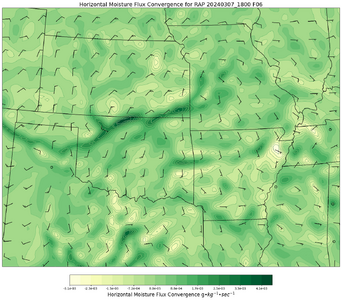
In this view, the strongest forecast moisture convergence is in N OK/S KS, and roughly coincident with the 0-3km CAPE/vorticity plot above. The dryline seems to be MIA in this representation, but I really don't know if the RAP has issues with the velocity and specific humidity fields used to compute it. (I know the CoD has a similar output, but they don't display the absolute scale and I prefer to know that.)

1709842846762.png
 
My first venture into these posts, so go easy on this novice, lol. Skies are clearing nicely in S Kansas along the border and guidance shows a pocket of instability there. Not much upper support progged, but there looks to be a play along the warm front which seems better with every model update. Winds are backed by ICT, and the appears to be an outflow boundary pushing SE past DDC currently. Probably a small window of opportunity before sunset and everything goes upscale. Should be numerous areas of interest further south, but Kansas has my attention.

Edit.... Didn't realize you guys had posted pretty much the same thing I was seeing as I typed this up, while getting ready for work, lol.
 
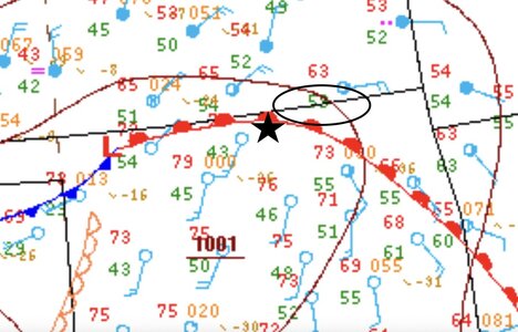
Follow-up: Not seeing any chase reports here, it seems reasonable to post a recap of the event. At least one tornado-warned supercell formed and moved roughly along the warm front in the picture below. (The star represents my target had I been able to get out for this event and the ellipse is a rough attempt to highlight the region affected by the warned cell.) A funnel cloud was reported near Caney, OK.

20240307_ROI.jpg
21Z WPC Surface Analysis for 3/7/2024​

The terrain in that area is not great for chasing, and I doubt I would have gone for the cell upon initiation, but it moved very slowly, and developed a fairly strong low-level mesocyclone shortly after a cell merger, so it was definitely a "chase-able and catch-able cell" with opportunities to get good views along the way despite the unfavorable terrain and local road network. Maybe next time....
 
Back
Top