-
While Stormtrack has discontinued its hosting of SpotterNetwork support on the forums, keep in mind that support for SpotterNetwork issues is available by emailing [email protected].
You are using an out of date browser. It may not display this or other websites correctly.
You should upgrade or use an alternative browser.
You should upgrade or use an alternative browser.
2024-04-01 EVENT: TX/OK/KS/MO
- Thread starter gdlewen
- Start date
gdlewen
EF4
Everyone has access to the model data at various websites, so I am a bit surprised no discussion so far on what looks like a significant event in the making. Even the Weather Channel has begun to hype it.
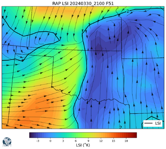
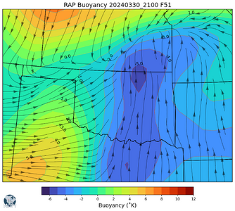
A Lid Strength Index (LSI) analysis seemed to have reasonable predictive power on 3/13, where I used it to guess at under-running as a possible reason for the lone supercell development near Stroud, OK. So here is that analysis for the 3/30/2024 21Z RAP valid 4/2/2024 00Z
I really don't think there's anything in these displays which is not available anywhere else: for example, overlaying a plot of CAP and LI should give you similar results. (Depending on how CAP is calculated, of course.)
I just hope this pattern holds--it seems to be shifting E with time.
ScottCurry
EF3
Help me understand (because I'm no expert when it comes to soundings). What am I missing???
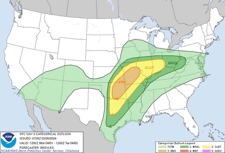
According to the SPC, for the 00Z/Tuesday run, they said, "The tornado threat may be greatest along and near a surface boundary that is forecast to extend eastward from a surface low across central and eastern Missouri. There, surface winds will be locally backed and 0-3 km storm-relative helicity is forecast to be above 400 m2/s2."
And for the 06Z/Tuesday run, they said, "Forecast soundings ahead of the surface low from 03Z to 06Z/Tuesday suggest that 0-3 km storm-relative helicity will increase into 250 to 350 m2/s2 range, as a 50 to 60 knot low-level jet strengthens. This should be favorable for tornadoes with the more dominant supercells that interact with the warm front. A potential for strong tornadoes will exist."
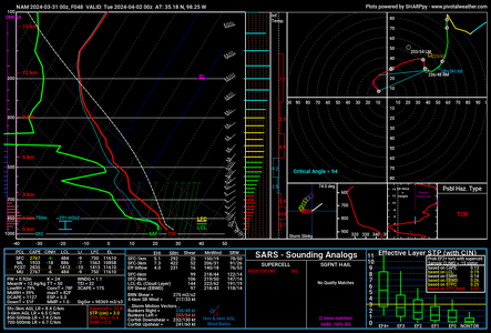
But... when I look at the models for 00Z/Tuesday, I'm seeing the greatest threat in central Oklahoma, with higher low level shear than in eastern Missouri. Cape is also 2,700 in Oklahoma vs 1,700 in Missouri. Storm Relative Helicity is also significantly higher in Oklahoma than Missouri (700+ vs 400+).
Now granted, the 06Z/Tuesday run looks much more favorable for tornadoes in Missouri (which sucks, because that's the middle of the night).
But what I don't understand, and would really like to know is, what about this 00Z/Tuesday sounding in central Oklahoma indicates only hail, and a low tornado risk?

Dan Robinson
EF5
The main 500mb speed max is shown weakening as it approaches the Plains on Monday, with forcing becoming hodgepodge/nebulous as it overspreads the warm sector. I'm assuming that as a result of this, models seem to show numerous subtle impulses with alternating areas of lift that each fire storms/precip early in the day from Oklahoma/Texas through the Ohio Valley. That is in contrast to a nice, clean left exit region with an intact speed max.
I would favor the tail-end cell currently shown by most models somewhere in southern OK/ north TX for the best ambient low-level shear and most-uncontaminated-from-early-precip air mass. There's not a lot to *not* like abount the environment down there, especially the portrayal of the dryline farther west. With the warm front in my backyard, I'll likely be staying up here - but the amount of early-day storms and precip along the boundary here shown all day is concerning.
If the trend of widespread junkvection up here continues, I might consider a trip to SW/southern OK. I like the general configuration/juxtaposition of parameters there, and the latest model runs in more agreement on firing supercells on the dryline.
gdlewen
EF4
I have a hard time seeing through all that--especially the "numerous subtle impulses". A failure to appreciate nuance, perhaps.The main 500mb speed max is shown weakening as it approaches the Plains on Monday, with forcing becoming hodgepodge/nebulous as it overspreads the warm sector. I'm assuming that as a result of this, models seem to show numerous subtle impulses with alternating areas of lift that each fire storms/precip early in the day from Oklahoma/Texas through the Ohio Valley. That is in contrast to a nice, clean left exit region with an intact speed max.
Your remarks about the environment in S-OK/N-TX remind me that the "double-negative is not the same as the affirmative": "Not a lot to *not* like about the environment" falls short of saying, "There's a lot to like about the environment."I would favor the tail-end cell currently shown by most models somewhere in southern OK/ north TX for the best ambient low-level shear and most-uncontaminated-from-early-precip air mass. There's not a lot to *not* like abount the environment down there, especially the portrayal of the dryline farther west. With the warm front in my backyard, I'll likely be staying up here - but the amount of early-day storms and precip along the boundary here shown all day is concerning.
If the trend of widespread junkvection up here continues, I might consider a trip to SW/southern OK. I like the general configuration/juxtaposition of parameters there, and the latest model runs in more agreement on firing supercells on the dryline.
I see those CAM-supercells you mention down there, with their "come hither" looks. But I at this time I can't get past the other model parameters that suggest central-OK will be better. I expect things will sort themselves out over the next 12-18 hours.
Dan Robinson
EF5
Sorry, that's why I don't work for the SPC 
With an intact jet max, there should be a uniform/predictable area of lift arriving in the target area and firing *one* round of storms. What's shown now is the jet max weakening into multiple smaller/chaotic waves that each trigger convection and precipitation, each followed by an area of subsidence - all much harder to predict, harder to nail down timing/location, and more likely to ruin a setup altogether with clouds and early storms. Someone correct me if that's gobbledygook.
The Plains dryline portion of yesterday's event was initially being downplayed by models and the SPC in favor of the warm front, but it doesn't look all that bad now.
Ben Holcomb
EF5
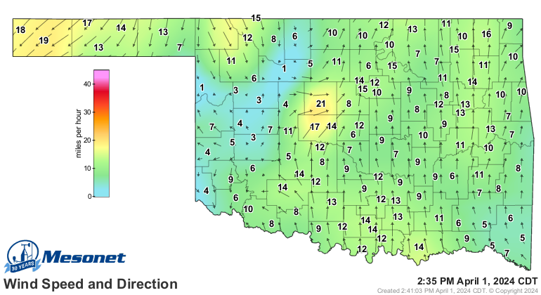
Sure seems like we could have some decent supercells in central/southern Oklahoma. Will be a day to watch the obs. 00Z OUN sounding shows 72/64 and a decent moisture depth of 1km. Pretty good for early April. The air felt muggy today as I packed up camp.
With humid air already here and a jet spreading overhead, any small areas of backed wind will increase chances of discrete supercells. I'll keep my eyes on the mesonet. Forecast Hodos are mostly straight but very elongated. 3km NAM solution really showing an OKC metro kind of day.
I would love to see this trough dig a little bit more and help back our winds. We finally get some moisture and the shear sucks.
I wouldn't drive down if I was Dan, but since I am already here I am planning to keep my eyes on things and head out when/if CI along the dryline seems imminent.
gdlewen
EF4
When I looked at the 500mb forecast winds this morning (3/31) and saw the 70kt isotach break up in the exit region, I kinda glossed over it--really did not know how literally to take the forecast for that particular feature, especially some 36 hours out. (Sounds like it can be taken literally.) Thanks!Sorry, that's why I don't work for the SPC
With an intact jet max, there should be a uniform/predictable area of lift arriving in the target area and firing *one* round of storms. What's shown now is the jet max weakening into multiple smaller/chaotic waves that each trigger convection and precipitation, each followed by an area of subsidence - all much harder to predict, harder to nail down timing/location, and more likely to ruin a setup altogether with clouds and early storms. Someone correct me if that's gobbledygook.
The Plains dryline portion of yesterday's event was initially being downplayed by models and the SPC in favor of the warm front, but it doesn't look all that bad now.
Mark Gressman Jr
Supporter
At the moment, guidance isn't in great agreement with the timing or placement of the best parameters. Looks like there will be a few areas to choose from in an arc from Oklahoma to Illinois, but I'm liking the border of Missouri into Illinois. HRRR has a strong cell there earlier in the day with better backing winds along the warm front, although upper support seems to lose strength early. Prior convection could go either way with possibly providing some boundaries to work with, or throwing a wrench in the works. Either way, there should be a lot of happy chasers if they're lucky enough to get out there today.
Sean Ramsey
EF4
At this point sign me up for Tail End Charlie in s/sw Oklahoma. Dews already in the mid 60's with projected pockets of low 70's this evening. Just from experience this usually means HP bombs although there's enough of a curve in Hodo's that there may be a chance to catch a good photo or two this evening as well as some good sized hail if you don't stay out of the way.
Probably head down toward Lawton with an eye on Wichita Falls and roll eastward from there this afternoon. Although I prefer chasing in northern Oklahoma into SE Kansas I figure it will line out quickly and the southern target give the best chance for them to be discrete. Hopefully there will be enough clearing this afternoon to let things cook sufficiently.
Probably head down toward Lawton with an eye on Wichita Falls and roll eastward from there this afternoon. Although I prefer chasing in northern Oklahoma into SE Kansas I figure it will line out quickly and the southern target give the best chance for them to be discrete. Hopefully there will be enough clearing this afternoon to let things cook sufficiently.
Dan Robinson
EF5
I don’t like the ubiquitous cloud cover and precip at 10am including areas upstream, but that is consistent with what models have been depicting. It appears that few locations will see consequential insolation, so 0-1km CAPE is going to be lacking today. The front has not moved much at all in Missouri and Illinois, and with the upstream precip approaching it doesn’t look like that will change any time soon. There could be some clearing developing in western MO after this initial wave, but it looks like it might be short-lived. I’m not seeing any urgency to get anywhere outside of STL yet.
The Red River still looks like the better target with low-level flow increasing late tonight, but with the action looking like the jungles after dark, I declined to make that 9-hour drive.
The Red River still looks like the better target with low-level flow increasing late tonight, but with the action looking like the jungles after dark, I declined to make that 9-hour drive.
Mike Smith
EF5
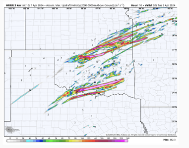
It appears that, during the daylight hours, there are two corridors where there is a high tornado risk. This is the helicity tracks until 9pm CDT. Please note the scale is maxed out.
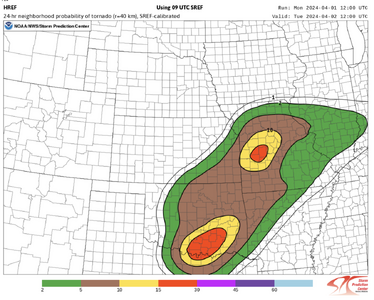
The "two corridors" has been remarkably consistent on the CAMs this morning. It also shows up on the Texas Tech WRF and shows up on SPC's guidance (attached).
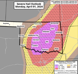
SPC is also calling for 3" hail in the purple area, so chasing may involve getting your pounded.
I often refer back to Bob Miller's tornado forecast checklist and the first (ranked by importance) five on the checklist are all "high" (low/med/high scale).
If one were going to chase today, I would pick southeast Kansas because of the better road network and fewer trees + hills than in northeast Oklahoma. The southern risk area might have a higher tornado risk but I don't like that territory for chasing due to roads + trees + hills.
Addition at 12:40p: I live about 1 mi NW of KAAO. In the last few minutes some rather impressive TCU have developed to the west and radar is showing a small 40+ dbZ cell about 10 mi to the west. This, to me, lends credibility to the generation of the big thunderstorms over north central Oklahoma and the southern Flint Hills counties of Kansas.
Attachments
Brian McKibben
EF3
Explosive development now occurring via mesoscale sat and radar from Enid to Weatherford (and possibly extending further southwest).
Some CAMs did forecast an early round in N Central OK. So we might be right on track.
Some CAMs did forecast an early round in N Central OK. So we might be right on track.
Dan Robinson
EF5
The warm front play in MO/IL appears to be mostly shot now with extensive clouds and precip overtaking it from the south. I won't be heading up there. The only option in the Midwest now appears to be the area in the open warm sector in SE MO/S IL that has remained clear enough to adequately destabilize. Low-level shear is marginal away from the warm front, but CAMs are consistent with a few supercells in this area into the evening. Tornado threat is non-zero but it's looking like mostly a structure/lightning chase up here.
Brian McKibben
EF3
There is a meso-low developing in SW OK. The winds are backing in this region. In addition, the SW is almost to this region. It just passed Big Springs TX area. Storms fired as it came through. I would be keeping an eye on Vis in NW TX and SW OK for th next hour to see if we get initiation.
