2022-05-30 EVENT: ND/MN/IA/NE/KS

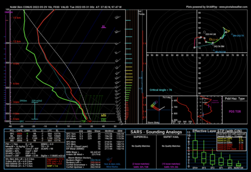
The 18Z HRRR and 3km NAM seem to be increasingly bullish on south central Kansas.

The NAM has a mesolow near Harper KS at mid-afternoon (~ 40 SW of ICT) and the cap goes away about 4pm. The model is very bullish by 7pm as the mesolow causes the ICT sfc winds to back to around 150°. Td is forecast to be 71°.

If you don't want to go to the north central states, this might be a decent alternative.

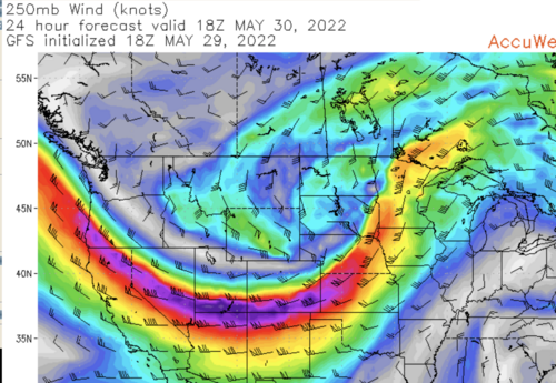
Additional info: 18Z GFS has a 24-hr forecast of 250mb winds of 130kt over KLAA. That is extreme for this time of year. By afternoon and evening, it moves to near HSI with difluence over central Kansas as well as lift from the right-rear quadrant. I have added the 24-hr forecast below.

Safe and happy hunting!
 

Attachments

  • Screen Shot 2022-05-29 at 3.56.51 PM.png
    Screen Shot 2022-05-29 at 3.56.51 PM.png
    859.1 KB · Views: 0
  • Screen Shot 2022-05-29 at 6.48.02 PM.png
    Screen Shot 2022-05-29 at 6.48.02 PM.png
    1.5 MB · Views: 0
Last edited:
Well I can honestly say is this is the most volatile setup I have ever seen up here. Instead of trending down as usual it has ramped up every run of the models. The only thing left to resolve is morning convection and how that affects all this, and whether stuff lines out quickly or not. I have rarely- if ever, seen 300+ j/k of 0-3km cape anywhere near here, which is what models are forecasting.

Targeting Willmar MN and will be planning on staying well north of any storms in order to be able to pick a candidate and try to manoever for a quick look before it races by at 60 knots (!!). Very low expectations, other than the fact that long track, violent tornadoes are a real possibility. The big target up north and west is enticing but with such a risk so close to home the consensus is to stay close.

Good luck to all and drive safely. Extremely difficult day to chase but it's here, so we give it a shot.
 
In order to avoid the potential of sitting in my car all day for nothing again, I'm likely going for the MN target tomorrow. Will make the final call in the morning. With the storm speeds it definitely calls for a different strategy. I'm thinking if there's enough of an arc on the storms, it may be possible to pick an east-west highway, and just try to race east after one cell passes in order to catch the next one. If that's not possible, just gonna have to stay as far in front as I can until one produces, then let it pass.
 
I have concerns with storm mode given nearly meridional flow at 500mb (S to N). I'm sure there will be tornadoes, but storm mode in much of West Central/Northwest Minnesota casts doubt on the 8 hour drive up there.

Another target rises up in Southwest Iowa this evening as well, however this is more contingent on a storm actually going up in that environment. Even if it does and with sig tor values pegging high, I think the tornado potential will be albeit lower than the significant hail/wind threat in this region. Can't rule out a tornado or two before storms die off. This target is about a 4 1/2 hour driive.


The 3rd target for today I see is Southern Kansas just NE of Wichita. Numerous runs of the HRRR have showed a couple supercell thunderstorms firing on the trailing front in this region, winds at the surface do back somewhat down here, and soundings do not look horrible. I'd also think there would be potential for major hail given the high levels of CAPE and good lapse rates. That is my take anyway. If you are dead set on seeing a tornado, no matter how murky or fast moving, I'd head to Western/Northwest Minnesota. If you want pretty storms that might produce nice tornadoes I'd flip between Iowa and Kansas. Slim shot something happens in South Central MN as well on tail end charlie toward 00z as well, but even that is not a slam dunk.

Good day to be chasing if you are a local chaser in any of these areas, bad day if you have to make a travel decision.
 
Wow, tough forecast indeed made murkier by the ongoing surface position of convection and lingering clouds from last night's convection in N NE. I agree with Ethan regarding forecast Skew-T/Log-P Diagrams. Every major model is showing near unidirectional shear above about 700 MB. There is good turning in the lowest 1 km so I have no doubt there will be tornadoes given the ambient 0-3 km MLCAPE, low LCLs, and copious speed sheer profiles as well as directional shear in the lowest 1km, but with the forcing for ascent and near unidirectionality aloft, especially at H5 and H3, I believe the CAMs are on to something with the quasi-linear storm modes and the only thing certain is a higher probability of a wind event. One thing to watch would be any prefrontal surface waves that could kick off isolated, discrete convection that would pose more of a tornadic threat before the main convective line evolves. The storm modes will be a concern too, and less favorable terrain once you get north and east of the I-90 corridor in MN.

Some models are struggling to handle convection further south, with the NSSL/NAM/ARW suite remaining drier but I am seeing consensus on both the 0z/30 ECMWF and the latest runs of the HRRR for convection across far SE NE/W IA/NE KS and also closer to the dryline in S KS. The extent of capping on the furthest southern target remains nebulous, with the ECMWF more favorable for a window of surface-based storms between 0z/30 and 03z/31. While profiles are favorable across both of these areas convective signals seem to gravitate towards cluster-based storms across SE NE/W IA/NE KS relatively quickly with perhaps a more discrete mode on the furthest southern target closer to ICT. Models seem to vary on the extent and strength of CINH this far south, however, so the degree of surface-based convection remains more conditional off of the dryline. If one wanted to believe the HRRR and the ECMWF this would be a high-risk, high reward target with the better chances of discrete storms should all factors coalesce closer to 0z.
 
Three Targets verify in one day. A long time ago in some Plains far far away…

Maybe again today! Agree with the posts above. Kansas does have a meso-low / wave along front. Minnesota is pretty classic east of the low, storm interaction concerns aside.

We will chase Iowa! Waking up in Sioux City after quitting early Sunday. Good rest after NBA playoffs is nice; and, we are in the proper mindset to chase our style. Did somebody say outflow boundary?

Morning rain in western Iowa leaves outflow boundary or two southern Iowa. Should lift north during the day. Intersects DL bulge this afternoon in western Iowa. 5% because we don’t know exactly where yet.

Morning shortwave ejecting early enough to allow recovery. Next wave due late afternoon. Also associated with right rear of 120 kt jet max. Then 500 mb screams at 100 kt. 500/700 mb also has some westerly component for Iowa vs Minn. LLJ is robust in Iowa.

We will just follow our boundary intersection(s) on satellite and surface charts. Good chasing to all. Chase safely.
 
I like the Iowa play. North is just too messy with too many storms and as I'm in Yankton, going to Kansas is too far. We will probably head toward the Minnesota/Iowa border, then follow Matt Hunt's strategy of firing east.
 
I'm also in Sioux City, considering all 3 possible targets. All 3 could produce... or not! Regarding storm motions, I'm seeing 45 knots even in KS, so I'm not sure there's really a great choice anywhere if you're looking for more manageable storm motions. I'm definitely concerned about storm mode on the northern target, but my oh my those parameters are intense. Further south, the cap is of concern. So I'm still not sure what to do! Maybe flip a 3-sided coin and just live with the results. I imagine those hoping to make the TX panhandle tomorrow will choose KS, but I don't think I'm going to make that trip either way, so that's not really a deciding factor for me.
 
On I-90 in far western MN. Agree about the complexity of today's setup. Doubt I go much further north than I-90, will probably play that corridor with an eye south into W Iowa.

If the HRRR verifies... interested in the quasi linear tail-end storm in far Southern MN...
 
I am in Hastings and definitely committed to a KS target. I always have a bias against going so far north, and so far east in the case of MN. Maybe I’m just not as hard core as others, but there are simply limits to how far I am willing to travel, especially if I have to travel back from where I came… Also I have a bias against MN due to roads/terrain (at least in the northern half). Admittedly, I have never been there, but I simply consider certain areas as not part of my hunting grounds… I remember my very first tour with Marty Feeley in 1996, he had parameters, he basically would not go east of I-35, or even north of I-80. Not that he didn’t make exceptions, but I think establishing some guardrails is a healthy thing rather than a desperately obsessive need to see a tornado, no limits…

But I digress, and admittedly look to convince myself I made the right decision… But in this case I do think it was the right call to bail on the north target. Fast storm motion was always a concern, as well as the speed of the synoptic features, storm interference, meridional flow, etc. Reading between the lines of SPC and the affected area AFDs, plenty of potential failure modes, and local AFDs don’t even seem all that hyped up on the tornado threat, considering the background parameters… I have seen this movie before, when the dynamics are simply *too* strong and it’s a complete $hit show… Glad to see some posts alluding to this above, but I wish everyone luck if going for it. Personally have not evaluated the Iowa target so that’s worth a look although out of range for me.

As for KS - I am concerned about models pushing dryline further east than I had hoped - eastern KS terrain is not all that great either. Northeast KS target raises concern of river crossings into even worse terrain of NW MO / SW IA near the river valley… Unsure of northeast KS target or Wichita area target right now, but will drive down to Salina and evaluate then-current obs. Biased toward Wichita to be closer to TX PH for tomorrow. Concerned about winds already veering in the warm sector… And hoping it won’t be another late show like last night, when we finally got the base of the Taylor / Burwell NE storm in view in the waning light at 9:15pm CDT…
 
UPDATE from OMA:

We are going from SUX to OMA for now as a hedge. Still allows back to SUX in time. FSD we remove from consideration north of boundary. So, we could get back to northern Iowa but not SD/Minn.

Our most likely scenario is near KCMO, northwest MO or northeast edge of Kansas. See the meso-low near ICT but we are going closer to the synoptic bulge (though south side of it) KC / northwest Mo.

Hopefully our target picking is as good as Warren Buffet’s stock picking. From Omaha, lol!
 
Waking up at the cabin today in a moderate risk. That wasn’t planned from the chasing perspective. I’ll probably head just a bit west so I am between Willmar and Sauk Center. Hrrr has been very consistent with this corridor. Ive been chasing dor 15 years and I don’t think I’ve never seen some of the parameters being thrown out for this afternoon around here, unless it’s with a nuke proof cap.
 
We are in KCMO and moving west to the eastern Kansas storms. Activity east of Newton and moving toward Butler Co. is most interesting. It is a little more ahead of the immediate boundary. Often that’s good for more sustained moist inflow.

Also watching stuff near Topeka. Northern Missouri seems less likely now. Believe Kansas will be the southern target show. Helping navigate I-435 and options from KCK and OP, so I’ll be off again probably for the day.

We are moving into position to document the Kansas storms. Look for any quick updates on the Discord server.
 
Back
Top