2019-05-17 EVENT: TX/OK/KS/CO/WY/NE/IA

I will be targeting SW Texas. The capping issues are what concern me the most, but the last couple of runs of the NAM seem to be showing the cap eroding over a wider area in the early to mid afternoon and mostly staying that way, especially SW of SJT. We are getting into the outer limits of the RAP's range now too. I won't pretend to know enough to be able to tell you whether it's accurate that far out or not, but the 09z run does seem to be trending similarly to what the 06z NAM was showing. As stated before, the road network isn't great, but the northern targets aren't an option for me logistically, so I'm hoping for the best. Luckily it is looking decent so far.
 
Last edited:
I think the warm front is going to be the best target tomorrow. HRRR really cranks out a few storms in southwest Nebraska and with amply instability and shear, I think it has the best chance to produce. Only thing that would worry me is if storm motions don't cooperate with the orientation of the warm front. However, it looks like storms will be moving NE to NNE and the warm front looks like it will be orientated SW-NE in that area. HRRR still doesn't show much for initiation along the dryline to the south.
 
The HRRR is finally in range, and it isn't looking good for southern plains chasers for Friday. Today's 12z HRRR shows zero convection at 0z 5/18 in any of the states listed in this tread title. It does fire in Nebraska. Another interesting thing is it shows the dryline all the way to the TX panhandle / western OK border by then. If there is a silver lining it is it looks like the cap is just about gone by then in a narrow corridor to the east of the dryline. It's still early - but this is by no means a sure thing in TX.
 
I agree with everything @Dean Baron and @Randy Jennings are saying, and noticed the same thing. RAP and NAM both have some activity on the Eastern TX Panhandle, which is looking like the best option for people not able to make it to NE.

Southwest TX is looking more and more like it's out of the game, unless you plan on doing night time chasing. Both the RAP and NAM show things firing up around midnight Friday night for Southwest TX.

Kansas though... I completely overlooked KS. 3,000 J/kg CAPE, 45kt Shear, strong dryline, and Significant Tornado Convectives on both the RAP and NAM. For everybody who though KS was out of play... it might be worth taking another look.

I think there will be tornadoes tomorrow. As far as where though... I think it comes down to timing with NE and KS looking good during the afternoon and evening, and TX looking good in the evening into the night.

All of that said... I'm 90% sure on heading to Southwest NE (probably North Platte) and making another decision once I get there. I'll look a the HRRR again this evening just to confirm before I head out tomorrow morning.
 
Friday Nebraska is more certain; however, I think northwest of Edwards Plateu of Texas makes a good chase target.

Instability is no issue. It's a little warm at the mid-levels, but above that EML lapse rates are excellent.Turning with height is plenty enough. LLJ is actually pretty backed. Upper jet is slightly more veered than points north, but not as strong.

As for CAMs, the ARW/NSSL version of the WRF does convect by 00Z. Experimental HRRR does too.

Finally, the southern target probably sets up for Saturday, not that it's a great chase day.
 
I'd have to argue differently about Southwest Texas on Friday. Most models convect prior to 00z in that area. The only notable exception is the 12z HRRR, but it's the first run into range and at the 36hr panel, there are hints at convective initiation and a few pixels start showing up in the simulated reflectivity fields. Also note that climo favors convection down there, as we've seen on at least a few occasions thus far this spring.

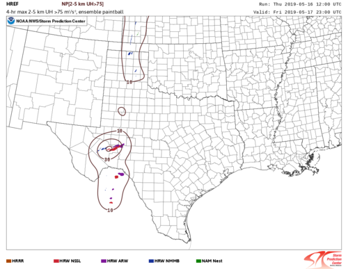
The HREF members largely initiate around 21-22z in Southwest Texas. Here are the UH tracks to give an idea of storm placement and path/length. Notice that by 23z, multiple members show ongoing, robust convection, while the signal to the north is very sparse/questionable. (I removed -12 hour model runs, to keep the data most up-to-date, although the signal has been consistent for multiple model cycles)
uh25_004hmax_pb075.sp.f03500.png
The 12z GFS begins to convect around 21-00z in far southwestern Texas, although the QPF signal is notably stronger after 00z. I'd argue for discrete convection, you'd want a more limited signal, as opposed to storms blobbing up into a cluster or MCS.
 
FWIW the 12z HRRR also blows up a storm in NW Iowa around 22-23z right on the warm front. The warm front itself is oriented more west-east in this area but storm motions look to be more west-east as well so if a storm does go up in NW Iowa, it could have a chance to latch on to the warm front and be a sleeper target tomorrow. Ample instability will be in place and with sruface winds out of the southeast @ 15-20 knots, it should be a good environment if initiation actually occurs.
 
Things can certainly still change with updated model runs throughout the day, but after checking 12Z stuff I am basically calling off W KS as a target and instead am going more for the triple point/WF across far NE CO and into the NE PH. Pretty much all of the CAMs initiate rotating storms in the area, and there seems to be a more favorable SW-NE orientation to the warm front (WF) in that region compared to further east. Moreover, there are indications that the region immediately north of the western part of the WF will remain relatively clear, thus allowing for substantial destabilization. Combine that with a ribbon of moderate moisture content (mid-upper 50s dewpoints across that terrain is very good for May) and easterly winds and it makes sense that storms go up there and survive for a few hours before plunging too far into the cooler air well north of the front. The CAMs are also much less friendly towards developing sustained convection along the dryline, so I'm thinking the cap may largely win out down there.
 
Last few runs of the CAMs have the cold front blasting southeast all the way into central Kansas by 07z. It looks like much of the NE storms that fire either do so just ahead of the front, or behind it. That cold front is going to be the factor of whether not only this day, but the next three days all bust hard.
 
Last edited:
Just took a cursory glance at the OZ runs of the NAM and HRRR valid at 0Z Sat May 18. If I were chasing I would favor the northern target area. I am generally always biased toward a triple point play. HRRR has some really nice UH signals in Nebraska. There is one lone track in southwest TX but quite frankly I can’t understand why. I assume the terrain is assisting with convective initiation because there really is not much convergence along the dryline, with winds more southerly on both models. The cap is also stronger as you go south in TX. Convective initiation will not be a problem near the triple point and under the exit region of the jet. Another thing I don’t like about SW Texas is the lack of a strong LLJ. There are only three potential negatives I see in Nebraska: the 500mb winds are a little more meridional than I would like, which not only affects shear but could also push storms more quickly north of the front; storm mode could be an issue if cells are numerous and interfere with each other; and, having not refined a particular target, the sparse road network if the Panhandle ends up being the target area (or cells moving from NE Colorado into the NEB panhandle. If someone were logistically limited to TX it’s certainly worth taking a shot along the dryline, if something goes it could be a beautiful isolated supercell but with a limited LLJ and high temp-dew point spreads I wouldn’t expect a tornado.
 
Looking at the latest runs of the CAMs, they all initiate something in far NW Kansas or near the KS/NE state line, then move it northeast into NE. Specific locations and details vary, but they all seem to be picking up on that general idea. By around sunset it looks like the storms could cross north of the front (and thereby become elevated), but there seems to be pretty good agreement on the general idea of storms initiating in northwest KS or near the state line moving up into NE during the time period between about 21Z and 3Z. Given the environment, the storms are very likely to be supercells with potential for tornadoes and very large hail. I have prepositioned in Lamar, CO for tomorrow's chase, and unless things look a lot different in the morning, will probably head to northwest KS and expect to track the storms into NE.
 
The synoptic front has more of a cold frontal push look to it in NEB northeast of the triple point. Looks like you would have to go to northeast NEB / southeastern SD for a warm front segment with backed winds. However, the HRRR shows no convection in that region as it is likely too far removed from the stronger forcing, especially given the axis of the stronger cap - 11-12 degrees C - is nosing up that way at 0Z. Road flooding is an issue up that way anyway.

There are some hellacious UH's along the front near and east of the triple point per 10Z HRRR. Agree with @John Farley that if looking for a more isolated / discrete supercell that is not in danger of crossing north of the front it might be best to head south toward the NEB/KS border, just east or southeast of the surface low. If I were out there today, I would probably initially stage in North Platte and from there decide whether to adjust within that general area to play the triple point or drop south toward McCook for the more southern play.

HRRR continues to show a lone cell down in southwest TX yet the parameter space per NAM and RAP just does not look anywhere near as appealing down there. I assume that CI is terrain-induced but with a weaker LLJ that doesn't strengthen until after 0Z and high temp-dewpoint spreads I wouldn't expect a tornado down there, but what do I know...

EDIT: originally had a typo mentioning southeast TX but meant southwest TX. And sure enough I know nothing because as I edit this at 6:10pm CDT there was already an isolated supercell down there with a confirmed tornado.
 
Last edited:
Just a quick note. Like most people, I’ll be heading toward the Western Kansas/Nebraska border today. If I had any confidence something would pop further down the dryline in KS I would wait there instead. That could still change for me. Good luck to everyone out today and drive safe!
 
Woke up to see my target was more or less centered in the region killed off by the 6Z SPC outlook...I could only smile. h5 VVs have been dead the entire length of the build up to this system within the past several days, and when you add in a rare HRRR storm boycott, it doesn't bode well for those of us who chose the southern target (in any part of it). As previously mentioned, even if that TEC happens in deep SW Texas, the shear environment (IMO) just doesn't look conducive to tornadoes....but then again there's ALWAYS a tornado-warned sup in that area while other storms struggle north of it.It Looks like it would be a long, all-day wait, then turkey towers, then maybe some echoes, followed by a struggling updraft that dies with the setting sun. I've seen that way more times than I've seen a tornado in this situation. Still time to re-consider but the window is closing. Current data isn't changing my mind,
 
Woke up to see my target was more or less centered in the region killed off by the 6Z SPC outlook...I could only smile. h5 VVs have been dead the entire length of the build up to this system within the past several days, and when you add in a rare HRRR storm boycott, it doesn't bode well for those of us who chose the southern target (in any part of it). As previously mentioned, even if that TEC happens in deep SW Texas, the shear environment (IMO) just doesn't look conducive to tornadoes....but then again there's ALWAYS a tornado-warned sup in that area while other storms struggle north of it.It Looks like it would be a long, all-day wait, then turkey towers, then maybe some echoes, followed by a struggling updraft that dies with the setting sun. I've seen that way more times than I've seen a tornado in this situation. Still time to re-consider but the window is closing. Current data isn't changing my mind,
This is exactly where I'm at too. With each model run, I get more doubtful. With the exception of the SPC mesoanalysis showing the cap eroding within the next few hours, the only saving grace is that because I live in San Angelo, maybe I'll get lucky and something will pop within driving distance without having to commit an entire day to sitting in rural west TX with my fingers crossed. Good luck and safe travels to everyone out there today. That northern target is looking pretty good
 
Back
Top