2019-05-17 EVENT: TX/OK/KS/CO/WY/NE/IA

Not to derail this topic, but a lot of people still seem to be using the NAM leading up to chase time. I can see using the 3km NAM, but when it diverges significantly from the HRRR, it's usually wrong.. Even the day before an event, for some reason, I see a lot of chasers even citing the 12km NAM...

I don't find much utility in using the 12km for convection at all. The higher resolution 3km NAM is helpful 1-2 days out, but for the general picture. It has issues with dew-points, to just name one bias. Either way, I may still weigh at least a small amount of confidence to what the 3km NAM/NSSL WRF/HREF show the morning of a chase. For me, with convection allowing models during the day of a chase, I use a much heavier emphasis on the HRRR, let's say, maybe 80/20 between it and other models. Of course, observations with your own two eyes, as well as mesoanalysis, surface observations and radar/satellite data are of the most help once you're approaching convective initiation.
Depends on what you're going for. Tough to use the HRRR for assessing near-term environmental trends.. too much noise in mass fields thanks to resolving convective processes, hence why SPC prefers the coarser RAP for mesoanalysis. If we're talking convective trends and placement, then yeah using NAM is grounds for being burned.. The parameterization scheme, unless recently changed, is a tropical one that doesn't work well at all in low-forcing EML environments. Mass fields can still get you where you need to be, though.
 
Depends on what you're going for. Tough to use the HRRR for assessing near-term environmental trends.. too much noise in mass fields thanks to resolving convective processes, hence why SPC prefers the coarser RAP for mesoanalysis. If we're talking convective trends and placement, then yeah using NAM is grounds for being burned.. The parameterization scheme, unless recently changed, is a tropical one that doesn't work well at all in low-forcing EML environments. Mass fields can still get you where you need to be, though.
I rarely use the HRRR once the morning is over during a chase. It has issues resolving ongoing or recently initiated convection, although they've tinkered to make the short-term simulated radar fields more realistic. Still, we've had plenty of cases this season already where the 2-hour HRRR forecast was way off from reality.

Models are useful tools leading up to an event, but once it's close to game time, not so much.
 
I use the GFS and European about 4-5 days out to plan when I am going to chase. This gives me time to start preparing by requesting vacation time, schmoozing the wife, and getting the car ready.

I use the NAM the day or 2 before I leave to pick a target area (in conjunction with air maps and soundings). The morning of, I look at the HRRR and radar to help me hone my target. I usually have to drive another few hours to get a better spot the morning of a chase.

That said, the HRRR has been dead accurate and equally dead wrong. I remember using the HRRR one day last year for a Colorado chase and got to an intersection in the middle of nowhere (Punkin Center) where the HRRR had forecast a supercell. Tons of chasers parked along the street just waiting. The skies were blue and not a cloud in the sky. Meanwhile, radar showed a small thunderstorm just starting to form two hours away and tracking to the southeast of where everybody was staged. I went after it, and watched it grow into one of only two tornado warned storms that day. NWS actually tornado warned it based upon my report (I was the only one chasing the storm). Meanwhile, I was watching spotternetwork dots 80 miles away moving from Punkin Center towards the storm. The storm went all the way into Kansas before they caught up to it.

Lesson: Use the HRRR to help you pick a target area the morning of, but then switch to radar and eye observations during the chase. There's a reason they call the HRRR a forecast and not a prophecy.
 
Back on track with Friday...

There are some concerns about convective initiation down the dryline. Looking at the GFS trends, the warm sector has been slowly shrinking, in addition to a narrowing of the favorable instability axis ahead of the dryline.
It's still early to be throwing out specific targets, but I think the highest confidence right now at convective initiation is in Nebraska. The issue is that it could get messy here. CI is more uncertain to the south, but that would allow for a more discrete storm mode. Another target could be southwest Texas... That familiar high risk, high reward with a lone supercell going to town around I-10.

I played with the latest 21z run of the SREF to look at 00z Saturday/Friday evening. The SREF severe probabilities are similar in an elongated corridor without a clear favored "target." The image below would suggest the best lift is up around the central Plains, along with the hint at more lift down near I-10. Here are the wind crossovers and mean lifted index:
sref_overlay.gif
 
Not to derail this topic, but a lot of people still seem to be using the NAM leading up to chase time. I can see using the 3km NAM, but when it diverges significantly from the HRRR, it's usually wrong.. Even the day before an event, for some reason, I see a lot of chasers even citing the 12km NAM...

I don't find much utility in using the 12km for convection at all. The higher resolution 3km NAM is helpful 1-2 days out, but for the general picture. It has issues with dew-points, to just name one bias. Either way, I may still weigh at least a small amount of confidence to what the 3km NAM/NSSL WRF/HREF show the morning of a chase. For me, with convection allowing models during the day of a chase, I use a much heavier emphasis on the HRRR, let's say, maybe 80/20 between it and other models. Of course, observations with your own two eyes, as well as mesoanalysis, surface observations and radar/satellite data are of the most help once you're approaching convective initiation.

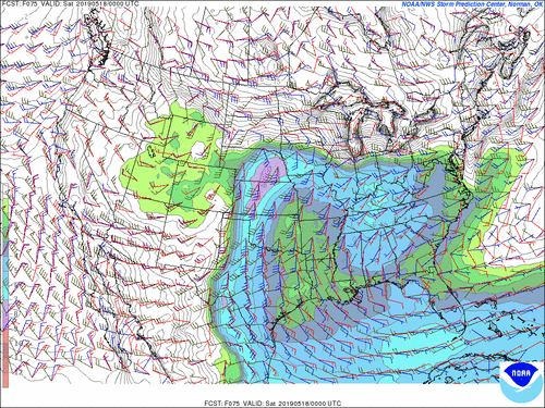
The 12-km "mesoscale" NAM has pretty much run its course at this point. The GFS has caught up to it in terms of grid spacing, and the two run just as frequently. So unless you have a need for faster forecast latency or you prefer the NAM's physics, there just isn't much point to it anymore.
 
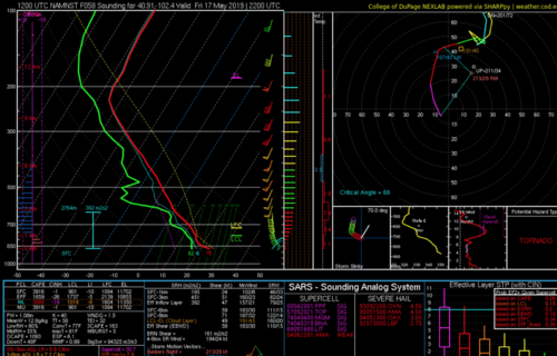
Back to this situation, I am heavily inclined to play NE Colorado into far NW Kansas and SE Nebraska Friday. Less hordes and up there CI should not be an issue. This is the 3KM NAM sounding from near the CO/NE border...Screen Shot 2019-05-15 at 11.09.29 AM.png
 
The 12-km "mesoscale" NAM has pretty much run its course at this point. The GFS has caught up to it in terms of grid spacing, and the two run just as frequently. So unless you have a need for faster forecast latency or you prefer the NAM's physics, there just isn't much point to it anymore.
I pretty much ignore the 12km NAM now. It sucks at hours 60-84 anyway, so why bother? Resolution on the GFS is just as good as you said. I just wait for the hires NAM to be in range, which IMO is 48hrs or less.

Regarding what to use to chase? Models are helpful yes, but day of, I start off looking at mesonet here in OK and the SPC Mesoanalysis page. I then typically compare that to hi-res NAM, HRRR, RAP forecasts and look for differences that may be problematic or result in model outputs not being accurate.

HRRR is pretty impressive in its ability to resolve thunderstorms you absolutely can't chase by it a few hours out or you run a high risk of getting burned. I tend to find an area where I believe CI will occur and make sure that I have good directional roads N/S/E/W so that when convection does occur I can move towards it if I like what I'm seeing on Mesonet and Mesoanalysis from SPC.

As for Friday specifically, my biggest concern for tors are the possibility of high LCLs, capping and less than optimal shear environment. Plenty of time for these to be resolved, at least partially. I do think there will be a few supercells, and probably a couple tors south, they'll also probably be very photogenic. They'll also be close to dusk/dark which will create some problems.

The northern target area looks a bit better at this point for tor density IMO. If I could go either direction Friday and I absolutely wanted to try to get a tor, vs risking dusk structure shots, I'd head north.

You can start taking the NAM more seriously with the 18Z run today, see how that compares with GFS, GFS FV3 and Euro.

My 2 cents.
 
Last edited:
Back on track with Friday...

It's still early to be throwing out specific targets, but I think the highest confidence right now at convective initiation is in Nebraska. The issue is that it could get messy here. CI is more uncertain to the south, but that would allow for a more discrete storm mode. Another target could be southwest Texas... That familiar high risk, high reward with a lone supercell going to town around I-10.

It's not too early to be throwing out targets. Many people are driving starting tomorrow, and we need to figure out where to go. Right now, I see three possible targets: Southwest NE to the middle of NE, Northeast TX Panhandle, Southwest TX.

I'm not a meteorologist, so I can't provide expert analysis, but here's what I'm thinking:

Southwest NE to the middle of NE:
This seems to have almost everything going for it right now including decent instability (~3,000 J/kg) and strong shear (65 kts). My only concern with this location is that the moisture seems to be a little too far to the north. RH is around 50% Friday, although as I'm sitting here typing, new runs are posting and that is increasing. Flooded roads are a concern, but my analysis is that the storms will fire more to the southwest and middle of the state, and won't reach northeast NE until later in the evening or overnight. Nighttime chasing will be very dangerous in this area when you combine the already inherit dangers of nighttime chasing with the flooded and closed road network.

Northeast TX Panhandle:
This area also has decent instability (~3,000 J/kg) and shear (50 kts), although not as great as NE. Moisture looks better though, as the dryline appears stronger here, which may help. Timing appears to be more favorable later in the evening though, which may result in some nighttime chasing. Road network and visibility is better than NE though, especially given the recent flooding.

Southwest TX (and into Mexico actually):
The strong dryline extends into southwest TX. Instability is strong with CAPE up to 4,500 J/kg. Shear is also good at around 55 kts. I think this setup is better than the northeast TX Panhandle play. This might be one of the best plays as it's being overlooked, and most chasers will choose NE or the TX Panhandle.

Again, I'm no expert so feel free to correct and add to anything I've mentioned. You won't hurt my feelings.
 
Staff note
Given we are looking at the arrival of a potentally extended period of chasing featuring higher-end setups, it makes sense that the TA has suddenly become very busy. There has been some slightly off-topic discussion in this thread (that I myself participated in), but those who went off on that tangent have done a great job of relating it to the event at hand. For that, the staff is very thankful and we welcome continued posting of a similar nature.

Thanks, everyone, for participating so far!
 
Increasingly interested in a Nebraska target. Looking around at overall synoptic evolution and forecast soundings.. My original target of W KS is becoming less and less promising, with increasing 700 mb temps throughout the afternoon and evening. This is less of a problem farther S into TX PH.

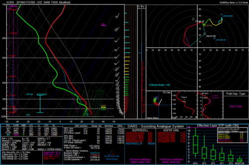
Nebraska, roads and convective mode questions aside, looks ready to go, however. Modified 23z sounding (00z is contaminated by QPF) is... pretty good, to say the least. NEB.png

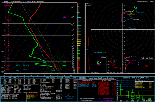
For comparison, a modified DDC sounding is good, but the capping raises concerns for a blue sky bust.

DDC_mod.png


This is alleviated a bit farther S into the panhandles.

I'm not sure where I want to go at this point. The north target, as usual, has more storm mode issues, but with Nebraska there's also the dreaded roads issue. Farther south, a cap bust is absolutely possible, but it's tough to say at this point which is better. I have time to decide but it's tough right now to decide either direction.
 
Increasingly interested in a Nebraska target. Looking around at overall synoptic evolution and forecast soundings.. My original target of W KS is becoming less and less promising, with increasing 700 mb temps throughout the afternoon and evening. This is less of a problem farther S into TX PH.

I agree that NE is starting to look more promising over my initial W KS target (although there is still time to decide between the two). My primary concern with NE is that even RM storm motions still have a large northerly component, which means updrafts are going to tend to get pushed across the WF and into stable air (and the WF itself does not look to make much Nly progress during the day). The region of favorable low level shear is pretty narrow in NE, so a storm is going to have to more-or-less latch onto the WF in order to give anything more than a flash-in-the-pan show. Perhaps we will get lucky with moisture pooling closer to the triple point and sagging south along parts of the dryline.

Granted, if moisture verifies better than forecast, then it will also be possible to play both targets by starting north first then dropping south towards the evening.
 
I say all that and then just saw the 18Z 3 km NAM. Boy that is an unnattractive looking reflectivity field (storm mode wise). It also seems like the WF is forecast to have a more WSW-ENE orientation than I had been seeing previously, however. In fact, the 18Z 3 km NAM spits out a couple of coherent UH tracks in NE CO including a whopper of a long-tracker that seems to ride pretty close to the WF from Brush up through Sidney, which could prove to be pretty easy to chase and entertaining to boot!
 
My concerns over the low warm front residency time and subpar road options are probably going to keep me in West Kansas chancing a cap bust over Nebraska at this point. Being an Illinois chaser, I love a good warm front chase but that warm front setup in Nebraska is generally not what I look for if I want a good warm front rider personally.
 
I still see mixed signals for Friday, at least along the dryline target from, let's say, southwestern Kansas to the Texas panhandle/Northwest Texas.

Confidence remains relatively high across the Nebraska vicinity, but caveats include storm mode and tendency for storms to, potentially, cross over the warm front into a more stable near-surface layer. I'm relatively confident that something is going to go up in Southwest Texas as well, but chase terrain/road networks start getting kinda iffy down by I-20 and especially around I-10. Still, any semi-discrete storm that goes up in that environment will most likely become severe, rapidly.

The global, high resolution and convection allowing models are all over the place for dryline convective initiation (CI) in that middle area. The 3km NAM has, for three runs so far, shown virtually no CI in that area. On the other hand, the GFS and RGEM have signals of discrete/semi-discrete convection in or near the eastern Texas panhandle. The NSSL WRF seems to split the difference, although it initially convects up and down the dryline from the Texas South Plains right up into Kansas. Upon closer examination, it initiates from the panhandles into western Kansas, but struggles to sustain this convection. Meanwhile, to the south, it blows up an MCS-like feature down into Northwest Texas.
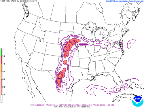
SREF_prob_combined_0.01_30_2000__f051.gif
The SREF mean highlights the two higher confidence targets well, if you look at probabilities for >2000 J/kg MUCAPE, 0-6km shear >30 knots and 3hr convective precipitation at 00z Saturday. Even though there's a relatively minimum in the middle, you could argue that you'd rather have sparse/little convection along the dryline. Given large scale forcing, which is more than adequate, should any surface-based convection initiate along the dryline around the 22-00z time frame, it's hard to see why it wouldn't become severe.
 
Back
Top