2019-05-17 EVENT: TX/OK/KS/CO/WY/NE/IA

Joined
Apr 5, 2015
Messages
87
Location
Norman, OK
While we sit here at six days out, it appears that a significant severe weather event will be possible across portions of the central and southern Plains on Friday. Latest trends in ECMWF deterministic and ensemble guidance is for a deep wave to take hold in the west. As heights fall across the Rockies, favorable mass response will induce strong SSE trajectories across most of the S Plains. The result will be a likely corridor of low 70s F dewpoints across W Texas with 67-69 F dewpoints across much of the panhandle and western Kansas area. Lift accompanying the wave will be aided by a sharpening dry line beneath southwesterly flow aloft.
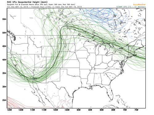
EC_Spread.png
Shear profiles will easily favor discrete supercells with a large-very large hail threat. Tornadoes will be possible as well although details are going to vary being six days out. Pattern recognition and trends in ECMWF/EC ensemble lead me to believe that Friday has a pretty high ceiling with a significant severe weather episode possible with favorable timing. GFS is not as deep with the wave nor does it have the same timing, but this is just about the Euro's sweet spot and I expect the GFS to come in line with the ECMWF by mid-week. This is a classic May dry line tornado setup. Should be a really good time out (minus the herds) if trends continue.

There will likely be a secondary northern target along a synoptic warm front in the Dakotas and adjacent area. While shear profiles will probably be enticing here, very strong warm air advection and synoptic lift will probably result in rapid upscale growth, and models show a clear signal for an MCS to develop and track along the baroclinic zone.

Targets to be refined throughout the week.
 
This will be an interesting forecast for me. The target everyone has been watching is down along the dryline in KS and OK. The GFS really wants to ramp up the northern target too along the warm front in SD and possibly MN. At this point I am not sure if there is really a wrong choice to make between the two. Forecast soundings in both areas show some weakness if H5-H3 winds. For now I would be leaning towards the northern target for two main reasons with it being closer to home for me and also it looks like LCL's might be better along the warm front. A long ways out so it'll be interesting to see how the details evolve. Unless the set up goes to complete crap, I will likely be out somewhere on Friday.
 
That is quite a difference between the Euro and GFS as highlighted by Brandon. The operational Euro is fairly similar to the ensemble mean Brandon posted. Whereas the Euro has the 565 DAM line digging down to the Mexico border, the GFS has it down only to the latitude of southern NV / northern AZ/NM. The GFS also may be faster, as it lifts the mid-level low to WY by OZ Sat while the Euro has it at the intersection of the NV, UT and ID borders at that time. If the Euro is indeed to be favored, I would have to discount the surface features I am seeing on the GFS, which shows the synoptic front in SD as more of a cold front. Still, the important features are there, notably a sharp dryline from southwestern KS into the eastern TX Panhandle. Exact longitudinal placement will of course change between now and then anyway, and a deeper trough should only enhance the backing of surface winds east of the dryline. What’s interesting is that despite the 500mb differences, surface low placement is similar on both models and in fact the GFS surface low is actually deeper - maybe because it is closer to the mid level low on the GFS? I don’t know, I can make the observation but will leave the interpretations/explanations to the smarter people on here, that’s beyond my pay grade. CAPE is extreme on the GFS. I don’t have access to any of the pay model sites to compare any other surface features or severe parameters on the Euro with any degree of detailed resolution.
 
While we sit here at six days out, it appears that a significant severe weather event will be possible across portions of the central and southern Plains on Friday. Latest trends in ECMWF deterministic and ensemble guidance is for a deep wave to take hold in the west. As heights fall across the Rockies, favorable mass response will induce strong SSE trajectories across most of the S Plains. The result will be a likely corridor of low 70s F dewpoints across W Texas with 67-69 F dewpoints across much of the panhandle and western Kansas area. Lift accompanying the wave will be aided by a sharpening dry line beneath southwesterly flow aloft.

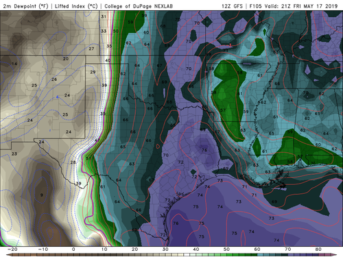
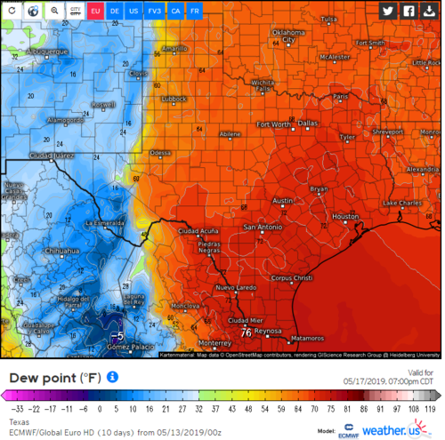
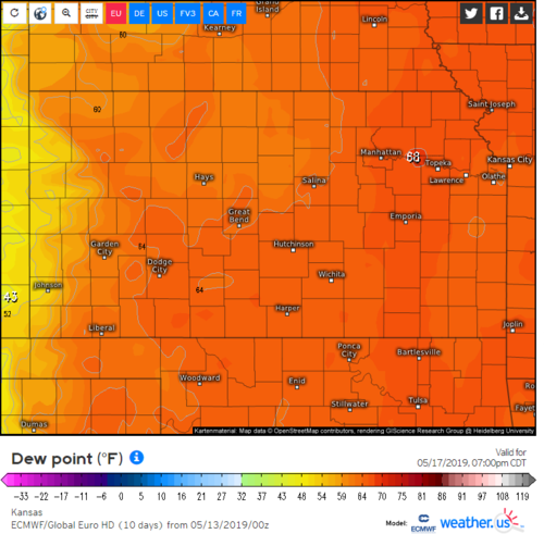
With all due respect, where are you seeing 70 F dews anywhere relevant to this setup? I don't see the 70-F isodrosotherm west of I-35 in either the GFS or ECMWF control member:
GFSSGP_sfc_dewp_105.png
Weather us (1).png
Weather us.png

This definitely looks like one of the first solid Plains dryline setups this year. What concerns me is how shear is impacted by the timing of the wave. As of the 12Z GFS this morning, the wave is a little further west than I would like to see it for optimal shear over the Plains. The GFS also has a tendency to slow things down at this range, so the placement could get worse as time goes on. Also, due to a pretty gnarly LLJ there isn't a ton of speed shear above the PBL. Lastly, 700 mb temps are a little on the warm side, so CI is not of high certainty at this point given the forecast Tds I'm seeing of the low-mid 60s immediately ahead of the dryline. However, if something goes, there is a high probability of it being supercellular, although bases could end up being a bit high.

I know everyone is excited after a really crappy 2018 and a slow start to 2019, and those of you who know me on this forum know of my conservative bias, but I would caution about speaking about this setup being epic and paying everyone off. It certainly does not appear to be a slam dunk at this point. The good news is we have several days to watch this come in and things could definitely change for the better.
 
Jeff, you quoted a statement I made looking at 5/12 00z ECMWF/GFS data, whereas you're looking at today's 12z GFS. Nonetheless, I still anticipate mid-upper 60s F dewpoints across W KS by 00z Saturday.
 
I'm noticing a lack of precipitation on some of the forecast models for Friday (NAM/GFS). FV3 develops a cluster of convection along the warm front near the NE/SD border, however it seems as though there may be some capping issues? I'm not sure what to take away from this lack of convective activity when we have 45 knot shortwave pushing through around 21-00z. Some of the best soundings I could find on the 12z NAM was across Northeast NE/SD, however CIN was in excess of -100 which isn't favorable at all. Not sure what to make of the lack of convection on the models.
 
I'm noticing a lack of precipitation on some of the forecast models for Friday (NAM/GFS). FV3 develops a cluster of convection along the warm front near the NE/SD border, however it seems as though there may be some capping issues? I'm not sure what to take away from this lack of convective activity when we have 45 knot shortwave pushing through around 21-00z. Some of the best soundings I could find on the 12z NAM was across Northeast NE/SD, however CIN was in excess of -100 which isn't favorable at all. Not sure what to make of the lack of convection on the models.
Ethan, that's a noteworthy concern in most situation. I would urge you to keep in mind this is the edge of NAM capability and it's not particularly good at the end of it's ability. If the same thing is showing up at 48 hours or 36hours out, other models showing similar capping that could be a problem. At this point, I think you hit on an important piece which is the possible breaking of the cap between 21Z and 00Z due to other factors then just the cap. Shortwave timing will matter but right now the broader environment looks solid. If the cap is still ultra strong and maybe we get less or no energy ejecting, then that's a problem, at this point I'm not worried about it (could change my mind though).
 
I fully expect a secondary target farther south. FV3/GFS op do convect toward 01-02Z which is still daylight. However we don't need it to tell us. Trey is also right regarding the NAM past 36 hours.

PVA is coming in; warm 700 mb is cooling with time; LLJ cranks up; surface winds are backed. ECMWF convects south. There's a model I actually care about. At the surface a slight DL bulge is forecast out of the Panhandles. ECWMF hints too with isobars. While I'd prefer a true outflow boundary, the southern stream jetlet should promote a slight DL bulge.

None of this guarantees anything. NAM hints at stubborn cloud cover east of the DL. However pattern recognition supports two targets Friday. Euro erodes those mid-level clouds which is believable in May. Even then it could be mainly hailers. If dews top 65 it'd get interesting.
 
The aspect that has made me the most nervous is the LCLs in the forecast soundings from the GFS. Even today's 12z GFS have really high LCLs (generally abover 1400-1500m) along the DL in Kansas and this has been pretty consistent on the GFS. Once you get a little east of the dryline, the LCLs start to drop but so does the shear. Seems the overlap isn't there right now. Today's 12z NAM has better LCLs, but it's hard to tell how seriously to take it since the setup just came into range for the NAM.

If the GFS verifies with those LCLs, we are probably looking at high based supercells with little chance of a tornado, especially since shear isn't over the top.
 
PVA is coming in; warm 700 mb is cooling with time; LLJ cranks up; surface winds are backed.

There is not any appreciable cooling at 700 mb over KS during the day; I see MAYBE 1 C, but most areas see 0 C of 12-hour temp change.
PVA does not imply UVV (DVPA does).
Surface winds not forecast to back until 00Z.

Let's illustrate:
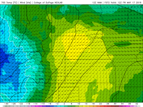
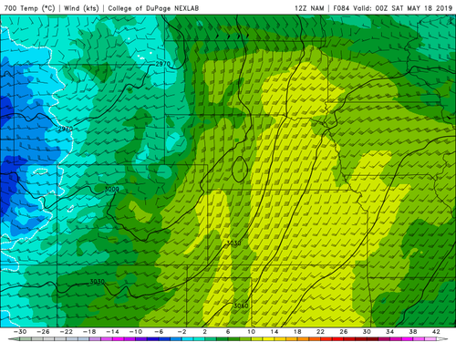
700 mb temperature
  • 1200 UTC
h7_t_f72.png
  • 0000 UTC
NAMCGP_700_temp_084.png

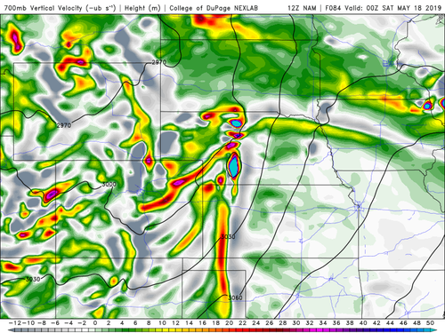
Yes, some of the colors in W KS change, but that's not due to synoptic scale forces. It is due to the dryline circulation, which the large-scale models struggle to resolve, but mesoscale models (like the NAM) can at least partially resolve:
NAMCGP_700_vvel_084.png

Note the corridor of moderate-strong upward velocities at 700 mb coincident with the area of apparent cooling. That band of velocity represents parcels being lifted adiabatically (which causes cooling by the time they get up to 700 mb since the environmental lapse rates are less than dry adiabatic), but does not represent differential temperature advection associated with the larger-scale trough. Note also that band of upward motion is much weaker at 21Z and is non-existent before that. Cooling does finally set in after 00Z, however, but it would be nicer if the cooling started earlier in the day.

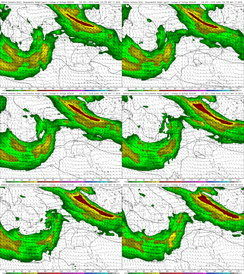
Speaking of the trough...
12Z-20190514_GFSUS_500_spd-72-90-25-100.gif

It looks to me like the mid-level jet core weakens throughout the day, only starting to "resurge" around 06Z. That suggests to me the dynamical support fades during the day, and it appears the wave itself fills just a tad (watch the 5580 and 5640 m contours across the W US).

This to me perfectly explains why the models are hesitant to spit out precip across the dryline. The shear and instability will be there, but the triggering ingredient may end up not being there sufficiently due to lack of help from larger-scale forces. Since it remains rather warm aloft, capping will prevent CI for quite some time. Before 00Z it looks like there is very little forcing for convection outside of the dryline circulation itself along the dryline. Continued southerly flow should continue to bring in moisture throughout the day, however, which may end up being the saving grace here, as it will limit stabilization as heating goes away towards sunset.

I do think storms will form, but I suspect they will be quite isolated (which should also make them more picturesque should they go supercellular). But certainty is lacking at this point.
 
Will likely chase south as far as possible to avoid the 1-40 Armageddon to come. Even in Arizona, I can hear the nervous buzz of engines getting ready. CovT is 87 f near Childress, which is close to the forecast high. Hope the DL moves back west just a little. LCL's are an issue ATM.
 
NAM hardly ever resolves QPF on a dry line thanks to its convective parameterization scheme. Limited forcing will keep coverage low, but there will be storms. In the end everyone is gonna HRRR chase this one.
 
NAM hardly ever resolves QPF on a dry line thanks to its convective parameterization scheme. Limited forcing will keep coverage low, but there will be storms. In the end everyone is gonna HRRR chase this one.

Is that not true with every chase anymore? It's the most rapidly updating operational model that exists and it contains individual thunderstorms. I'd argue that statement is a tautology.
 
Back
Top