2017-03-26 EVENT: KS/OK/TX

Joined
May 6, 2005
Messages
288
Location
Moore, OK
Not sure if moisture will make it to KS but figured, I would include them just in case.

GFS and ECMWF have been consistent for several runs now showing a trough moving across the region on Sunday. One of the big limiting issues will be moisture.

Surface
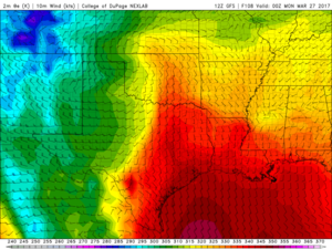
Cyclogenesis begins overnight Saturday in SE Colorado and strengthens on Sunday as low moves into TX/OK panhandles. This allows winds to back to SSE east of the DL in the warm sector in OK and N TX. The warm front sets up in southern KS. Daytime highs look to be in the mid to upper 70s.

Friday's system pushes the 60° isodrosotherm all the way to the gulf coast where it stays until 06z sunday. Then rapid moisture advection brings mid 60 Tds to DFW and low 60s to KS/OK border by 00z Monday. It will be key to watch how far south the moisture goes with Friday's system.

The theta e tongue sets up along and east of I-35 from DFW to Wichita.
00ac26df2016b06b5bb1552e0838f5ee.png

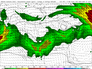
Upper Level:

Negatively titled 500 hPa trough moves across the region Sunday afternoon and evening. Looking at 50-60 knots from the SW.
11804b85f22bffeec74a0dcddede9944.png

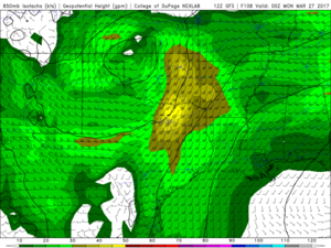
At 850 hPa, the warm sector is overspread with 40-50 kts from about 190°. Needless to say low level shear should be more than adequate for tornadoes. 0-1km helicity greater than 300 m2/s2 look likely. And at this time I don't see any problems with VBV wind profiles.
ec155b777dfd8d4eaae475ecf87a29ca.png

Conclusion:

Potential is there for some decent severe weather including tornadoes. The 500 hPa trough comes in right behind the friday trough so we have a short wavelength. This will potentially limit the available moisture. But with that said the friday system doesn't clear the Gulf and leaves the moisture on the coast. So confidence is medium that moisture will at least make it to north TX. Depending on surface temps and forcing I wonder if we will have any capping issues. Too far out to tell, but I will be keeping an eye on the models and the 12z NAM on Thur.

Special Treat:

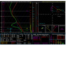
Sounding for north Dallas
b348e822b6d9066e218e33aa117c217c.png
 
The GEFS has remained rather uncertain as to the shape of the jet associated with this trough. As a result, there remains considerable uncertainty as to whether a widespread severe threat will materialze, and if so, where. Also of concern is moisture quality. GFS forecasts have been fairly consistent as of late of getting some 60+ dews into Oklahoma, but it's "just in time" kind of moisture.

Personally I'm not too encouraged by what I'm seeing, as the event has also trended further east, mostly east of I-35. So an uncertain moisture scenario and uncertain shear in a less-than-favorable chase terrain doesn't get me too excited. But we will see what happens.
 
The big issues to my mind are: wave timing and moisture return.

The GFS moves the 500 mb wave into the Plains a little too early, which could result in too many storms. It also screws up the hodographs by creating a veer-back-veer profile (though the jury is still out as to whether VBV is actually "bad"). Additionally, the moisture is a question mark. As Jeff mentioned, it gets there "just in time" in the GFS. Even with limited moisture, however, I think we could see a few tornadoes: low-level shear is spectacular almost everywhere in the risk area. And, if we can realize mid-60's Tds (as the GFS forecasts), strong tornadoes would be possible.
 
With what Jeff and Gabe has already noted about the "Just in time" moisture issues and the timing of the 500mb wave is a huge question with this system. It is also interesting to note that the EURO model has a slightly slower solution and ever so slightly to the west of what the GFS operational shows. One of those classic "Could go big" or "Bust" written all over it. Also wanted to note that the capping could be an issue as well with GFS showing the CIN filling back in at 00z and if you look back to 21z, it has a wide open hole just east of the dryline.

I think that if we can get the 500mb wave (Which GFS usually tends to be too progressive) and the deep moisture to return all the way north into Central Oklahoma. This could yield to a very big day from OUN down to DFW along and just west of I-35. Definitely worth getting a little tingly inside! I've heard Turner Fallis nice this time of year, and may take a look see down there on Sunday.
 
This event has been kind of reminding me of 2010-05-10 except on a much lesser magnitude than the parameters were with that event (I think someone else may have mentioned this somewhere else), with the nature of this compact wave. As of right now, quality of moisture return is the biggest question in my mind. If we can get the moisture, then definitely could see a setup where a few tornadoes are possible. Not to sing to the choir or report what anyone else has already said. It will be interesting to keep an eye on.
 
My biggest concern at this point is definitely with the moisture. It seems the last couple years models have been overly aggressive with bringing in moisture "just in time" which turns into "not quite fast enough". The shortwave also moves out a touch quick as was previously mentioned, though I've seen shortwave timing change a reasonable amount in a short period of time so I'm not too concerned with that until we get into Friday or Saturday morning.

Moisture issue may become obvious once Friday's system moves through.

It seems that we're on the cusp of a potentially big event for late March. DFW in particular may have some real threats to deal with, moisture return will likely make the red river putting the entire metroplex potentially in the mix for svr weather.
 
Seeing the NAM show DPs in the low 40's through much of north TX at 06Z Sun Morning is a tough pill to swallow. Thinking about flying down, would be a good trial run for 2017, but it could easily turn out to be one of those "almost" good enough moisture events, as everyone else has said.

The surge of moisture on the GFS from 12z to 18Z Sunday just seems a bit unrealistic.
 
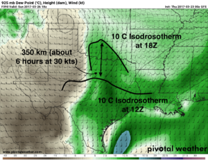
Many people have pointed out the rapidity of the moisture return on Sunday morning. Just based on tonight's 00Z GFS solution, I'd argue the moisture has plenty of time to get here. Tracking the 10 C isodrosotherm at 925 mb, it moves 350 km in 6 hrs, or about 30 kts, which is pretty close to what the wind speed at 925 is. The fact that the moisture moves consistently with advection gives me confidence that it's realistic and not some funny business with the GFS land surface model. I just used the 12-18Z Sunday time period, but the speed of moisture return is consistent from 00Z Sunday morning (Saturday night) onward.

925td.us_sc_annot.png

Again, this is the GFS forecast verbatim, so there's caveats. If the boundary from the Friday wave stalls out farther south than the GFS thinks, then this might change. However, even in that case the nocturnal boundary layer jet that develops on Saturday night might save us.

The fly in the ointment with these rapid moisture return events always seems to be cloud cover, as warm air advection tends to go with moisture advection. Verbatim, the GFS slacks off on WAA between 12Z and 00Z, suggesting it thinks any clouds should break up by go-time. I'm not sure that's reliable in a 96-hr forecast, so I'll say that's still on the table.

There's also still some placement and structure issues to be worked out with the mid-level shortwave trough, per the ensembles (even though this morning's 12Z GFS and ECMWF agreed ... pretty well, actually, on the location and structure of the wave at 12Z Sunday morning). IMO, the cloud cover and the wave placement are the biggest unknowns with Sunday.
 
All great points to consider before hoping in a car and driving 14 hours to an early season target that may or may not verify. Am really curious to see what the 12Z NAM today does with this as the GFS has consistently advertised the low/quality moisture concerns after the last several runs. Another concern I've noticed on some of the soundings is saturation in the mid levels, though low level shear looks great! Tim's point above is great and has me leaning toward making a rocket run.
 
If the boundary from the Friday wave stalls out farther south than the GFS thinks, then this might change.

And now the 12Z NAM comes in and makes me a moron. Boundary stalls out much farther south than the GFS. So much so that the LLJ doesn't pick it up until 12Z Sunday morning, which is definitely too late. There's also some drying at 925 mb off the Gulf coast between 21Z Saturday and 03Z Sunday that delays the moisture return. Maybe related to the NAM's shallow cumulus scheme? Maybe some descent bringing down dry air from aloft? I'm not sure. Whatever, I'm getting too into the weeds on a 72-hr NAM forecast ...
 
Last edited:
To me, there's a lot of mode failures here. Having two shortwaves back to back always causes concerns about moisture quality but for me, with how compact this shortwave, the timing has me most concerned.

The GFS continues to be the most progressive of the bunch but we've all seen in the past how it slows down 48 hours or so closer to the event. The ECMWF nails having a stout surface low centered over Altus meaning a I35 corridor event is most likely. However, any delay in the ejection could lead to the moisture being misaligned with the main forcing.

All in all we are definitely deep diving into this setup because well its the first one in OK and I think it certainly has the potential to be a tornadic day but overall the risk of it not is higher.
 
Really not encouraged by the 12Z NAM and 09Z SREF. Moisture return not only questionable, but doubtful. Only a few members even put 60+ dews in DFW, and the ensemble mean is in the low 50s, and it's much worse further north. Also, for some reason the 12Z NAM occludes the wave during the day so that by 00Z the heights fill in, gradients weaken, and the wind fields fall apart. The 12Z GFS does not do this, so go figure.

Since this is basically in my backyard I can afford to wait until Sunday afternoon to decide to chase it, but if I had to make plans right now I'd be unlikely to make the effort.
 
I'm somewhat encouraged by the 12Z 24 March NAM. Though the "juice" doesn't quite make it up to Oklahoma, the dewpoints are forecast to be in the mid-60's in the Dallas-Ft Worth metro area by 00Z 27 March. Given the pretty outrageous shear profiles and decent lapse rates, conditions would be favorable for supercells and tornadoes if that kind of moisture were to materialize. Additionally, the forcing is a bit more subtle south of the Red River, which might favor more isolated storms.

However, the 6Z GFS was pretty stingy with the moisture, bringing only mid-50's Tds to N TX. If that's the case, in the words of the late, great Bill Paxton, "Game over man, game over!"
 
Enhanced risk up for tomorrow in central OK. If DP's get to the low 60's its game on for a tornado threat IMO.
However, the bigger oddity in my mind is the lack of enhanced risk for the DFW metroplex. Forecast soundings look better, moisture return is better, instability is higher, at this point I it seems the DFW area justifies more of a 30% than does central OK.
One thing to note the NAM has been trending an uptick in moisture between 18 and 00Z tomorrow. The trend is your friend?

This is right in my backyard so we'll see how things unfold, I'm particularly interested to see how today evolves. That will be critical in setting up moisture return for tomorrow.
 
However, the bigger oddity in my mind is the lack of enhanced risk for the DFW metroplex. Forecast soundings look better, moisture return is better, instability is higher, at this point I it seems the DFW area justifies more of a 30% than does central OK.

The forcing is more subtle the farther south you get, so they're probably thinking the coverage will be less in the DFW area. Remember that SPC risk areas are primarily about density of severe reports, not intensity or chaseability.

I'm encouraged by the 25/12Z GFS and NAM runs. Both of them bring the 60 F isodrosotherm into southern OK by 00Z tomorrow evening, though I'll be monitoring obs with the moisture and its transport this evening.

One other potential issue that I forgot to mention earlier is that models have been busting badly on the mixing. They haven't been mixing deep enough, which results in deeper, drier PBLs than the models project. This is most pronounced in central OK, though is probably occurring to a certain degree everywhere, and is almost certainly related to the drought and time since significant rainfall. So be aware that areas that see significant sunshine tomorrow are also liable to have the moisture mix out, too.
 
Back
Top