• While Stormtrack has discontinued its hosting of SpotterNetwork support on the forums, keep in mind that support for SpotterNetwork issues is available by emailing [email protected].

2016-05-08 EVENT: KS//OK/TX/MO

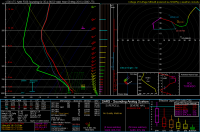
I thought the deepest moisture might be hiding in the region with almost no obs off the coast south and east of Brownsville but the KBRO sounding from 00Z doesn't appear to support that in the slightest. Obviously it's not a death knell to Sunday's setup given there's 24+ hours of possible return flow but we definitely aren't going to be dealing with the same level of moisture we've seen with the previous few southern Plains setups with >67F dewpoints throughout the warm sector. With the aforementioned anvil-level winds being more favorable for less HP modes along with the lower moisture content, we might actually be staring the possibility of decently photogenic storms on the dryline that won't turn into blob of RFD after roughly 30 minutes. Whether or not the backing in the mid-levels materializes also ought to determine this setup's viability but we won't really know before Sunday morning at this point.
 
I thought the deepest moisture might be hiding in the region with almost no obs off the coast south and east of Brownsville but the KBRO sounding from 00Z doesn't appear to support that in the slightest. Obviously it's not a death knell to Sunday's setup given there's 24+ hours of possible return flow but we definitely aren't going to be dealing with the same level of moisture we've seen with the previous few southern Plains setups with >67F dewpoints throughout the warm sector. With the aforementioned anvil-level winds being more favorable for less HP modes along with the lower moisture content, we might actually be staring the possibility of decently photogenic storms on the dryline that won't turn into blob of RFD after roughly 30 minutes. Whether or not the backing in the mid-levels materializes also ought to determine this setup's viability but we won't really know before Sunday morning at this point.
I don't think 67+ degree dewpoints were ever going to be a thing with this setup.

This shouldn't come as a surprise to anyone.
 
I don't think 67+ degree dewpoints were ever going to be a thing with this setup.

This shouldn't come as a surprise to anyone.

I'm well aware. My point was the likelihood of a repeat of the previous few setups with abundant moisture, weak anvil-level winds and messy mid-level flow is almost low given the progged quality of moisture and current observations.
 
Last edited:
Well well well. BRO/CRP soundings this morning show much elusive moisture showing up, albeit quite shallow. I HATE chasing moisture starved events, but it's hard to ignore everything else for tomorrow. Still think the NAM is WAY overdoing dews, but 60s sfc dews with reasonable depth seems possible. 12Z NAM seems to think capping will be pretty strong, but breakable from what I can tell.

I'm expecting a monster or 3 to initiate off the dryline in Western Oklahoma and move east at around 30 MPH. Tornado potential is really high considering the environment storms will be in. Hopefully enough moisture to produce but not too much to have disgusting HP storm modes. Of rather high interest to me is the 0-6 and 0-8 shear numbers being in the 70-80kt range. Should keep things rather discrete and classic, hopefully.

Other than moisture, there's not a lot to dislike.
 
Agree that moisture is the leading concern with this setup. I also think the NAM is overdoing surface moisture. I'm not buying dewpoints in the upper 60s anywhere. However, it has been encouraging to see the SREF holding steady over the last few days keeping dewpoints in the mid-60s right up against the dryline well into KS. However, last night's NCAR ensemble probably has the best handle on the moisture situation, IMO. It progs a somewhat narrower moisture tongue (still more than sufficient for a widespread threat of long tracked storms, though) with dewpoints within 100 mi of the dryline in OK peaking around 65, with most members in the 62-65 F range. Soundings closer to the dryline suggest maybe 60-63 is more likely. Still think that will be enough for a show, though, as that will keep CAPE generally AOA 2000 J/kg assuming the warm sector isn't blanketed all day in clouds and precip, which various models have hinted at all along. That's one possible fly in the ointment, but the model doing the most of it - the NAM - is also the one I believe to be overdoing moisture the most, so I think clouds may not be as widespread as it thinks they will be.

I am a little worried about early initiation. The NCAR ensemble and SREF suggest storms may go as early as 1800-1900. So you may want to consider being in your target area a little earlier than normal for a setup like this. There's also slight concern about storm coverage. The most recent MPAS run in particular (now over 24 hours old) left OK basically void of convection. The NCAR ensemble also only depicts widely scattered/isolated storms in OK. Coverage in KS looks to be pretty certain, though. I may prefer the area beween DDC and ICT and going northeast for better coverage and perhaps less crowds.
 
Wow... the moisture keeps increasing with each model run. Previously, it looked like moisture would be an issue with Tds ~64. Now the 12z NAM is showing closer to ~68. Even if this is over estimated by a couple that would still leave us with mid-60s which is more than adequate. Interestingly, the NAM keeps pushing the DL further east. Originally (84hrs out) the NAM had the DL in Tx Panhandle. It is now in western Okla. This is more in line with the GFS. In fact, a lot of things are coming closer the the GFS solution, including the several days of 500 mb jetstreaks (Sat, Sun, and Mon) coming through. Sunday looks like the big show with the best upper level support but Monday is starting to look better as well given the higher moisture (I will save that for another thread).

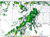
As far as LL shear is concerned on Sunday, the NAM has backed off a bit on the robust region of 50 kts at 850 mb throughout the day (GFS still showing 50+). However by 00Z we are looking at >40 kts resulting in 0-1km shear > 20kts and SRH aoa 300 m2/s2. This is leading to some nice HODOR sized hodographs (GoT reference in there). The cap looks very breakable and there is a nice DL bulge in SW Okla. 4km NAM puts down a nice supercell just south of I-40 and tracks toward OKC metro.

So with my previous concern of moisture being mitigated I think we are game on tomorrow.

Question for the forum... I haven't read anyones post yet until after i post my own thoughts with the idea that i will be completely unbiased in what i write. Do you agree with that philosophy or do you prefer to read others thoughts first and then post?


Somewhere near Weatherford, OK

47fce7087f8eff916b3353ecee248f82.png
 
I have the same concerns regarding moisture, as currently in western OK dewpoints are only in the low 50's. Yet somehow the NAM keeps coming in with higher and higher numbers. I think even low-60's will be enough, however, considering the other parameters. I'm biased toward the NAM, but based on that I was a little surprised to see the SPC shift things further north, and include the whole southern half of central KS in the moderate risk. 500mb winds are not as strong in that region, and soundings much less impressive, with 0-1km SRH not even topping 200, while in west-central, and southwest OK it's over 300. 12z NAM4km fires one dominant cell to the west of OKC along I-40. Right now my plan is to get out early, and head west of OKC, maybe around the Weatherford area, and adjust from there if need be based on real-time data.
 
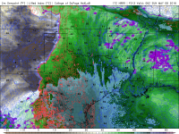
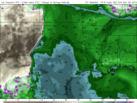
If you are up at 1am check the surface obs and see which one of these forecast Td maps verifies. HRRR has 60 line near waco. Nam has it near Red River.

0d30171e60c0dc483ebc99b04656994c.png

b14f119fbe08534c72a00f4635d4b08b.png
 
Okay...I'm going to bring some of my expertise from a mesoscale analysis standpoint to try to bring some light into why I reject the higher dewpoint values being forecasted by the NAM/GFS and the higher resolution models. In my expert opinion, these solutions are out to lunch in forecasting 65+ F dewpoints for tomorrow at 00 UTC. Keep in mind that this critique is associated with the ingredient of moisture...since that seems to be a key question.

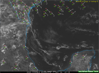
I present the first part of my argument: the 18:15 UTC visible satellite loop in the Gulf of Mexico:
Screen Shot 2016-05-07 at 1.33.56 PM.png
Looping the satellite, you'll shallow-open cell convection scattered across the Gulf. This is associated with the latent and sensible heat fluxes (thanks to Tim Supinie for helping me remember that terminology of the cloud pattern). However, in particular you'll see a couple of fine cumulus lines within the western Gulf. Looping these shows that deeper convection is attempting to develop along these lines, but all air being transported upwards is unable to develop any deep convection. This is evident by the orphan anvils/cirrus shield that get transported eastward, which also suggests that the moisture ahead of these lines are being transported upwards. These boundaries are being advected into the region where NWP suggests we'll get better moisture, and if you look behind the boundaries, there's less cumulus convection, which suggests drier and more stable air may be replacing our "moister" air source. I don't know much about the properties of these boundaries...I can't find much literature on them. However, the observations seem to support my hypothesis. These features are unable to be resolved or analyzed by NAM/GFS, and correctly analyzing them in the storm scale models may be possible, however with limited observations in the Gulf, it's unlikely they are able to correctly initialize them. My guess is that largely given the small scale nature of these boundaries, they may wreck havoc in NWP moisture forecasts as they are unable to a) correctly analyze these features and b) their existence and modification are largely dependent upon the boundary conditions of the model/parameterization schemes. Scientific literature suggests that in severe storm environments, water vapor has the largest variability compared to other variables (e.g. temperature, wind), and therefore it may be more of a failure mode than other variables.

Second, the 12 UTC NAM and GFS ( shown below) are severely over estimating the surface dewpoints within the northwestern Gulf. Per the observations above, much of the Gulf is characterized by dewpoints in the 50s, with very little cumulus convection occurring. If we look at todays lower-resolution NWP runs, we'll see that by 18 UTC they are advertising lower 60s surface dewpoints. Both models are generally running too high in surface dewpoints 24 hours before the said event in that air behind the aforementioned boundaries. Although this is not considered to be our moisture source region given the synoptic scale features, satellite observations don't seem to show any significant differences in the air mass characteristics both in the northwestern Gulf and the air behind the southwestward moving outflow boundaries.
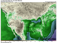
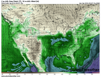
sfctd_b.conus.png sfctd_b.conus-1.png

That being said, I'd tend to go on the lower end the model guidance with surface dewpoints (e.g. lower 60s) rather than the excessive 65+ F being advertised by the NAM/GFS for tomorrow. If we want higher moisture, I get the sense we'll have to consider other sources. At least from my diagnosis, the current observations suggest that there aren't many processes that could help increase Gulf moisture in the near-term (~6 hour forecast).

Consequences of this modification to the NWP forecast may lower the tornado threat for tomorrow evening, but I would say that other forms of severe weather are certainly possible with lower moisture content. Ingredients can work to support one another in forming and maintaining storms. If you discuss weaknesses in a forecast, please be sure to clarify the consequences of said weaknesses! Weaknesses in the ingredients may cause issues in storm initiation, maintenance, and demise. It's important to specify where in the forecast such weaknesses may play a role.
 
Last edited:
I won't be chasing tomorrow, since its Mothers Day, and I've opted to spend it with family. However if I were chasing I would probably target Central Oklahoma from Lawton to Oklahoma City. As the above posters have alluded to, their is question as to if the moisture will make it up there. I too believe that the 12z models are over-estimating dew point temperature. However I still think even with lower 60s dew points (given they occur) there will be at least the threat of a few tornadoes with any discrete supercell that develops along and east of the dry line.

I like Central Oklahoma being right at the exit region of the mid level jet, in addition it looks like a shortwave is coming through right around 21-00z too, which should provide the lift needed to develop storms. I wish 850s were more backed further south along the dry line, however we do have a southerly component to the low level jet, which given that the mid level flow isn't meridional this time, shouldn't be too terrible (I don't think). With fairly steep low level lapse rates (~8.5C/KM), we shouldn't have too much issue developing at least moderate instability across the dry line (~2000-2500) either. I'd probably sit somewhere around Anadarko to Chickasha area (similar to last Friday). Will have to see how things evolve tomorrow morning!
 
This looks like a simple case where any consideration of the actual observations will suggest that the model moisture forecasts might be in question. As of 21z this afternoon, the NAM looks to be several degrees F too high across S TX with the dewpoints, as well as along the slow-moving front up toward nrn MO. I can't say for sure if it's the land surface model, the PBL scheme, or what's causing the excessive moistening, but it's been a problem since at least last year.

People tend to see what they want to see in the model forecasts, and something like the NAM now showing upper 60s can be enticing. Now, I'd like to know the last time anyone can recall upper 60s in wrn OK when the Tds were 4-8 F lower than that 24 hrs earlier across even the TX coast (aside from the lone 67 F at BRO)? That doesn't mean we won't see any tornado threat tomorrow, but I'll believe a 68 Td in OK when I actually see it.
The NAM is consistent with its over forecast of dewpoints. My guess is we will see 62-65* dewpoints West of I35 tomorrow. That still results in a tor threat but I think it minimizes the risk of sig tor quite a bit.

I wouldn't be surprised to see the mdt peeled back to an enhanced unless the 00z runs continue to show substantial moisture. You would expect the NAM to start caving on moisture at 00z or 06z.

Sent from my SM-N920V using Tapatalk
 
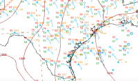
Agree with the above concerns on moisture. I'll add the WPC surface analysis from 00Z, which is ... not good if you'd like to see mid-60's F dewpoints in western OK. I'm thinking 60-63 F is most realistic, maybe with a few 64 F thrown in there.

upload_2016-5-7_23-45-50.png

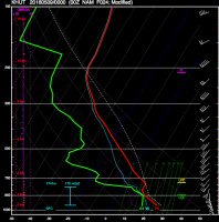
However, I'll point out that even if you modify the NAM forecast soundings for low 60's F surface dewpoints, the LCL's are still within the inter-quartile range for tornadoes. The sounding below is the 08/00Z NAM for Hutchinson, KS modified for 61 F surface Td's, which gives an MLLCL of 1015 m, which is right about the median for significant tornadoes in that area.
upload_2016-5-7_23-51-41.png

The other thing you have to worry about is the lackluster moisture contributing to a cap bust in south central KS and OK, which becomes a very real possibility with the most recent NAM. Granted, Hutchinson is a little far east from where I'd like, but there's a hole in the Bufkit profiles in SHARPpy where I'd like to click. I'll be monitoring the moisture trends in the morning, and I'm considering heading out. Would probably target Alva, OK given the information right now.
 
I'll be targeting Harper, Woodward, and Woods counties. Exit region of the H5 speed max, ~-13 @H5, and lower 60s dewpoints. For a good tornado, I would prefer a 13 g/kg lowest 100mb mean mixing ratio. This is based on sounding thermodynamic structures I looked at a few days ago for this event. I don't think we'll get a 13', maybe if we're lucky a 12' is potentially in the cards. The 12z FWD raob showed an 11.7 g/kg mean w.
 
I saved a 3z surface obs last night and compared to 13z. Tds across central and northen texas increased by 5-6° F. 4km NAM is still showing mid 60s for oklahoma during afternoon. Per mesonet we are already seeing 60-62 so a 65 seems possible. No idea how deep the moisture will be though.

On an upbeat wish cast note... 4km NAM firing cells along the DL near Ok/Tx border and sending ENE.

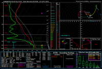
Took this sounding on SE side of storm near Fort Cobb.

01d5cf03d6530ae94fd4d341540c90b7.png

5825993e40084b631588838e6198d234.png
 
Back
Top