2016-05-07 EVENT: CO/KS/NE/OK/TX

Joined
Jun 16, 2015
Messages
476
Location
Oklahoma City, OK
After a relatively quiet work week for severe weather, it looks like the next notable threat in the central U.S. will probable return in time for the weekend on Saturday.

Around this time, there is good model agreement that the omega blocking pattern will break down, allowing for the next trough to eject eastward from the Southwest/Four Corners region. Moisture return looks modest with low to mid-50s dew-points progged over much of the High Plains, but this should be enough given steep mid-level lapse rates to generate marginal to locally moderate instability. Look for storm potential in two zones, just ahead of a dryline from western Kansas into the OK/TX panhandles and closer to the triple point, somewhere near the CO/KS/NE border vicinity.

My guess is that the hot spot ends up being western Kansas, but this is far enough out that details, including low placement, can change. Colorado may be on the western fringe of this threat, but if the lee cyclone parks itself over eastern CO, we could see a narrow corridor of instability nudge into the northeastern part of the state. Likewise, if the system remains a bit farther south, appreciable instability may have trouble penetrating north into western Nebraska. Either way, those states have been included for forecast uncertainty and the fact that they were outlined in the 5/3 day 5 convective outlook by SPC.

Other caveats to be considered:
Sizable temperature/dew-point spreads with southward extent, limited shear (looks marginal along the dryline), 00z TUE ECMWF showed issues with VBV in the wind profiles.


After a week off from chasing, I've been eyeing for a return to the Plains on Saturday and as the event draws closer, confidence continues to increase.
 
Last edited:
Perused the 12Z GFS today and I'm not really sold on moisture return, especially with thru hour 72 showing almost a complete scour of moisture it seems. Worth watching, but I am skeptical.
 
Skeptical seems to be the way to go with events recently. The 12z Euro (like the 00z) shows mid-50s dew-points throughout the threat area with dews into the lower 60s as far north as southwestern Nebraska. Instability isn't overly impressive, but the High Plains doesn't need extreme instability or 60+ dew-points to get things done.

It may be more of a local chase than anything (not worth a long trip for most), but it's hard for me to pass up even a modest threat in the High Plains...
 
The setup has evolved a bit to where there may be a severe threat extending east along a frontal boundary into portions of the Midwest as well as the initial focus on the High Plains.

The new 12z Euro shows a ribbon of modest instability and low to mid-60s dew-points from Missouri into north-central Kansas Saturday afternoon. Back by the surface low, despite dew-points in the 50s, the Euro still muscles out 1500-2000 J/kg SBCAPE amidst steep mid-level lapse rates from far eastern Colorado into western Kansas. The morning NAM, which should be taken VERY cautiously this far out, was progging CAPE over 3000 J/kg in northeast Colorado.

Even if some of the lower-end instability scenarios verify, I think this has the potential to be a nice little event in the central High Plains. Probably much more of a question mark to the south along the dryline due to marginal moisture/instability.
 
The question is exactly how the lee cyclone evolves and therefore where the triple point ends up. Unless something changes dramatically, nothing south of I-70 has any tornado potential with mid 50s dew points out ahead of the dryline and therefore LCLs as high as 1800 m in some of the model soundings I was looking at. Therefore the focus should be along the warm front and back toward the triple point.

Looking at tonight's 00z NAM, it has a ribbon of moisture stretching backward into Colorado enough that there could conceivably be two plays: a northeast Colorado storm at the triple point, say Sterling-Fort Morgan-Akron area, and another one farther east, maybe McCook or a little SW of there, where either the dryline or convergence along the warm front (or both) is enough to get storms going since there's modeled to be little to no cap left by ~21z. Personally, it's that second area I like better right now - not that I'll be doing anything but watching storms on radar from here on Long Island...


Caveats:
-Potential VBV, though seems slight for now.
-Moisture return - 60 F dew point absolutely can get the job done at that elevation, but do we materialize that?
-Storm motion - generally northerly or a hair east of due north with meridional mid-level flow (Bunkers Right vectors are around 190 deg). Thankfully motions are only calculated AOA 20 kts, but regardless, storms could be hopping north over the surface warm front and becoming elevated somewhat quickly rather than riding along it for several hours.
 
My concern in CO isn't the moisture, as tornadic cells in this area tend to pop with no issue borderline 60Td, sometimes lower. The concern to me is CAPE. From a climatology standpoint, this area typically requires much higher CAPE (in this case from surface heating) to produce tornado cells than currently predicted: 2K J in a narrow band simply is not enough IMO, as typically the NE CO supercells prefer 3K+ J. Shear is never an issue here, as the strong downslope/upslope interaction induces vorticity in the 0-3KM range like no where else on earth. Target: Somewhere west of Goodland, KS.

The border of KS/NE along the warm front is quite interesting, as I expect storms to fire, however shear is mostly bad. All in all I don't expect much out of Saturday, however you might fight one or two mature supercells near the triple point in the best case scenario. Save your gas and wait for Sunday in KS or Monday in NE/KS/MO/IA, which could be an all-day show.
 
The question is exactly how the lee cyclone evolves and therefore where the triple point ends up. Unless something changes dramatically, nothing south of I-70 has any tornado potential with mid 50s dew points out ahead of the dryline and therefore LCLs as high as 1800 m in some of the model soundings I was looking at. Therefore the focus should be along the warm front and back toward the triple point.

Looking at tonight's 00z NAM, it has a ribbon of moisture stretching backward into Colorado enough that there could conceivably be two plays: a northeast Colorado storm at the triple point, say Sterling-Fort Morgan-Akron area, and another one farther east, maybe McCook or a little SW of there, where either the dryline or convergence along the warm front (or both) is enough to get storms going since there's modeled to be little to no cap left by ~21z. Personally, it's that second area I like better right now - not that I'll be doing anything but watching storms on radar from here on Long Island...


Caveats:
-Potential VBV, though seems slight for now.
-Moisture return - 60 F dew point absolutely can get the job done at that elevation, but do we materialize that?
-Storm motion - generally northerly or a hair east of due north with meridional mid-level flow (Bunkers Right vectors are around 190 deg). Thankfully motions are only calculated AOA 20 kts, but regardless, storms could be hopping north over the surface warm front and becoming elevated somewhat quickly rather than riding along it for several hours.

My concern in CO isn't the moisture, as tornadic cells in this area tend to pop with no issue borderline 60Td, sometimes lower. The concern to me is CAPE. From a climatology standpoint, this area typically requires much higher CAPE (in this case from surface heating) to produce tornado cells than currently predicted: 2K J in a narrow band simply is not enough IMO, as typically the NE CO supercells prefer 3K+ J. Shear is never an issue here, as the strong downslope/upslope interaction induces vorticity in the 0-3KM range like no where else on earth. Target: Somewhere west of Goodland, KS.

The border of KS/NE along the warm front is quite interesting, as I expect storms to fire, however shear is mostly bad. All in all I don't expect much out of Saturday, however you might fight one or two mature supercells near the triple point in the best case scenario. Save your gas and wait for Sunday in KS or Monday in NE/KS/MO/IA, which could be an all-day show.

Purely from a thermodynamics standpoint, this setup reminds me of 22 May 2008 (the Windsor day). I studied that case in some detail in my Masters work and I remember the very narrow tongue of higher theta-e air running along the cool side of the warm front (really was more of a dryline/occluded front as there was cT air south of the front in E CO, which is exactly what the GFS has been depicting). So in response to Royce's post, I don't think CAPE is going to be that much of a concern. 2000 CAPE is well more than enough to get tornadoes anywhere. You also don't need anywhere close to 60 degree dewpoints in E CO. Mid 50s is typically more than enough, especially with 500 mb temps of -15 C.

IMO, the biggest issue is whether or not this specific scenario actually verifies, and if so, to what extent. Such a narrow tongue is likely not going to be sampled by the dearth of observation platforms in E CO, so don't expect to see this by looking at METARs. Gridded analyses, satellite, and radar are going to be the most helpful tools. I think if a storm can manage to not fly off into the mP air north of the warm front too quickly, there's a decent shot at a tornado or two. Deep layer shear suggests any storms would be wonderfully sculpted and LP-classic in morphology.
 
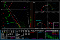
Just an insane (and quite scary) look on the 12z NAM 4 km nest. It blows up a supercell at the KS/CO/NE triple point around 22-23z, and this is the environment it's feeding off of:

I love these mesoscale days. You need to do some real-time detective work, and it (sometimes) keeps the throngs of chasers away.nam4km_2016050512_060_39.89--100.67.png
 
I am completely concerned about moisture at this point, and the concern goes into Sunday as well. 12Z RAOBS this morning show very dry air along the gulf with offshore flow. The buoys in the gulf aren't much better and continue to show slow moistening over the past few days.
 
@Ben Holcomb - no kidding. This doesn't look very promising. Funny that the Euro, GFS and NAM all show the presence of low to mid 60 surface dews going into Sunday.

From COD (Hi Res Raw Surface Plots):
Bouys.PNG
 
What a weird setup. I'm not sure I'm qualified for this kind of forecast, but I'll give it a shot. Also might want to add WY to the thread title.

None of the models seem to have a good handle on where the best tor potential will be, but my bet would be near the DCVZ east and north of Denver, maybe all the way into Wyoming, where the surface low moves through and wraps moisture around the northwest side. Associated Theta-e should be the focus for early convection as early as 1-2 pm. My main concern, along with marginal moisture, is very backed upper levels in response to the closed upper low. On the northwest side of the surface low, some models are indicating southeasterly-easterly flow above 300 mb. This combined with relatively little directional shear in the mid levels would lead me to believe that northwest moving clusters, as opposed to discrete, sculpted LPs, may be the favored storm mode. Tor potential does seem to be there give the abundance of low-level CAPE and vorticity to aid in stretching. Near the low, 0-3km CAPE values near 150ish exist and are more than sufficient for tornadoes. That seems to be the biggest factor with the low moisture upslope days.

Farther east near the warm front in NE, similar parameters exist but SRWs are weaker on some models. This is also farther east of the DCVZ, high plains magic zone where you actually need moisture for tornadoes. Moisture pooling should help, but models are likely overdoing it by a few degrees given the aforementioned crappy Gulf Tds. Overall, it seems like low 50s dews are likely, maybe crawling into mid 50s along the warm front. The only place that I would trust to get tornadoes in that kind of environment is Colorado, where we have all been trolled time and time again. Tomorrow again looks to be one of those days. I wouldn't be surprised if someone scored along the warm front in central/southwest Nebraska either. With the ridiculous variance of parameters between models/model runs/distance, whether or not I chase will hinge heavily on mesoscale details, and the 8 hour haul to Colorado would have to begin around 5 am to make it in time for initiation. As a result, I will likely sit this one out to prepare for finals next week, so expect Saturday to be the biggest of the three days. Whatever happens, I'm sure @Max Olson will somehow score a beautiful tornado in Colorado Saturday.

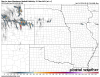
Here's a nice UH map from the 4km that will likely be the only thing anyone looks at in this post.

6fb7f2abf6f99817dc598dbf1f51f840.png
 
Last edited:
What a weird setup. I'm not sure I'm qualified for this kind of forecast, but I'll give it a shot. Also might want to add WY to the thread title.

None of the models seem to have a good handle on where the best tor potential will be, but my bet would be near the DCVZ east and north of Denver, maybe all the way into Wyoming, where the surface low moves through and wraps moisture around the northwest side. Associated Theta-e should be the focus for early convection as early as 1-2 pm. My main concern, along with marginal moisture, is very backed upper levels in response to the closed upper low. On the northwest side of the surface low, some models are indicating southeasterly-easterly flow above 300 mb. This combined with relatively little directional shear in the mid levels would lead me to believe that northwest moving clusters, as opposed to discrete, sculpted LPs, may be the favored storm mode. Tor potential does seem to be there give the abundance of low-level CAPE and vorticity to aid in stretching. Near the low, 0-3km CAPE values near 150ish exist and are more than sufficient for tornadoes. That seems to be the biggest factor with the low moisture upslope days.

Farther east near the warm front in NE, similar parameters exist but SRWs are weaker on some models. This is also farther east of the DCVZ, high plains magic zone where you actually need moisture for tornadoes. Moisture pooling should help, but models are likely overdoing it by a few degrees given the aforementioned crappy Gulf Tds. Overall, it seems like low 50s dews are likely, maybe crawling into mid 50s along the warm front. The only place that I would trust to get tornadoes in that kind of environment is Colorado, where we have all been trolled time and time again. Tomorrow again looks to be one of those days. I wouldn't be surprised if someone scored along the warm front in central/southwest Nebraska either. With the ridiculous variance of parameters between models/model runs/distance, whether or not I chase will hinge heavily on mesoscale details, and the 8 hour haul to Colorado would have to begin around 5 am to make it in time for initiation. As a result, I will likely sit this one out to prepare for finals next week, so expect Saturday to be the biggest of the three days. Whatever happens, I'm sure @Max Olson will somehow score a beautiful tornado in Colorado Saturday.

Here's a nice UH map from the 4km that will likely be the only thing anyone looks at in this post.

View attachment 13309

Good post Taylor, I am not sure I am qualified for this kind of forecast either but I agree with you completely. In northeast CO this level of moisture is sufficient and you have the influence of upslope and the DCVZ - yet 500mb winds are backed. Farther east along the warm front along the southern NEB border, the 500mb winds are more southwesterly and divergent, but moisture may not be sufficient at that lower elevation.

Might be more chance of a sculpted LP further south along the dryline??


Sent from my iPad using Tapatalk HD
 
Back
Top