• While Stormtrack has discontinued its hosting of SpotterNetwork support on the forums, keep in mind that support for SpotterNetwork issues is available by emailing [email protected].

2016-04-24 EVENT: OK/KS/NE/IA/MO

Joined
Mar 30, 2008
Messages
1,488
Location
Norman, OK
With next week looking to be particularly active, I think we can start looking ahead. Sunday appears to be the first 'chase' day for us based in Central Oklahoma with supercells possible, especially in SW, South Central and Central OK. The GFS is showing a nice 996 low in Western Iowa with a secondary low near Childress at around 998mb. Moisture return isn't the greatest, but mid 60 degree dewpoints seem reasonable with decent turning in the lower levels.

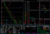
500 mb flow seems to be mostly westerly at 35-40 knots with CAPE in the 2000 J/KG range. Upper levels are still a little weak, but it's a day before the day before the day - ha

Here's Norman and Purcell 00Z forecast soundings

39c429285d59953f5471d52139da3e36.png

b3e1164ef0412d605b2f6e384495161b.png
 
The day before the day before the really bid day is starting to look pretty good. Mid 60 Tds combined with a decent LLJ should be good enough to prompt some tornado warned cells. Looking at SC Kansas and NW Okla. The main jet is further north, but we should be able to get some storms to fire along the front and dryline.

8d5db44e31686aa7c262ca4193073702.png

a6fc3af4e62ee1b296b9f5903501c044.png

3af04c7b48e5e5fa74604631c970fd59.png
 
If the 12Z NAM is to be believed, Sunday is absolutely a chase day! Incredible lower level turning evident in plenty of soundings from Enid to Wichita, adequate moisture that Brian posted about and decent instability. Even if the NAM is overdoing all parameters, it seems like a good supercell day nonetheless.

Planning to head north on I-35 as it stands.
 
Noticing some issues with shear with this setup. Especially in the vicinity of NC OK/SC KS, the 12Z NAM is consistent with past runs of the GFS with some weak shear above 2 km (although great below that). Farther to the northeast, in E KS, there are indications of S-shaped hodographs. Shear looks better in SW OK, however, where there is a bit more shear between 2 and 6 km along with the still strong low level shear below 2 km. However, in that same area, anvil relative flow looks to be a little weaker, so storms could be more on the HP side in that area.
 
Noticing some issues with shear with this setup. Especially in the vicinity of NC OK/SC KS, the 12Z NAM is consistent with past runs of the GFS with some weak shear above 2 km (although great below that). Farther to the northeast, in E KS, there are indications of S-shaped hodographs. Shear looks better in SW OK, however, where there is a bit more shear between 2 and 6 km along with the still strong low level shear below 2 km. However, in that same area, anvil relative flow looks to be a little weaker, so storms could be more on the HP side in that area.
was just coming to post that as well. Additionally I feel that with the track of the primary wave, forcing for ascent on the large scale will be relatively weak. There does seem to be an embedded shortwave that could aid in development some.

Looks like an isolated severe type day, which is fine with me given the Tuesday event. I don't think we'll see too many storms Sunday, and I top question the shear with anvil level flow in particular in question.
There's a weak impulse south of the main jet that looks like it'll give us a glancing blow of some decent forcing for ascent but the problem seem to be the weak ventilation winds and almost total lack of strong steering aloft which will have us sitting with south moving, wobbling HPs.

Sent from my XT1080 using Stormtrack mobile app
 
Just checked out the 18z NAM and GFS. NAM is higher with moisture. GFS keeps Tds in the lower 60 while NAM puts them in the upper 60s. Not necessarily believable but the GFS does paint a possible chase Target in SW oklahoma. As Jeff alluded to the shear is a little better down there.

NAM keeps things further north into NW OK and SC KS. I cherry picked this sounding for NW Oklahoma and immediately fell out of my chair (Just like in the genius GIF that is going around).

bec29c5e4a989e91e21cfdbf1bf6e754.png
 
I'm a little surprised SPC didn't even put wording in for an "isolated tornado" threat or a "conditional tornado" threat. Oh well. I still think we might still be okay if we can get a little better low lvl helicity and a cap break. I think Nam is a little bullish on the instability. But I'm optimistic.

Oh, and I agree with the ventilation concerns. BUT IT'S THE WEEKEND...SO NO PTO NEEDED

Sent from my SM-G920I using Tapatalk
 
Definitely worried about initiation, but if we get initiation, the 12Z NAM today paints a very nice environment up around Blackwell. Good turning, decent moisture and prospects of a tornado at dusk much like last Friday. I'm really digging the sicle-shape to the hodograph.

3da7b3e80d9daadfa27263836fc69c18.png
 
Suggesting that (if the NAM verifies) extreme NE Kansas to SE Nebraska and W Iowa may have the best tornado chances before dark. (May want to add SE Nebr. and W. Iowa to the subject line?)
NAM is showing a nice alignment of Bulk Shear, supportive of supercells, with SBCAPE of 2400 (even if that is overblown it should leave more than enough to work with), 0-1 EHI of 2.9, and both good 0-1 Helicity and SRH. CIN should not be a factor by 0z. LCLs are under 1000 meters and get better as you move into SW IA.

Way to early to pick a target, but right now I would suggest Red Oak, IA as providing an interesting model Skew-T:

d2f4eeda05eee281f6fb2f9a33242708.png
 
Definitely worried about initiation, but if we get initiation, the 12Z NAM today paints a very nice environment up around Blackwell. Good turning, decent moisture and prospects of a tornado at dusk much like last Friday. I'm really digging the sicle-shape to the hodograph.

Wow, that's the 12Z NAM? there's a dramatic shift in anvil relative flow in that sounding compared to previous runs...in a trend that's for the better (i.e., storm mode may be less plagued by precip covering the meso). Makes me wonder if the 12Z NAM has a more southerly jet or just an expanded jet stream/streak (I haven't looked at it).

Would like to see somewhat higher moisture content. I would've thought better moisture would make it to Oklahoma by Sunday, but I see currently that flow in the NW Gulf is just barely turning back onshore, so maybe moisture return will end up being a problem. The MLLCL in that sounding is a little high, but forecast soundings for last Friday's event in the TX/OK PHs had similar LCLs, and we saw what happened there (although I think the actual LCLs may have been lower than those progged).
 
The 12Z 4km NAM has really got my attention now for tomorrow. My biggest concern up this way was the NAM kept showing storms going up by 21Z along some kind of prefontal trough and zipping into Iowa, and then at 0Z when the LLJ really gets going, it wasn't really firing too much back in the "good area". The 12Z 4km now has a line of broken sup's from Nebraska all the way to Oklahoma at 0Z behind the initial stuff that's way over in central Iowa. Also winds look a little more backed so there is good convergence and of course better low level shear. I'm seeing nearly 35 kts of 0-1km shear and a ton of low level CAPE(140+) up in southeast NE and southwest IA.
 
It could be risking a cap bust playing this far south tomorrow evening, but the NAM-4km has quite the cherry picked sounding from west of El Reno on I40 tomorrow evening. It has also broken out precip that far south into Oklahoma on every run so far. Not exactly sure where I will target yet, but if Oklahoma looks like it's going to go, it would be fun to be there. 5b26b3f515f233a09a1fa80aa88fa515.png
 
I am getting a bit concerned about the setup for Sunday. 850 winds look good enough, but the big problem looks to be moisture. Currently 9:45 pm central, Mesonet is showing Upper 50s Tds in SW Oklahoma. Normally, i would think sweet, i bet the good moisture is waiting to advect north from Texas. But a look at the High Res surface obs is disheartening. Where is the moisture? I can't find but a handful of 60 Tds in Texas. Futhermore, the gulf is looking very good either. So unless we get some exceptional moisture advection i would anticipate tornado chances to be limited tomorrow. Nevertheless, I nice LP supercell would be a good treat.

98fb0f9dbf2c891653c2cac208d5f9d2.gif
 
Just looked at 00z 4km NAM. Still not sure about the moister but it is developing isolated supercells along the DL. One in NC Oklahoma. Pulled a sounding on southeast side of storm in NC Okla at 00z and all i can say is yippe ki yay.

What exactly does PDS TOR mean? Now if we can get those Tds into the mid 60s, i would be worried. Target is Enid.

6a0290a4e0c4097f995a2a3afde7cf37.png

75a975ca469071d3a2e9d03978f7848e.png
 

Attachments

  • aba49831b91a14cbdb621bb7110d860c.png
    aba49831b91a14cbdb621bb7110d860c.png
    213.3 KB · Views: 163
Back
Top