• While Stormtrack has discontinued its hosting of SpotterNetwork support on the forums, keep in mind that support for SpotterNetwork issues is available by emailing [email protected].

2016-03-23 REPORTS: IA/MO/OK/AR/TX

Joined
Aug 9, 2012
Messages
586
Location
Macomb, IL
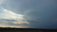
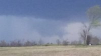
Decided to take the chance and chase yesterday near the surface low in Northwest Missouri/Southwest Iowa. Original concerns over marginal moisture ended up verifying and setting this back from what could have been. Bulk shear in excess of 65 knots and CAPE values ~1000 J/KG set the stage for possible tornadic supercells across the area. We headed out toward the Tarkio, Missouri area and watched and several storms initiated and none appeared to really be able to establish a solid updraft, thus "pulsing" up and down. Managed to finally get on a halfway decent looking storm around 6:20PM between Burlington Junction and Quitman, Missouri. This storm had some halfway decent high based structure, before another cell come up from the south and cut it off. The southern cell near Quitman, Missouri produced a funnel which I thought was going to develop into a tornado, however the entire updraft quickly became occluded. It tried to produce a new area to the east; however, I think the lessening instability at this point and somewhat meager mid-level lapse rates working into the area, caused this to not quickly fall apart. After this storm fell apart, we called it a day around ~7PM and headed east for home. Overall a somewhat disappointing chase day, given the potential for at least a couple tornadoes in the area, but you can't win if you don't play....at least something to that tune. Hoping for better setups in the future. (See photos below)...

34619541bc04c779ec2856560e6bcc3f.jpg
Burlington Junction, Missouri structure

ad8ee3b272921671a93bb40b7621f514.jpg
Funnel cloud near Quitman, Missouri
 
Mods: Could you add Oklahoma to the title.
Decided to head out to my target area of Checotah. Wasn't expecting much but I had the day off work and figured I would see if I could get something decent before things went linear. First storm went up just to my Southwest. Dropped down South when I realized there was an even better storm South of that one. Ended up catching a nice cell near Atoka, OK. Not too bad of a chase for March.

This first pic made me realize just how badly I need a zoom lens

5674ebc7e94ee928282f3ab3b6d3d3b8.jpg

fcce09c812d932038fd1f142694a5a75.jpg
 
We too were on the cell near Burlington Junction. Saw a really nice RFD and funnel with this one. Unfortunately, moisture was not as robust as predicted by the models, so that affected the integrity of the storms. They didn't have enough juice and buoyancy to combat the neighboring cells.

6de6c73272863036d2ec78ccbef13bdc.jpg
 
I headed out late to intercept the storms coming in from the Atoka area. Because of trees and mtns I decided to perch up on top of the Talimena scenic drive and just wait it out. It wasn't long before the storm was tornado warned (near Clayton) and I had a great view as it came into Talihina and then towards Heavener. It looked pretty good when it was back near Clayton.e1b59ffa8f4525bf23e2e5ca731f4755.jpg

10201b34623657966f2150c41bc364fa.jpg

And on approach to Heavener 91f032bc35cafb2a3a23078e1c1af33e.jpg

6182eea44733d1d1013dc4a9b5e8c4d8.jpg


Sent from my iPad using Stormtrack mobile app
 
Targeted Atoka with friend Tammy Stanford . Moved to a nice hill west of Tushka and watched the cell in Love county until the core got to close . Moved east on highway 3 and watched a nice wall cloud south of the highway , but quickly became rain wrapped. Moved north on a county road as a funnel formed over head , but gave up chase due to sun going down.
 

Attachments

  • atoka 3.jpg
    atoka 3.jpg
    22.7 KB · Views: 152
  • atoka 2.jpg
    atoka 2.jpg
    25.3 KB · Views: 160
  • atoka 1.jpg
    atoka 1.jpg
    43.2 KB · Views: 149
Add Texas to the list.

Easiest "chase" of my life, as i drove a mere 10 minutes up to Lake Lewisville and sat on the boat ramp for about an hour and a half just watching the storms develop and lightning go nuts.

DSC_5611.jpg DSC_5970.jpg

I took a peek at RadarScope and noticed a huge notch out near Haslet, with strong rotation, and on a path for my location. So I decided to head back to my apartment where I'm on the 3rd floor and have a nice clear view to the west. It looked like it would go just to the south. Well as I was driving back, the rotation was cut off, and outflow took over, but I still got some great shots from the comfort of my balcony!

DSC_6569.jpg DSC_6677.jpg DSC_6756.jpg DSC_6866.jpg

As the storm overtook me the hail began to fall. I collected a 1" stone from my balcony, but I'm sure bigger stones were falling. Added several more dents to my car, but no broken glass!
 
I decided to chase Wednesday to get familiar with the area a little more and get some practice (new to Nebraska, new to chasing). I had been watching the HRRR, GFS, and NAM all day on PivotalWeather and decided to target SW IA/NW MO. Unfortunately I got off work later than planned and made it down to Nebraska City at about 5-5:30P (first mistake, I was still acting on my original plan that had me in Nebraska City about 1.5-2 hours earlier). I finally checked the radar and got thrown by NNW cell motion (second mistake). I should have reevaluated and gotten way east before the setup turned linear, but decided to drop further south in the watch area hoping the warmer surface temps and dew points would fuel some more robust convection. It did, but by then I was too far west because everything pushed E and turned NNE while I was en route. In short, I ended up trying to play catch-up but called it when the line pushed into the Clarinda, IA/Burlington Jct, MO area.

It was a complete and total bust, but I learned way more than if I would have stayed at home watching radar. I'd rather make significant mistakes and learn from them while the main risk is my gas budget, not finding myself in a bad spot in a dangerous storm.
 
Back
Top