• While Stormtrack has discontinued its hosting of SpotterNetwork support on the forums, keep in mind that support for SpotterNetwork issues is available by emailing [email protected].

2016-03-08 EVENT: TX/OK

Randy Jennings

Supporter
Joined
May 18, 2013
Messages
841
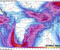
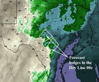
It's way too early to get my hopes up and start picking a target area, but I think we need to keep a watch on Tuesday 3/8 in Texas. Looking at the GFS, it looks like a upper low will be centered over southern New Mexico with a surface low somewhere in northwest Texas with a dryline spanning the state. Sheer looks good with decent Td for this early in the season. CAPE between 1000-3000 depending on time of day and how far south you go. Cap looks breakable. Lift may be the problem on this one. Can we get some surface focus in the right place at the right time? Too early to tell, but I'll be paying more attention as more models come in range.

Edit: After some chat and looking at this some more, I've added OK to the thread.
 
Last edited:
In fact the current re occurring trend based on the GFS and GGEM would suggest that you are very right with your concerns, Randy. Though whilst still a bit early, GFS tends toward the upper low becoming partially negatively tilted by late afternoon Tues! Early season storms as we all know need much more northerly thrust to move moist unstable air northward from the Gulf. Though the added bonus (or concern) as 'we all' may see it is that the strongest upper jet will also occur at this time of year! The combination of the two conditions are certainly worth watching at this point in time and in my opinion out weigh any other days outlook by superiority! Current risk looks to be east TX though plenty of time for variations. The current primary alert is that there is currently a sustained number of model condition which look to become a reason for concern (southern States) for around this time.
PS. GGEM currently delays the transit of the upper trough eastward which might suggest the risk period could translate into Weds. TBH in the past 15 yrs I have never seen a trough dig so far south? Time will tell!
 

Attachments

  • 500mb.JPG
    500mb.JPG
    244.4 KB · Views: 242
Last edited:
I'm not giving up on Tuesday 3/8 yet. I didn't have time to do an in depth analysis, but looking at the SREF plume's I still like Tuesday better than Monday 3/7. Bellow is dews, MLCAPE, and EFFSHR at DFW. OKC and SAT look similar. I'm thinking Central Texas is the place to be on Tuesday. We'll see if we can get lift and if Monday's convection doesn't mess it up. Those boundaries left over from Monday might just be what we need.
 

Attachments

  • 20160308_plumes.png
    20160308_plumes.png
    286.9 KB · Views: 192
Shaping up to be a pretty decent setup for severe weather if you ask me. At least compared to the day prior, there looks to be greater instability and over a more widespread area. Shear looks to also be stronger over a more widespread area. A triggering mechanism is present (both a warm front and a dryline) although convergence doesn't appear too strong along either boundary.

Things that bother me about this setup:
-500 mb winds are only to the SSW/SW, so veer-backing is a problem.
-The trough forcing this event appears to stop west of the region, thus removing DPVA and associated support
-Possibility for widespread junkvection killing off instability

If it stays clear, however, then this day should be a bigger day than the previous day.
 
Would be rather concerned about the after dark potential with this S/E of the triple point across central and southern Texas. Looks like a shortwave rotates through the east side of the main ULL and leads to a re-emergence of the LLJ across these areas after it was shifting east during the day. Near surface flow is out of the SE as well with maintenance of moderately to strongly unstable conditions and minimal capping. Intrigued by the Euro's precip signal, which seems to not show consolidation into a squall line until 12-15z Wednesday.

Synoptically, the whole thing sort of reminds me of the 12/26/15 setup shifted a bit south.
 
Certainly looks like a workable chase day with some uncertainties. Though, not sure how late in the day things could ramp up? Strongest conducive conditions could well peak very late in the evening. 4km NAM updates and currently seems to want to target a region around Southern TX. Though it will probably be residual outflow boundaries from the earlier MSC which will define the actual results. Some very interesting 0-3km EHI prediction; potentially to 8.5. Though on a negative point the atmosphere looks fairly saturated up to the trop which could hinder the cooling of cloud tops.
 
Boy, my optimism has really diminished for tomorrow. Short and sweet...

1. Upper-level energy won't arrive until well after dark
2. Strength of the LLJ seems to be decreasing, at least up in N TX
3. Surface winds out of the SE everywhere. No forcing along the dryline
4. Is there a triple point? I can't really find it. Very murky surface conditions.

The saving grace could be some outflow boundaries from overnight/morning convection. I'm pretty much obligated to stay within a few hours of DFW, so dropping south/southwest of San Antonio isn't really an option. This looks like the spot to be, but there still likely won't be anything on this side of the Rio Grande until after dark. Thanks Obama.
 
I remain optimistic of a conditionally high reward setup across the TX PH and neighboring portions of W OK and NW/WC TX. It really depends on how large a convective system develops and tracks across TX into OK overnight, and how quickly it moves out, as well as how badly it cleans out the moisture. Some prior CAMS have indicated a potential for sufficient clearing to result in cellular storm development along the quasi-stationary front that will develop over the next 12 or so hours. Given the approach of the more significant trough, the front does not appear to be progressive at all, despite the presence of northerly winds behind it. It could very well provide the necessary forcing to get storms to fire. Given sufficient heating, there could be 2000+ CAPE, and only weak capping, so along with more than sufficient deep shear, a supercell couldn't be ruled out. Low-level shear looks to be on the lighter side, though. If I had to pick a target right now, I'd pick one of my least favorite locations in all of chase territory, Armstrong County, TX.
 
I remain optimistic of a conditionally high reward setup across the TX PH and neighboring portions of W OK and NW/WC TX.

Definitely agree with this looking more into some of the mesoscale models, really nice sweet spot setting up there with some very cold (near -20˚C at 500 mb) air aloft leading to impressive mid level lapse rates and rather fat CAPE profiles (assuming not a ton of convective overturning). I like the strongly-backed near surface flow as well. Almost looks more like one of those quasi-cold core setups in the High Plains in June with a relatively stationary upper level disturbance. May be a good bet to "steal the show" more or less from the areas further SE.
 
Welp, that play looks to be out. The fairly expansive MCS across TX and OK is really clearing out the moisture. Even with pretty clear skies in the wake of the MCS across the western half of Texas, multiple obvious outflow boundaries on visible suggest we will not see the return of sufficient moisture to make things truly interesting in NW TX/TX PH. Unless something miraculous occurs with moistening pretty soon, I will sit this one out in favor of better systems later on.
 
If I were out chasing Texas today, I would be targeting somewhere between an Abilene to Brownwood to Lampasas line, and points to the south/southwest of that line. It looks like there will be plenty of recovery time for insolation and TDs aren't scoured out, they are still in the low 60s. There should be plenty of CAPE later on this afternoon as moisture returns north, and there is an outflow boundary meandering around out there as well. Several recent HRRR runs show convection re-firing later this afternoon to the SW of DFW... I think that would be my play today.
 
Last edited:
If I were out chasing Texas today, I would be targeting somewhere between an Abilene to Brownwood to Lampasas line, and points to the south/southwest of that line. It looks like there will be plenty of recovery time for insolation and TDs aren't scoured out, they are still in the low 60s. There should be plenty of CAPE later on this afternoon as moisture returns north, and there is an outflow boundary meandering around out there as well. Several recent HRRR runs show convection re-firing later this afternoon to the SW of DFW... I think that would be my play today.

I agree, and that is where I'm heading, right along that outflow boundary. A storm rooted in the boundary should have a decent shot at producing a tornado.
 
Definitely looking like deep central Texas from Coleman to Brady is the best shot at a decent supercell. Hopefully that OFB doesn't surge too far, the moisture situation is a bit tenuous even with the multiple days of return flow.

Sent from my XT1080 using Stormtrack mobile app
 
For what its worth, tend to agree with above posts regarding the severe potential of this outlook. HRRR is most definitely playing down the earlier 0-3km shear suggested by the NAM!
Whilst this shear is reduced fairly significantly there might still nevertheless be some scope for isolated Supercell development Southern TX if updrafts can tap into the upper layer. The HRRR does at least currently show the potential for surface convergence initiated along the dry line. Image below gives some indication of locations where the HRRR projects dry air extending forward and might develop the best lift from surface. If enough bouyancy can be acquired one or two cell within this zone could well become dominant. Though this may well occur (if at all) after dusk. The upper jet will remain strong and very supportive of severe storms, ONLY if the buoyancy of any storm can make this level. The biggest restriction by far looks to be the very slow easterly moving influence of the upper trough. This is probably the most controlling factor since this thread was started!
Whilst any tornado risk looks fairly remote; this should not be completely overlooked should any isolated tall cell tap into the strong upper support.
 

Attachments

  • dry line copy.jpg
    dry line copy.jpg
    253.1 KB · Views: 135
Last edited:
UPDATE; Current HRRR 'might' indicate region around Boerne (just North of San Antonio) within the next couple of hrs. Though TBH surface ob's from this point onwards might be the best indicator!
 
Back
Top