• A friendly and periodic reminder of the rules we use for fostering high SNR and quality conversation and interaction at Stormtrack: Forum rules

    P.S. - Nothing specific happened to prompt this message! No one is in trouble, there are no flame wars in effect, nor any inappropriate conversation ongoing. This is being posted sitewide as a casual refresher.

2015-07-13 REPORTS: IA/IL/IN/KY/MO

Joined
Jan 14, 2011
Messages
3,089
Location
St. Louis
After a brief diversion to check on an initial storm near Dwight, IL, Greg McLaughlin and I settled on the storm moving into Ottawa. Despite some impressive RFD and promising looks a few times, the storm couldn't get it done - inflow was too weak. The highlight was watching the storm move through the wind farm. Since the turbines automatically turn to face the wind, collectively they were a visual microscale mesonet, revealing the surface flow pattern under the storm. At one point, turbines surrounded the wall cloud, showing the inflow into it from the southeast, east, north and northeast.

july1315a.jpg

At that point was the best the storm looked, and it was all downhill from there. The RFD/forward flank gust front ran far ahead of the storm for the rest of the evening. We broke off the chase at Dwight and headed home, opting to not continue into Indiana given the fading daylight and lack of reports from ongoing storms there.

We also encountered for a moment what was probably a record Illinois chaser convergence (running into Skip Talbot, Marcus Diaz and several others).
 
Last edited:
I chose the same target area as @Dan Robinson and like him, was teased by the initial cell near Dwight before returning to Ottawa to intercept what ended up being the best cell right as it fired up and became severe. I was on the north side of the Illinois River (I hate that river) on Rt 6, west of Ottawa, so I had only one route, and had to duck into a car wash when the hail shaft hit. Here it was up to quarter-size, though I did see stones almost 4" to the south and east of Ottawa when I was able to get back behind the storm. The cell looked good for a bit, but like Dan mentioned, it never produced and went downhill after going southeast of Ottawa. It was a bit ragged, but still photogenic, and there were a few radar signatures that made me think it would reorganize a bit, but it never did. There were definitely a lot of chasers out in the field on this cell. I'm rather new in the community, though I've been chasing on-and-off for 20 seasons now, so I don't know who I saw out there.

Since I live in Cincinnati, breaking off this chase meant heading back toward the cells in Indiana that had received tornado warnings. The warnings had been dropped by the time I got to them, but these clouds were still generating some spectacular CG.

Here's a link to my Facebook album of photos from the chase: https://www.facebook.com/chris.dick...10153488484353421.1073741839.755028420&type=3
 
Chased yesterday with Colin Davis, and my brother Wil. Story is likely the same as many others.

Targeted La Salle/Ottawa and spent much of the afternoon there. We briefly went after the first storm that tracked toward Dwight, but once we saw towers/radar returns over La Salle taking off we aborted the initial storm which had been struggling to get its act together. This turned out to be the right choice as the Ottawa storm did take off and become quite an impressive supercell. It had several wall clouds/RFD occlusions that convinced me we may be 5-10 minutes from a tornado several times, but as Dan said, ultimately it's hard to watch a classic RFD cut but be sitting in calm winds in the inflow region.

Just so odd that I thought surely any supercell that formed would be HP in that environment, and that the isolated supercell window would be narrow before storms started fighting for real estate and ultimately congealing into a bow echo that I'd wave goodbye to. But no, isolated supercells the entire day, which remained in a classic mode with high visibility, and yet not one tornado. Mother Nature, you funny.

2c6dd8bd3211b585c01140db078f9970.jpg

a9048470980ddb17450c773dc8834aa6.jpg

 
I have pretty much the same story as everyone else here. I left my house and met up with chase partner, Kholby Martin, in Galesburg and we left around 3pm. We both figured that any storms that formed and interacted with the morning outflow boundary would have tornado potential given the amount of instability and even the presence of ~200 m2/s2 of ESRH that was not only present on mesoanalysis, but the special 18z ILX sounding. We headed down I-74 towards Peoria and eventually jumped on I-39 heading north targeting an incipient supercell over LaSalle County, IL. We approached this supercell from the rear as it was just getting east of I-39 paralleling it on highway 6 before dropping south through Ottawa. We noted dramatic RFD structure and what even appeared to be an occluding mesocyclone on the back side of this supercell. We followed this cell all the way to just east of Dwight, noting that it appeared to either be undercut by the morning outflow boundary or its own RFD gust front. It never could get fully organized to produce anything more than some large hail (~2.00") we observed on the ground outside Merseilles, IL. I didn't even observe much lightning on this cell either which perplexed me and was the opposite of what I expected given the amount of instability. We headed home around 7pm, calling the day early and arrived back home around 9pm, which is always nice! Here are a few pictures that I shot, mainly with my Iphone, since we were driving most of the time:

c13776f777d0e20897d0bbdbf48cc24a.jpg

Updraft approaching the storm

a8589b4c3ffdbbefb6a1dbcf2574463d.jpg
Occlusion on the back side of the storm coming through Ottawa, IL.

3fb551fcb84cd76fcec7f02c35620ce7.jpg
More RFD/occluded meso structure, same as the previous picture

03c5cc881f6a48e310c27a13bd010b44.jpg
Later on, outside of Dwight, IL. I shot this with my Nikon, so its of way better quality. Pretty disappointing this thing couldn't get it done, but that is just how it goes!
 
The day started off by watching the outflow boundary from the morning storms pass over my house. Then southwest winds pushed it back to the north. I left the house at 2PM trying to stay in the general area of the boundary, although it soon disappeared from radar. I drove the I-39 up to I-80 so I could potentially go after the storms that had already fired further west. But I got lucky and arrived at a new storm right after it formed.

It didn't take long for this wall cloud to form north of Utica:

7d5a519628fc7587afd97b96d8db6441.jpg
Utica Wall Cloud by Kevin Palmer, on Flickr


The storm was in a bad place at first. It was right up against the Illinois River and I had to decide where to cross. Taking the Utica bridge would mean losing sight of the storm for awhile and having to catch back up with it. But going to Ottawa would put me too close to the base and into the hail core. I'm glad I took the first option and missed out on the 4" hail. But it was a weird feeling driving past the memorial in Utica for the 9 lives lost in a tornado 11 years ago.

I caught back up with the storm and it was displaying this tilted base:

87f74e436a9dd57859925cd40b9f9b36.jpg
Tilted by Kevin Palmer, on Flickr

The storm featured an obvious RFD and clear slot:

0781b236e19e550e0d16195bfae5ce9f.jpg
RFD Surge by Kevin Palmer, on Flickr

ac82c9378c7b89fb7218bc4ef3d1917d.jpg
Red Barn Supercell by Kevin Palmer, on Flickr

@Andrew Pritchard I must have stopped in this field right after you, I recognize it in your picture.

764e39f4eaf2c148c5e3c2cbf34f7b26.jpg
Golden Field Supercell by Kevin Palmer, on Flickr

It was looking very ominous here with many lowerings close to the ground and it seemed like a tornado was imminent:

7716f292c670f6d2f539f621e5c2a09e.jpg
Ominous Mesocyclone by Kevin Palmer, on Flickr

The storm started looking less organized after Dwight. Then it merged with another supercell coming from the north. I saw some rotating scud and better structure once again. But then it weakened.

d20b70d722c38cf44fac6567459b2b0c.jpg
Last Ditch by Kevin Palmer, on Flickr

Would anybody have guessed there wouldn't be a single tornado in Illinois this day? I've never seen such extreme parameters. The heat index was 115 and the cape was 7000+ just before the cap broke. I would have loved to see a tornado, and this supercell came very close. But at least the storm stayed isolated for awhile, showed some great structure, and didn't go HP. There were a lot of chasers on this storm. But after it crossed the Illinois River the road network was great so it was easy to keep up with and there was plenty of room. The day also ended with an amazing sunset, but I'm still working on those pictures.
 
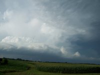
I started my day waking up at 5 am from my weather radios screaming at me for the incoming MCS. I got up, got ready, but couldn't find my camera (and still can't, mind you) and headed off just down the road from my house. I waited a little bit and caught an awesome shelf cloud as it came out of the north. Even on my crappy cell phone camera pictures, it still looks alright. 4864d00471bf65403b2340bf93e84a0b.jpg
6ffd3242602c43a870d15c17a3b89219.jpg
a6dd55db80d8650bb0b6e14502644087.jpg
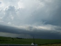
I then headed back home and got a little extra sleep before waking up at 11am to check conditions again. I had previously set a target of Princeton, IL while everyone was talking about going south of there towards Peoria or west of there towards the Quad Cities. Even with the thicker cap to the west I still left my house in Plainfield to sit and bake a few miles south of Princeton for about 3 hours before initiation. Once the storms started blowing up in Iowa I thought about heading over and crossing the river, thinking the outflow boundary had to of washed out by then. Right as I said that I got up and walked away from the laptop for a moment and noticed the towering cumulus that would become the Ottawa supercell just to my northeast. I went east across the river to avoid the jungles and hopped on 39 and headed towards Ottawa where I got a first glimpse of the first lowering from the bridge:1180fac8109ddd5af4d228c7ad8c2fa5.jpg
I went up 39 until it got to 80 and stopped at the first exit off of 80 for a moment to get a look at it a little bit better.914bb6879e983d8dcd5790ea0bb07293.jpg
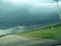
I went east on 80 again which turned out to be a mistake as the next exit wasn't for a few miles (I was chasing solo, @Brandon Molyneaux was trying his best to help me navigate while not even being in the car with me via the phone). I got off of 80 at the next exit and chased it through the windmill farms and fields southeast of Ottawa. It really tried a couple of times, but with not enough surface flow during the entire day, the RFD kept choking out anything it had. I have a really bad picture of what many people are calling a funnel cloud near Grand Ridge, it was rotating rapidly and pretty close to the ground but it's hard to distinguish from my picture and from where I was. But what you can see, is the very clear RFD notch wrapping around into it: 0eb2597c44a185fda6fbef656da396fb.jpg
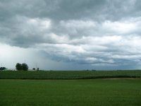
I got a few more OK shots off of my cell phone camera running down the Illinois grid dirt roads too. b3a70dd3b474fc85ee378d66783983ff.jpg
847e663fb3d07d67fd8c7c03b2226a14.jpg
This storm was full of "it coulda, woulda, shoulda" and it came pretty close, but since the inflow was so weak the RFD seemed to choke it out right before it would do anything. There where lots of funnel reports, but there was also a lot of fingerlike scud that looked like funnels. The only thing I could say may be a funnel that I saw was near Grand Ridge, and that's also where the greatest concentration of funnel reports came from. Still, it was an impressive display of RFD and clear slot structure that I'm glad I put some effort in to see. I chased it all the way until it hit I-55 near Dwight and then went back north to see if the storm near my home would have anything to offer, which it didn't. Overall I consider this a successful day for me as a noob to the chasing community, and a really good solo local chase for me. All things considered the morning MCS shelf cloud and the nice structure on the supercell really made the day for me, even if it didn't produce. I just wish I had a better camera at the time to get good pictures from.
 
I'll start by thanking my fellow Illinois chasers for their excellent reports above. My chase on this very hot and humid day was similar to theirs. I began by slowly moving north out of Peoria with the OFB from the morning's MCS. After reaching I-80, I headed east a bit, worried that I would end up stuck between the initial storm that fired far off to the west near Cedar Rapids, IA and the storm that was struggling against the cap to my east near Morris, IL. But as I waited a bit near Ladd, IL, the towering cu that would become the Ottawa supercell shot up just to my northwest. I took this first shot just south of I-80 near Ladd. The view is to the northwest:

IMG_4214.JPG

I then moved east on I-80 as the storm began to organize just to my north. I got off at the Utica, IL exit where the overpass provided a good view of the storm's base near the Love's truck stop. Here is one of the storm's early wall clouds from this vantage point. The view is to the northwest:

IMG_4246.JPG

I then headed east on County Road 33 for a few miles as the storm moved off to the southeast toward Ottawa. This photo, which looks southeast, shows the storm's growing precip core, RFD cut, and its scuddy underhangings as it moved over Ottawa:

IMG_4270.JPG

I then had to figure out the Illinois River crossing, which slowed me down. I ended up taking IL-23 south through town and eventually I had a good view of the storm was it moved out over the farms and wind turbines of rural La Salle county. Near Richards, IL I took County Road 5 east several miles and caught up with the storm, which now sported a very promising radar signature but seemed to be churning along in an area of almost no surface winds. It still managed to put on a good show, though. These last two pictures look northeast from near Ransom, IL:

IMG_4308.JPG

IMG_4312.JPG

I then took IL-17 east into Dwight, IL with everybody else. As the storm weakened off to the southeast of town, I called it a day and headed home.

It was great to chase a moderate-risk setup in Illinois again, and once again I was struck by the excellent road network that exists in this part of the state.
 
My day began with the morning MCS in Indiana. Observed the storm from a parking lot for about 30 minutes before it had passed and I was on my way to Illinois. Initially targeted Peoria due to the outflow boundary being near that location. Morning models was showing NE Illinois being a better target but I was skeptic and felt like the OFB was the best play. Got to Dwight and pulled over at a truck stop to check data. This is where I made my first mistake of the day as I decided to keep pushing toward Peoria even though the OFB was no longer present. Thinking was that initiation would begin around Davenport and I would be in a good position around Peoria to hop on that initiation. Had I stayed in Dwight I would have been in a perfect spot to target the Ottawa Supercell which turned out to be the best storm of the day. So I push forward to Peoria and I get frustrated to see that cells were forming where I was previously located. With no sign of any storm formation around Peoria, I went West on I74 and targeted the cell that had developed near Davenport. Intercepted this Supercell in the Kewanee area in Henry County. Noticed a very brief attempt to form a wall cloud but rotation never got organized. Gave up on this storm after it had exited Henry County and decided to head home. Was monitoring the storm that was north of I80 but after noticing what I believe to be a hail shaft I kept pushing on toward home.
 

Attachments

  • 018.JPG
    018.JPG
    153.3 KB · Views: 145
  • 023.JPG
    023.JPG
    139.3 KB · Views: 173
  • 026.JPG
    026.JPG
    178.4 KB · Views: 173
  • 056.JPG
    056.JPG
    203.3 KB · Views: 175
Initially I was targeting NW of Peoria for the development coming in from Iowa in the hope of surfing it home but decided to shoot east for the NE storm everyone was on as the western activity ended up looking messy. Arriving late to the former Ottawa storm from just north of Pontiac near Odell, I also spent time in the wind farms. Afterwards, I paused for sunset from north of El Paso under the downstream anvil of a new severe somewhere in the vicinity of Princeton. This experience alone made the overall effort worthwhile.

IMG_6821a.jpg

IMG_6829a.jpg

IMG_6833a.jpg

IMG_6837a.jpg

IMG_6859a.jpg

IMG_6872a.jpg

 
My first time chasing in Illinois believe it or not. Same story as most people in here. We briefly got on the storm southwest of Joliet before bailing west on the one near Ottawa. We were greeted with some amazing structure south of Ottawa with a very nice spinning updraft.

57a878d8e3cdc0e6ab4cd531f52cc367.jpg

The low levels just couldn't get the job done. But the RFD cut was so cool to see slicing the base each time. Made for some great viewing especially from the west side of the storm.

505513d37fbc1d8139e9c3af2ce1ca8d.jpg

We followed the storm to near Kankakee where the sunset really painted the skies with some very rich saturated colors. I didn't have to even touch anything with the colors on these pics. Just some noise reduction and brightness.

890e3a6c8f73f9199bbf030c686f6043.jpg

On our way back to Chicago for the night up I-57, I had almost no time to avoid an entire semi tire retread carcass in my lane. I hit it hard and it tore my bumper up pretty good.

9c182b9c615395e37fe55d11be725a4e.jpg
 
Back
Top