Dan Robinson
EF5
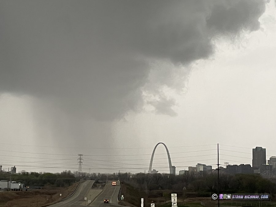
Day 2 of this Midwest severe weather sequence would see supercell and tornado potential once again present in the St. Louis metro, and again would preclude any idea of me traveling outside of the area for storms. The chase day started early for me. At 7AM, I got on the road headed west for a line of morning storms approaching the city. I originally planned to do the normal thing of catching the leading cores in the city, then setting up to shoot upward lightning in the trailing stratiform region.
But as I got to within 10 miles of downtown, tornado warnings started firing off for QLCS circulations in the line just north of the metro area. I briefly entertained diverting north to intercept them, but feared that I'd be cutting it too close to be able to beat them to their I-55 crossing points. I also figured they might dissipate by then anyway as QLCS circulations often do. So, I chose to let the QLCS action go and continue to downtown.
The leading cores were uneventful, with no lightning and not much of any structure to be seen.
I didn't stay downtown, going immediately to set up in Brentwood for upward lightning. There was absolutely no lightning in the trailing stratiform region. After 30 minutes without seeing a single flash, I headed back home.
I spent the rest of the morning and early afternoon finishing up the hail shield build (see that post in the Equipment section of ST) while simultaneously keeping track of how the main severe weather event evolved. The morning squall line would be producing an outflow boundary that was forecasted to stall to our south, then slowly lift back north potentially into the metro area by late afternoon storm time. This would be the most favorable location for tornadoes. However, models also indicated numerous supercells firing areawide.
By midafternoon, cumulus was building up on the outflow boundary situated roughly from Festus to Red Bud, and soon, storms began to fire just southwest of there. So, I headed out, going down the same roads I'd just taken the day before to get to Ruma. The lead storm crossing the river and heading for Red Bud quickly went supercellular and looked like an obvious target. But now there was a new complication.
A storm that had fired earlier near Columbia, Missouri had evolved into a very healthy and classic-on-radar supercell and was turning hard right just south of I-70 west of Wentzville. It looked like it could potentially go right through the heart of the St. Louis metro area. Surface winds in the immediate metro were weak and badly veered (southwest) so it looked very much like that storm would have difficulty producing a tornado. The outflow boundary supercell looked much healthier and should be much more favored for tornadoes, but it seemed to be having issues with parasitic storms on its southwest flank. Do I go back for the low-tornado-threat St. Louis metro storm, or stay along the outflow boundary for a much higher tornado risk? I stopped at Freeburg for a full 20 minutes debating this decision.
After watching the St. Louis supercell seem to struggle on reflectivity and have very weak to nonexistent couplets on velocity - followed by new storms going up just ahead of it that would interfere with its inflow (not favorably positioned for merger-enhanced intensification), I made the final choice of staying with the outflow boundary storm. I arrived on the Red Bud storm to find some dramatic structure - probably the best I've seen locally.
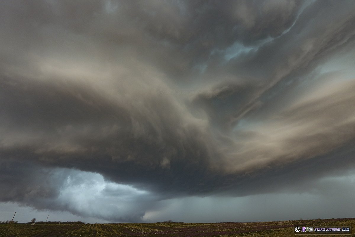
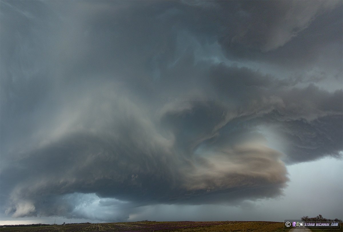
A strong RFD was surging in, but the main meso (on the north side of the RFD horseshoe) was disorganized with very little in the way of lowerings or visible rotation. An old meso to the west appeared much more active, so I drove west to take a look. Low-level motion was weak with this feature, though, so I abandoned this and decided to get back ahead to see if the next cycles would be more fruitful.
I had considerable difficulty getting back ahead of the storm, as it was moving northeast at a good clip, at least 45mph. Structure was dramatic as I made my move east and north, with frequent tall positive CG lightning in the vault region. I caught up to a new meso briefly north of Marissa, but almost immediately was overtaken with heavy precip before I could get a good look at it. I struggled to get ahead of the storm, going all the way to Nashville before finally getting out of the rain! By this time, the storm had weakened considerably with the trailing storm to the southwest looking like the next player. So, I continued east to Ashley, preparing to drop south to intercept.
As soon as I made the turn south on Highway 51 east of Ashley, the next radar update showed that storm weakening also. Meanwhile, back in St. Louis, numerous new storms had gone up and a stratiform region was approaching the metro from the southwest. I decided to just call the supercell/tornado chase and go back into the city for upward lightning. On the return trip on I-64, I passed through another marginal supercell (elevated with no tornado potential) at Okawville.
I arrived at my Brentwood location for upward lightning with the last light of the post-sunset sky peeking through the back edge of the cloud deck to the west. The stratiform region was directly overhead now, but there was no lightning propagating through it - all lightning was confined to the cores to the distant south and east. Notwithstanding, I kept shooting until the stratiform region was completely east of the area (I know better than to turn my back on such a situation!). I packed up and headed home, ending the chase day at 9PM.
But as I got to within 10 miles of downtown, tornado warnings started firing off for QLCS circulations in the line just north of the metro area. I briefly entertained diverting north to intercept them, but feared that I'd be cutting it too close to be able to beat them to their I-55 crossing points. I also figured they might dissipate by then anyway as QLCS circulations often do. So, I chose to let the QLCS action go and continue to downtown.
The leading cores were uneventful, with no lightning and not much of any structure to be seen.
I didn't stay downtown, going immediately to set up in Brentwood for upward lightning. There was absolutely no lightning in the trailing stratiform region. After 30 minutes without seeing a single flash, I headed back home.
I spent the rest of the morning and early afternoon finishing up the hail shield build (see that post in the Equipment section of ST) while simultaneously keeping track of how the main severe weather event evolved. The morning squall line would be producing an outflow boundary that was forecasted to stall to our south, then slowly lift back north potentially into the metro area by late afternoon storm time. This would be the most favorable location for tornadoes. However, models also indicated numerous supercells firing areawide.
By midafternoon, cumulus was building up on the outflow boundary situated roughly from Festus to Red Bud, and soon, storms began to fire just southwest of there. So, I headed out, going down the same roads I'd just taken the day before to get to Ruma. The lead storm crossing the river and heading for Red Bud quickly went supercellular and looked like an obvious target. But now there was a new complication.
A storm that had fired earlier near Columbia, Missouri had evolved into a very healthy and classic-on-radar supercell and was turning hard right just south of I-70 west of Wentzville. It looked like it could potentially go right through the heart of the St. Louis metro area. Surface winds in the immediate metro were weak and badly veered (southwest) so it looked very much like that storm would have difficulty producing a tornado. The outflow boundary supercell looked much healthier and should be much more favored for tornadoes, but it seemed to be having issues with parasitic storms on its southwest flank. Do I go back for the low-tornado-threat St. Louis metro storm, or stay along the outflow boundary for a much higher tornado risk? I stopped at Freeburg for a full 20 minutes debating this decision.
After watching the St. Louis supercell seem to struggle on reflectivity and have very weak to nonexistent couplets on velocity - followed by new storms going up just ahead of it that would interfere with its inflow (not favorably positioned for merger-enhanced intensification), I made the final choice of staying with the outflow boundary storm. I arrived on the Red Bud storm to find some dramatic structure - probably the best I've seen locally.
A strong RFD was surging in, but the main meso (on the north side of the RFD horseshoe) was disorganized with very little in the way of lowerings or visible rotation. An old meso to the west appeared much more active, so I drove west to take a look. Low-level motion was weak with this feature, though, so I abandoned this and decided to get back ahead to see if the next cycles would be more fruitful.
I had considerable difficulty getting back ahead of the storm, as it was moving northeast at a good clip, at least 45mph. Structure was dramatic as I made my move east and north, with frequent tall positive CG lightning in the vault region. I caught up to a new meso briefly north of Marissa, but almost immediately was overtaken with heavy precip before I could get a good look at it. I struggled to get ahead of the storm, going all the way to Nashville before finally getting out of the rain! By this time, the storm had weakened considerably with the trailing storm to the southwest looking like the next player. So, I continued east to Ashley, preparing to drop south to intercept.
As soon as I made the turn south on Highway 51 east of Ashley, the next radar update showed that storm weakening also. Meanwhile, back in St. Louis, numerous new storms had gone up and a stratiform region was approaching the metro from the southwest. I decided to just call the supercell/tornado chase and go back into the city for upward lightning. On the return trip on I-64, I passed through another marginal supercell (elevated with no tornado potential) at Okawville.
I arrived at my Brentwood location for upward lightning with the last light of the post-sunset sky peeking through the back edge of the cloud deck to the west. The stratiform region was directly overhead now, but there was no lightning propagating through it - all lightning was confined to the cores to the distant south and east. Notwithstanding, I kept shooting until the stratiform region was completely east of the area (I know better than to turn my back on such a situation!). I packed up and headed home, ending the chase day at 9PM.