adlyons
EF2
A potential regional severe weather event looks to unfold in the day 3 time frame for the Great lakes region. SPC currently has a D3 ENH risk for much of the area outlined.

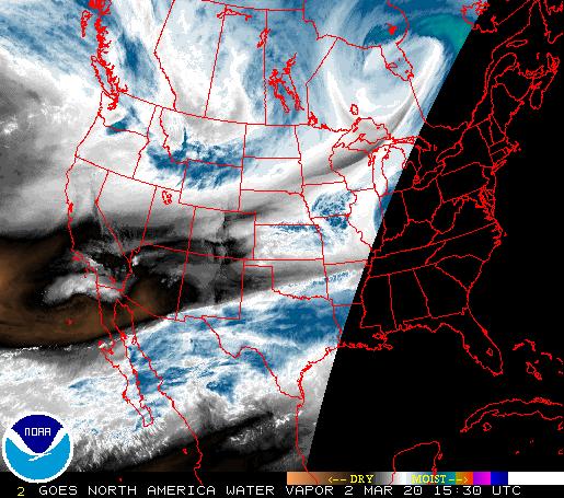
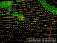
Taking a look at observations as of 244CDT Regional Soundings indicate deep moisture is pooled across the OH/MS river valleys. ILX has PWAT near near 1.5 in
 Same story from ILN with PWAT 1.5 in and dews in the midd to upper 60's/ low 70s
To the north, PWAT is much lower and temps are cooler. A weak front lies in the area.
Same story from ILN with PWAT 1.5 in and dews in the midd to upper 60's/ low 70s
To the north, PWAT is much lower and temps are cooler. A weak front lies in the area.
 The feature will gradually shift south over the next few days as the remnants of Bill exit to the east. On 6/21 SUN the boundary begins to lift north as a warm front ahead of the next upper wave.WV imagery currently shows the wave near the PAC NW coast coming on shore over the next 12 hours.
 This wave is also expected to be a player for the previous day 6/21. * See thread on 2015-06-21 EVENT: IA,NE,KS,MO* for updates on that event. As the wave digs over the next few days it should light off quite a few storms. Expect MCS to be ongoing from previous day which should lay down a few OFBS to play with during the day. I also expect the lake breeze to be a potential player.
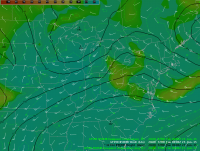
Diving into model land I like what I see. *Excuse the AWIPS images I'm at work and using some custom color tables. They may not be the best. Still messing with them to get them right.* First up is ECMWF 500 heights and ABS Vorticity Image shows a shortwave trough with smaller disturbances in an area of enhanced flow near and west of the Great Lakes. Main concern is the area immeadiately east of the main shortwave in WI and Mi. Strong shear is going to be present here wich could really get things going if instability is high. A couple smaller disturbances are even visible down near IL IN MI and western OH. Here shear is slightly weaker, but Instability should be more than ample to compensate.
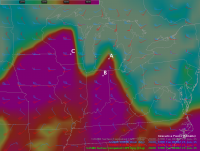
Looking slightly lower at GFS 850 mb we see a strong low level jet response due to the strengthening surface low over WI. 35-55 knots would mean a serious amount of low level shear in play fro almost the entire area. ECMWF is a touch weaker but still has a large area of 35-45 knots at 850 which is contributing to 0-6km shear upwards of 50 knots. Looking ahead at the thermodynamic environment, the NAM 80km has cape greater than 5000 for the entire southern target area and 3500-4500 values for the northern target which seems a little high. This should be more than ample for sig severe. One thing to note is the lake breeze signal showing up in northern Indiana. SPC only has this area in Marginal risk currently. However, with 6km shear at 50 knots oriented perpendicular to the lake breeze and strong instability plus direction shear present, I would expect isolated discrete storms in this area. There is even a slight possibility of a few storms in the warm sector near the warm front over northwestern Ohio by peak heating. Shear is slightly weaker in theses areas, but strong turning suggest a tornado threat is possible. *See sounding B* Looking at the soundings, WI shows very strong instability, strong shear and good turning. Expecting a good chance of TORs possibly strong/sig as well as enhanced wind damage and very large hail. .

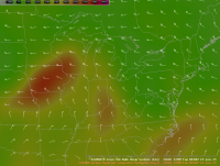
Sounding B which is Northern Indiana Western Ohio shows Moderate shear and very strong CAPE. Here I would expect Isolated storms with again all SVR modes possible with an emphasis on hail and wind though I cant rule out an isolated strong tor here.

Sounding A which is Lower Michigan shows very similar traits to Sounding B but with stronger flow aloft and slightly weaker cape. Very strong turning is present with very high helicity values. Expect all svr possible again with signals indicating chances for tornadoes possibly strong/sig.

A lot needs to be watched here as this could be a boom day. However model spreads are fairly high. ECMWF is lower with cape but still strong on the shear side. Lets get some discussion going. If you want chaser opinions, Northern Indiana and NW Ohio are pretty great in the chase terrain department aside from trees.
Taking a look at observations as of 244CDT Regional Soundings indicate deep moisture is pooled across the OH/MS river valleys. ILX has PWAT near near 1.5 in
Diving into model land I like what I see. *Excuse the AWIPS images I'm at work and using some custom color tables. They may not be the best. Still messing with them to get them right.* First up is ECMWF 500 heights and ABS Vorticity Image shows a shortwave trough with smaller disturbances in an area of enhanced flow near and west of the Great Lakes. Main concern is the area immeadiately east of the main shortwave in WI and Mi. Strong shear is going to be present here wich could really get things going if instability is high. A couple smaller disturbances are even visible down near IL IN MI and western OH. Here shear is slightly weaker, but Instability should be more than ample to compensate.
Looking slightly lower at GFS 850 mb we see a strong low level jet response due to the strengthening surface low over WI. 35-55 knots would mean a serious amount of low level shear in play fro almost the entire area. ECMWF is a touch weaker but still has a large area of 35-45 knots at 850 which is contributing to 0-6km shear upwards of 50 knots. Looking ahead at the thermodynamic environment, the NAM 80km has cape greater than 5000 for the entire southern target area and 3500-4500 values for the northern target which seems a little high. This should be more than ample for sig severe. One thing to note is the lake breeze signal showing up in northern Indiana. SPC only has this area in Marginal risk currently. However, with 6km shear at 50 knots oriented perpendicular to the lake breeze and strong instability plus direction shear present, I would expect isolated discrete storms in this area. There is even a slight possibility of a few storms in the warm sector near the warm front over northwestern Ohio by peak heating. Shear is slightly weaker in theses areas, but strong turning suggest a tornado threat is possible. *See sounding B* Looking at the soundings, WI shows very strong instability, strong shear and good turning. Expecting a good chance of TORs possibly strong/sig as well as enhanced wind damage and very large hail. .
Sounding B which is Northern Indiana Western Ohio shows Moderate shear and very strong CAPE. Here I would expect Isolated storms with again all SVR modes possible with an emphasis on hail and wind though I cant rule out an isolated strong tor here.
Sounding A which is Lower Michigan shows very similar traits to Sounding B but with stronger flow aloft and slightly weaker cape. Very strong turning is present with very high helicity values. Expect all svr possible again with signals indicating chances for tornadoes possibly strong/sig.
A lot needs to be watched here as this could be a boom day. However model spreads are fairly high. ECMWF is lower with cape but still strong on the shear side. Lets get some discussion going. If you want chaser opinions, Northern Indiana and NW Ohio are pretty great in the chase terrain department aside from trees.
Attachments


Last edited:


") Now that we're in the range of other models (I like Canada) and they also are on board, I'm less concerned than yesterday. I do find it interested that the CIPS still flags 05/31 as the top analog! I don't like the format some broadcast mets use where they actually mention that date publicly, as I'm not sure that's what the intention is of those analogs, but nonetheless it catches my eye!
Now that we're in the range of other models (I like Canada) and they also are on board, I'm less concerned than yesterday. I do find it interested that the CIPS still flags 05/31 as the top analog! I don't like the format some broadcast mets use where they actually mention that date publicly, as I'm not sure that's what the intention is of those analogs, but nonetheless it catches my eye!


