• While Stormtrack has discontinued its hosting of SpotterNetwork support on the forums, keep in mind that support for SpotterNetwork issues is available by emailing [email protected].

2015-05-19 EVENT: TX, NM, OK, CO

Joined
Oct 2, 2006
Messages
227
Location
Montréal, Qc, Canada
Seems like Tuesday should be a chase day in the Panhandle region.

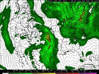
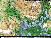
With 50 kts deep layer shear and the possibility of good instability (early convection could ruin this one) things sure look interesting.

While best low level shear appears to be North of the instability axis, if a storm can make it to the Eastern part of the Panhandle where stronger H8 winds are present, we could be in for some 'Panhandle Magic'.


I see two possible targets, the first one could be in the vicinity of the OK/NM/CO border where a small window might exist. I like the better winds @ 250mb over there and the position compared to the H5 jet streak seems more optimal. However, destabilization for this Northern target is questionable for now and choosing this target could be based on whether or not we accept marginal CAPE for more optimal dynamics.

Second target would be somewhere between Lubbock and Amarillo, from the NM border. Better instability but low level shear is marginal at best. May try to watch for some differential heating boundary from morning crapvection or for any storm moving NE into the 30kts 850 mb wind axis along highway 287 between Childress and Amarillo. Should storm initiate closer to the NM border where the GFS solution seems to place the dryline we could be in for a patience game.
 
I will post this in the EVENT thread since I was not actively chasing. As I was passing through the Mancos, CO area this afternoon, I noticed what appeared to be a funnel cloud a little after 2:40 p.m. At first I thought just a look-alike, but as I watched it for a few minutes, I realized it really was a funnel cloud. It persisted for 8-10 minutes. It was likely a little NW of Mesa Verde and northeast of Cortez. I debated calling it in, but it was never more than a quarter of the way down, and about the time I thought maybe I should, it began to dissipate. However, a local spotter did report it and the Grand Junction NWS office did put out a tornado warning on it. Here are a couple pictures:

IMG_0241-eml.jpg IMG_0244-cr-eml.jpg
 
Although I was actively chasing today, I am posting this in the Event thread because it is primarily a question. I was playing the dryline west of LBB, and after some promising Cu development the area later seemed to dry out. I went after the only storm that was within range, near Lamesa, but despite having an LPish base for a time it just never got its act together and reached only about 35,000 feet up. It shriveled up and died the moment I reached it, and never attained warning criteria.

So my question is, what suppressed storm development between the Fort Stockton tornadic storm and the junk on the boundary up near AMA? I looked at 0Z model analysis and when I saw the veered 850 winds (see attached image) I thought that was the answer, but then a look at 850 Td's (also attached) seemed to indicate that, despite 850 winds being southwesterly, there wasn't much drying taking place, so what happened??
 

Attachments

  • ImageUploadedByTapatalkHD1432093037.191150.jpg
    ImageUploadedByTapatalkHD1432093037.191150.jpg
    317.1 KB · Views: 152
  • ImageUploadedByTapatalkHD1432093055.313735.jpg
    ImageUploadedByTapatalkHD1432093055.313735.jpg
    329.7 KB · Views: 156
James I think your first impression is right. Despite being moist enough, low level winds were not backed. Surface and 925 mb were not backed much either. Outflow boundary enjoyed locally backed low level winds and produced. Same scenario may unfold this weekend. Good luck if you're still going to be out there.

John sweet pictures up in Colorado! Interesting I once saw a Colorado tornado not trying. On the way back from skiing, yup a little early, Denver Cyclone magic brought a rope.
 
James I imagine the early precip took its toll once again. Mesoanalysis showed weak mid level lapse rates, which really hindered any rapid development. The only reason the storms near Amarillo (which is what I chased) came close to doing anything was because of the presence of several outflow boundaries, which helped pool more moisture at the surface. It was clear to me in the morning that NW TX was the place to be all day, but couldn't get out of work in time to go. It had the moisture and bulk shear to work with, as well as several boundaries.
 
Thanks Jeff and Marcus.

Marcus, you're right of course about NW TX, but I never really considered that region, I was always intent on playing the dryline. I don't like those scenarios where rather than pristine initiation you have to depend on ongoing morning convection to intensify or new development to occur along the southern or eastern edge of the ongoing storms... I just don't find those scenarios to be very chaseable but maybe that's to my detriment (obviously it was yesterday...)
 
Our morning initial target was Childress with plan to decide between NW Tx and I-27 corridor once skies clear up a little. We ended up taking the wrong choice, mainly because we didn't like the storm mode already ongoing in NW Texas at first, and clearer skies to the West gave us some hopes for discrete development along the dryline.

Still got two HP supercells with some rotation but nothing ever came close to producing since storms were rapidly undercut by cold air from outflow originating from first storm that tracked South of AMA. Also both storms tracked into difficult to chase territory with few paved roads to chase. We tried one dirt road and rapidly found out after 100 ft that this was not even remotely an option: took 20 minutes to get back on the main road from these 100 ft and I really thought we would have to call for help to get the car out. Now I know why I miss real 4 X 4 vs AWD.

Hopefully will make better decisions later in our chasecations.
 
Actually I am questioning my own theory about the veered 850 winds hurting storm development in the LBB area, as they were also veered in the Fort Stockton area where there was an isolated tornadic supercell. Any thoughts on the difference between the two regions? Anyone catch the FST storm?

Jim
 
I didn't look at any data out there as I was busy chasing farther east, but don't forget that because of elevation on the Caprock and points west, the surface is actually around 900 - 880 mb out there. So 850 mb winds are only 30-50 mb above the surface. You might want to see if anything was happening at 700 mb, for instance.
 
Back
Top