2015-05-16 EVENT: TX, OK, KS, NE, SD, IA, MO,MN

Well i just woke up to the sun shining through my window. I quick glimpse at Vis and Radar doesn't show much is the way of a big organized system to work over the Atmos this morning. The storms seem to be getting more diffuse as the work toward the I-35 corridor, similar to what the models were suggesting last night.

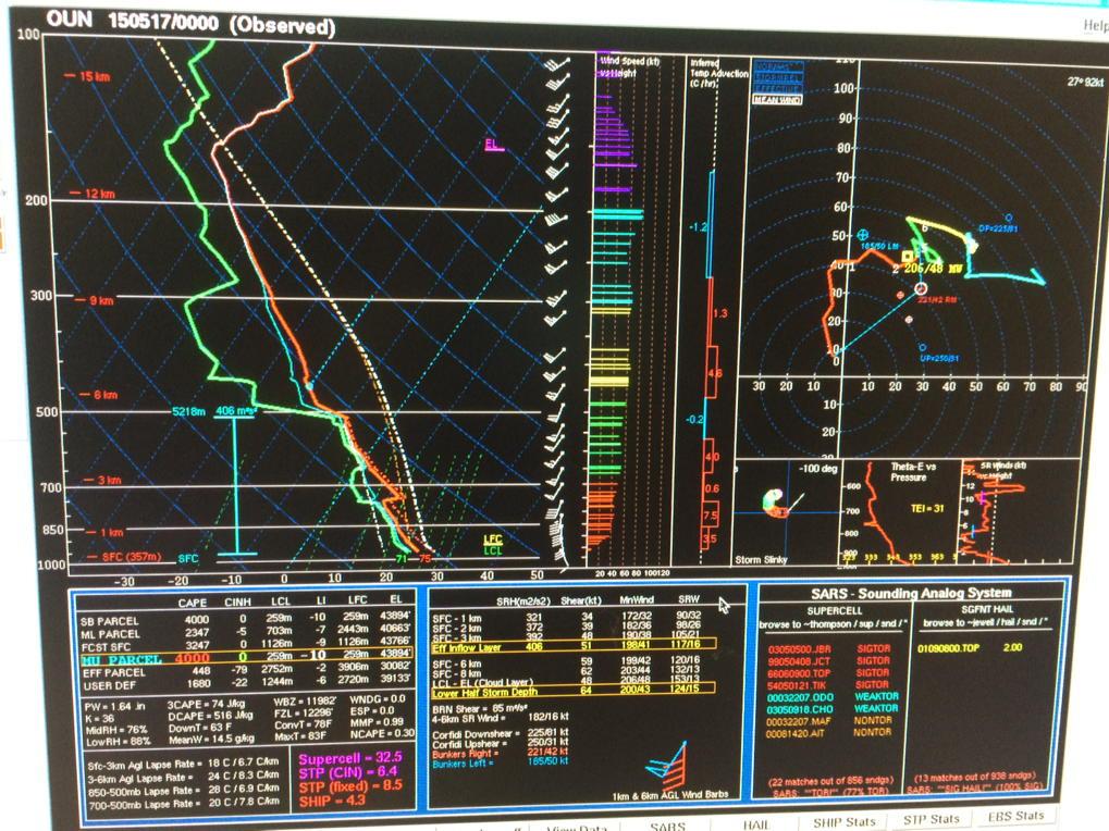
So, I would say get ready and see what the 12z gives us. Could be an active day. 2000+ SBCAPE in 12z OUN Sounding.

Just thought I would throw this out there... Here is a quick look at the HRRR showing a STP of 15 west of OKC at 01z.
hrrrOKC_con_stp_014.gif
 
Last edited:
Somebody please tell me that everything I ever learned about forecasting is wrong.

For one thing, the lid strength is gone by 18Z, per RAP and NAM, so. Then, the hodos stink. Where are the curves? It all looks pretty straight-line with the exception of right around extreme W & SW OK, and there's ongoing crapvection west of there as I type. Just look at forecast EHI's for confirmation of this.

I'm sure I'll be proven hideously wrong, like I often am, but I'm really scratching my head as to how we're going to get anything but a gigantic MCS from ND to TX.
 
The HRRR does seem to be handling the morning precip a little better today than it did last week. Still under-doing the amount of convection in the TX Panhandle, so I'm not entirely sold on it going bonkers later today. Last night's MPAS run also missed the convection in the TX Panhandle, so it's probably also unreliable.
 
Current observations show backing surface winds across N TX and much of OK. If we see this later on to any notable degree, tornado potential with any supercells is going to go up in a hurry.
 
Somebody please tell me that everything I ever learned about forecasting is wrong.

For one thing, the lid strength is gone by 18Z, per RAP and NAM, so. Then, the hodos stink. Where are the curves? It all looks pretty straight-line with the exception of right around extreme W & SW OK, and there's ongoing crapvection west of there as I type. Just look at forecast EHI's for confirmation of this.

I'm sure I'll be proven hideously wrong, like I often am, but I'm really scratching my head as to how we're going to get anything but a gigantic MCS from ND to TX.

I have to agree.

However, the ruc suggests the E/NE TX panhandle will offer a target in the 18-21z hours with no substantial DL push and favorable instability due to recovery. I also think numerous outflow boundaries will only enhance shear. I'm guessing the 16:30z outlook will move the mod. towards the west / nw.

This is also supported by the 13z HRRR that shows isolated cells in the same time frame.

Initial target will be Dumas, TX -- to be adjusted.
 
In infer from the SPC 13Z that they actually considered down to ENH but I am glad they kept MDT. Tornadoes will verify today, but perhaps not all up and down the DL. Hodos are not great. However where OFBs can enhance local low level shear, total hodos will indeed promote tornadoes - some maybe strong only along OFBs.

I infer SPC are concerned about uncertainty, thinking about ENH, but the synoptic pattern requires MDT. Any English majors in the house? I don't have a dog in the hunt. Reluctantly elected to sit out this one. My optimism along OFBs is not wish-casting, but based on my understanding of the meteorology. Good luck to everyone; and, with the messy mode and crowds, please chase extra safely today.

UNCERTAINTY IN THE SUBSEQUENT EVOLUTION OF THIS EARLY CONVECTION AND
DEGREE OF AIR MASS RECOVERY IN ITS WAKE DURING THE LATE
MORNING/AFTERNOON...AND HOW THIS EVOLVES WILL IMPACT LOCATIONS AND
LIKELIHOOD OF SEVERE STORMS THIS AFTERNOON AND EVENING. GIVEN THE
FAVORABLE SYNOPTIC PATTERN...HAVE OPTED TO MAKE LIMITED ADJUSTMENTS
TO THE OUTLOOK AREAS WITH THE EXPECTATION THAT THE MESOSCALE
SCENARIO WILL BECOME MORE EVIDENT AS THE DAY PROGRESSES.
 
Last edited:
Keep in mind that hodographs don't have to be nicely curved to get tornadoes. Check out the OUN soundings for May 6th. The 19Z sounding in particular looked pretty ugly in the 1-6 km layer, but nearly 30 kts of 0-1 km shear helped make it quite the tornado day for the area. Also keep in mind that LCLs and LFCs were pretty low that day, just like they are in the 12Z OUN sounding. The S-shaped hodographs tends to lead to messy or transient supercell structure, but that doesn't preclude storms producing tornadoes.

This might very well be a day filled with tornadoes lacking decent supercell structure aloft.
 
Edit: OUN launching 18z sounding

Per OUN emergency management briefing
New Moderate risk will likely look like this.

image8.jpg


Last edited:
I've been staring at models all morning and Nebraska is really up in the air. We've got morning blow-off covering SC Neb, but Omaha and Lincoln are almost at 80 already with almost 70 DP's. I really want to go chase the stuff that will form on this outflow from KS right now...but I know shear isn't here yet. 6pm to 10pm Tonight from Beatrice to Omaha high res models are still showing 3-4k Cape with 0-1KM SRH hitting almost 300. I'm expecting some sort of MCS to be pushing in from the west, but anything that forms on outflows or can get ahead of the line will be nasty. The Hallum, NE 2.5 Mile Wide Monster was a rogue cell out ahead of the main squall on a similar day. Cell produced for nearly 4 hours before picking up just south of Lincoln around 10pm. Where is Reed Timmer when I need him?

My Target today: Beatrice, NE around 5pm moving back to Omaha at Dark.
 
I-44 corridor is where it's at today. DPs in the 70s and clouds are clearing. In Joplin now. Taking I-44 southwest until storms start initiating. Then I'll head west to intercept.
 
Question, is this model an experimental mid-range derivative of the NAM combined with the hourly forecast projection of the HRRR?

@Russ Conlon, MPAS is a next-gen global model, it's not derivative of any existing model. It's a hexagonal grid, which allows it two major advantages over existing models:

1. It has no "pole problem" of messy singularities at the north or south pole that must be dealt with in ugly ways
2. It can have a continuously variable resolution across the globe unlike WRF-based models (NAM, HRRR), so that you don't get boundary-related issues as seen in those models

This presentation has a lot of details, including graphical examples of the variable mesh in action: http://www2.mmm.ucar.edu/people/skamarock/Presentations/AMWG_2013_skamarock.pdf
 
good line of storms beginning to fire east of Lubbock on into the pandle of TX, and moving NE towards SW OK. Positioning my crew (J.J. Tomash and John Reed) and I in Clinton,OK here shortly to stop for food and to re-assess the situation. A bit hesitant to move any further east just yet, but should still be in a good position to move E or SE to intercept if necessary, but we wont be out of position to backtrack to the west if we have to.
 
Back
Top