Lanny Dean
EF5
EDIT - PLEASE NOTE that I had issues trying to post images/URL links.
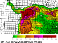
Appears that a significant severe weather event is shaping up from mid week to late week as a multiday event possibly starting as early as Tuesday. Of real interest seems to be the Wednesday/Thursday timeframe as of right now. Latest model guidance (GFS and Euro) have been very consistent during the last 84 hours from run to run and indicates a more traditional spring setup - powerful mid and upper trough swinging out into the plains area
As it stand right now, it would appear that Wednesday *may* have the "better" dynamics (shear- direction and speed, introduction of the trough, 45kt southwest push at H7 with temps nearing 7-10 degrees C, 30kts+ southerly at H85, and 20-25kts at the basement) 850-500mb cross over simulation is not quiet as interesting. However, strong instability on both models look interesting: Simulated ML CAPE values up the I-35 corridor (Salina,KS to OKC) in excess of 3000j/kg with LI's -9 to -11. Lifted Condensation Levels through this area are more than doable with simulations of 750m or less as well.
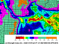
The only caveat that might be realized for Wednesday is the quality of moisture return. GFS is currently painting 65* dews with a very sharp surface dryline extending from far northern KS to TX. Concerns for the depth and quality of moisture may play a role, as may the CAP if temps near H7 increase above current advertised. But experience tells me that this could be the "day before the day" with isolated supercells producing all modes severe. Appears that a DL retreat will aid in setting the stage for Thursday
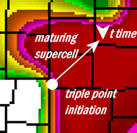
Of more interest, at least on a broader scale, is Thursday. Model consensus in pushing the DL further east as the trough ejects and taking a true negative tilt. The tilt *may* lessen the tornado potential as depicted with current GFS solution but increase the overall severe potential. 18z and 0z showed classic forcing but admittedly the 0z run 850-500 looks like the low is stacking to some degree. This can be seen in the simulated hodos from ICT east towards Pittsburg, Kansas. Latest Skew-t was more impressive as well and if verified we *could* be looking at a significant severe/tornado outbreak.


