• A friendly and periodic reminder of the rules we use for fostering high SNR and quality conversation and interaction at Stormtrack: Forum rules

    P.S. - Nothing specific happened to prompt this message! No one is in trouble, there are no flame wars in effect, nor any inappropriate conversation ongoing. This is being posted sitewide as a casual refresher.

2013-05-20 Reports: OK/KS/MO/TX

Joined
Aug 15, 2005
Messages
115
Location
Norman, OK
Witnessed Norman/Moore tornado from touchdown to crossing I-35.

ry4eryna.jpg


Joshua T. Clark

Was at Indian Hills and 36th NW. My son's daycare is there.
 

Attachments

  • ImageUploadedByTapatalk1369088217.626119.jpg
    ImageUploadedByTapatalk1369088217.626119.jpg
    11.6 KB · Views: 309
  • ImageUploadedByTapatalk1369088231.241518.jpg
    ImageUploadedByTapatalk1369088231.241518.jpg
    13.4 KB · Views: 286
  • ImageUploadedByTapatalk1369088247.691755.jpg
    ImageUploadedByTapatalk1369088247.691755.jpg
    13.7 KB · Views: 350
  • ImageUploadedByTapatalk1369088257.276148.jpg
    ImageUploadedByTapatalk1369088257.276148.jpg
    17.8 KB · Views: 285
  • ImageUploadedByTapatalk1369088267.790894.jpg
    ImageUploadedByTapatalk1369088267.790894.jpg
    8.6 KB · Views: 339
Last edited by a moderator:
I got a late start to the day, as I had to work until about 2pm. I immediately hit I35 South, to I40...then Anderson Rd. South to avoid the hail. I went back West on SE 149th I believe. Went North on Sooner Rd. a half mile or a mile, I really cant remember. But, I caught the grinder coming out of the rain core, straight at my position. (Same position I believe as Ben Holcomb :cool: ) and had to drop South...this is what I witnessed...

Watch video >

Here are a couple of stills, that I shot from the position I had to abandon...
8758960351_c4d3082689_o.jpg

8758960489_f536066a4b_o.jpg


I cannot describe the feeling of watching this play out in front of my eyes...I'll never forget it...
 
Just a devastating day for all and a chase that was made much less enjoyable by the pictures and news coming out of Moore this evening. We saw the radar signature and debris ball as it formed roughly 40 miles to our north (we targeted W of Pauls Valley) and instantly knew that the situation in Moore was dire. My thoughts go out to all of those affected today, I know a lot of chasers have friends and family (as well as homes) in the area. I won't bother with pictures from our junk to the south but I can say that I am humbled and a lot less excited about the next chase opportunity after witnessing the disaster that has unfolded today. I made it home this evening and gave my little girl a kiss but it breaks my heart to know that there are parents in Moore who won't get that opportunity.
 
We chased southern ok and north tx today. I'm not even gonna go into our chase account. I cant think about anything but Moore. I'm accompanying my 3rd grade daughter on a field trip tomorrow along with 30 of her schoolmates. I cant think of anything but those kids trapped and that they are the same age as my little Hannah. Kiss your kids and hold them close guys.....
 
Well said Brandon and Jeremy. I feel the same way and pray for all affected in Moore. I cannot imagine being a parent facing the fear and uncertainty of a missing child tonight. The Moore tragedy overshadows and supplants the typical process of making sense of the chase day. We targeted southwest OK toward Wichita Falls and went after one of the first storms that went up, eventually getting inside the notch near Bray to see the updraft, which looked good for a bit, before becoming completely rain-wrapped as it moved off to the northeast. We were aware of the OKC area storm but never seriously considered going after it because it was out of our target area. we didn't pay too much attention to it and didn't look at it too closely so had no idea there was anything unusual about this particular tor-warned cell... Ironically, I first learned of the tragedy from a buddy back home on the east coast.

We left the Bray storm and futilely tried to get to the more southern storms in north TX but everything was a rain-wrapped HP mess.

While it goes without saying that I am saddened by the Moore tragedy, I would also like to understand why and how that monster was created in that particular area, which did not seem to be a particularly favored area for development. I am interested in hearing analysis from those who chose that target area or can explain in hindsight why this happened in that particular place.


Sent from my iPad using Tapatalk HD
 
First off, my heart goes out to all that were directly and indirectly affected by the Moore tornado. This devastating tornado just hit at a bad time in a large city. I hope to never witness such a monster in a similar environment. With that said, I'm not looking for likes or anything on my pics, just posting them here to reflect what I saw.

I chased with my girlfriend, Hannah Taylor, James Siler, and Brady Kendrick. We went south near Lindsey to intercept that cell. After watching our storm begin to die off, and the storm up north begin to hook, we broke off and drove north. Fighting the slow traffic we eventually came north on SE 24th Ave east of Norman. We caught sight of the tornado to our NW at 24th Ave and 164th St. We saw the tornado as a large barrel before it roped out.

Moore%20tor-X2.jpg


We kept pace with the storm up north of I-40 and we saw the right edge of another large possibly a wedge tornado north of Meeker. We lost sight of it in the hills and trees. We were between Meeker and Prague when what looked like a satellite tornado came down to our northeast and wrapped itself into the main core/possibly rain wrapped tornado.

Prague%20tor-L.jpg
 
My friend and I drove all they way across Illinois and approached the Mississippi River just as the tornado warning was issued for Hannibal, MO on the other side. I chickened out and didn't think we could cross and get out of Hannibal in time to view the approaching storm, so we ended up with nothing, as the whole area turned in to a typical Illinois HP squall line mess. It was a long drive home and I was really disappointed, but waking up today and finding out about the disaster in Oklahoma makes me think I am gald I didn't witness anything of that scale...
 
From Hank Schyma:
1 of 2 Tornadoes shot near Duncan Oklahoma.
Watch video >

Hank - can you tell me the approximate time of the tornado you filmed? We were in Bray but did not see the tornado. Trying to understand whether we got there too late, or if this was a later storm that tracked up in the same direction when we had already gone south.

Thanks,
Jim
 
My Bray photos are stamped from 15:01 to 15:17. It's genesis was near/over Clear Creek Lake and tracked almost due North for a bit before roping out at Hwy 29. You didn't miss much but it roped out really pretty but I couln'd get to a good shoot location until mostly too late ... Bray, OK 5/20/13 From it's Genesis ...

attachment.php


attachment.php


attachment.php


attachment.php
 
Last edited by a moderator:
A tough day for all. I was underneath the rotation on Highway 37 near Newcastle and watched it go from wall cloud to tornado in a matter of minutes, then in a matter of a few more minutes watched it fully evolve. I tracked it to I-44 where I couldn't chase it any further east as it headed into Moore due to I-44 being backed up. My heart goes out to everyone in that area.

I took a couple of photos due to the speed at which it developed. Here's one.


You can see the full size photo here https://www.facebook.com/Funneljunkie#!/photo.php?fbid=488965564507965&set=a.129465097124682.25525.119187924819066&type=1&theater
 

Attachments

  • tornado1.jpg
    tornado1.jpg
    6 KB · Views: 188
Marcus pretty much gave a spot on account of our chase. I don't really have anything much to add aside from the pics. I got my tornado, actually...3 of them...but in bittersweet fashion. My heart goes out to those affected directly and indirectly by this AWFUL tornado. It's hard to be celebratory when it comes at such a high cost to others. :(

At the time I saw it, I was ecstatic, but as I listened to the radio accounts of what was happening and as the night progressed, my excitement quickly faded to sorrow.

943038_192978350855523_1544167467_n.jpg


943346_192978430855515_1360074560_n.jpg


923299_192978450855513_1741095701_n.jpg


481798_192978494188842_530052504_n.jpg


482643_192978707522154_1329406711_n.jpg


942720_192978757522149_1103927847_n.jpg


600774_192978794188812_1874300835_n.jpg
 
298545_174269192732922_417955586_n.jpg


Not a whole lot to say about this. Just as it was entering Moore and about to do F5 damage at the school. Looking up Portland Ave and Canadian River.
 
This was the first chase that I have done in years. This was a chase due to necessity rather than curiosity. This was a chase that I never want to do again.

I have been without power, internet, and phone until now. I have only see a few pictures from the internet and first hand experience of what happened. With that said, here is my account of the day before I spend hours catching up.

I started the day off in the office in Norman. I called daycare (between 4th and 19th St in Moore) around noon to let them know I would be picking up my daughter at 230 because of the possible storms. I let them know that they should keep an eye on the weather later in the day. I checked out the HRRR and the 4km SPC WRF and noticed they they were popping cells over the metro from 2-4pm. While I kept an eye on the 1km vis sat loop from Dupage, I saw that OUN had launched a 17z sounding (notified via twitter). While the instability was extreme, I was not too convinced with the low level shear. However, as I learned from a data set Dr. Richman gave me in Metr. Statistics, extreme instability can compensate for moderate shear (especially in the southern plains). This happened with the 5/12/2004 tornadoes near Attica, KS.

So, I was now confident the atmosphere was primed. Once I saw the towers go up near Lawton and the one near KCHK, I decided to head to day care. While driving north on I-35 toward Moore from Norman, I noticed that the storm quickly had an anvil that was shearing in all directions. At this time, I called the daycare and coworkers to let them know the storm was coming. Quickly I contacted a fellow met and asked him what it looked like on radar. He said that it absolutely exploded with the latest scan. At this point I am sitting in front of the daycare watching the clouds in the anvil come flying across in a wave like fashion toward the east. I saw the back of the updraft and the noticeable horizontal rotation as the clouds were rapidly rising. I quickly went into daycare and let them know to get ready to take shelter (nap time had just ended). The storm had just become severe warned.

As I drove down Eastern toward Indian Hills, I called my wife to get her aware of the situation. Mike Morgan was already going wall to wall on KTOK 1000. My daughter and I sat at the corner of Indian Hills and Telephone/36th and watched the base (not necessarily rain free). Within minutes I made the decision to go get her and the pups from the house because this beast looked like it might head in our direction and our storm shelter won't be installed until the end of May. As I pulled up to the house the cell went Tornado warned. We went back to our perch at Indian Hills and Telephone and watched. Our house is just south of SW 34th on Telephone (1.5 mi south of Warren Theater). I just moved from SW OKC to Moore in March. In reality, the move was only a couple of miles. But, it is a couple of miles that saved us from losing everything. Our old house was on 149th Pl across the street of Orr Family Farms and Briarwood Elementary.

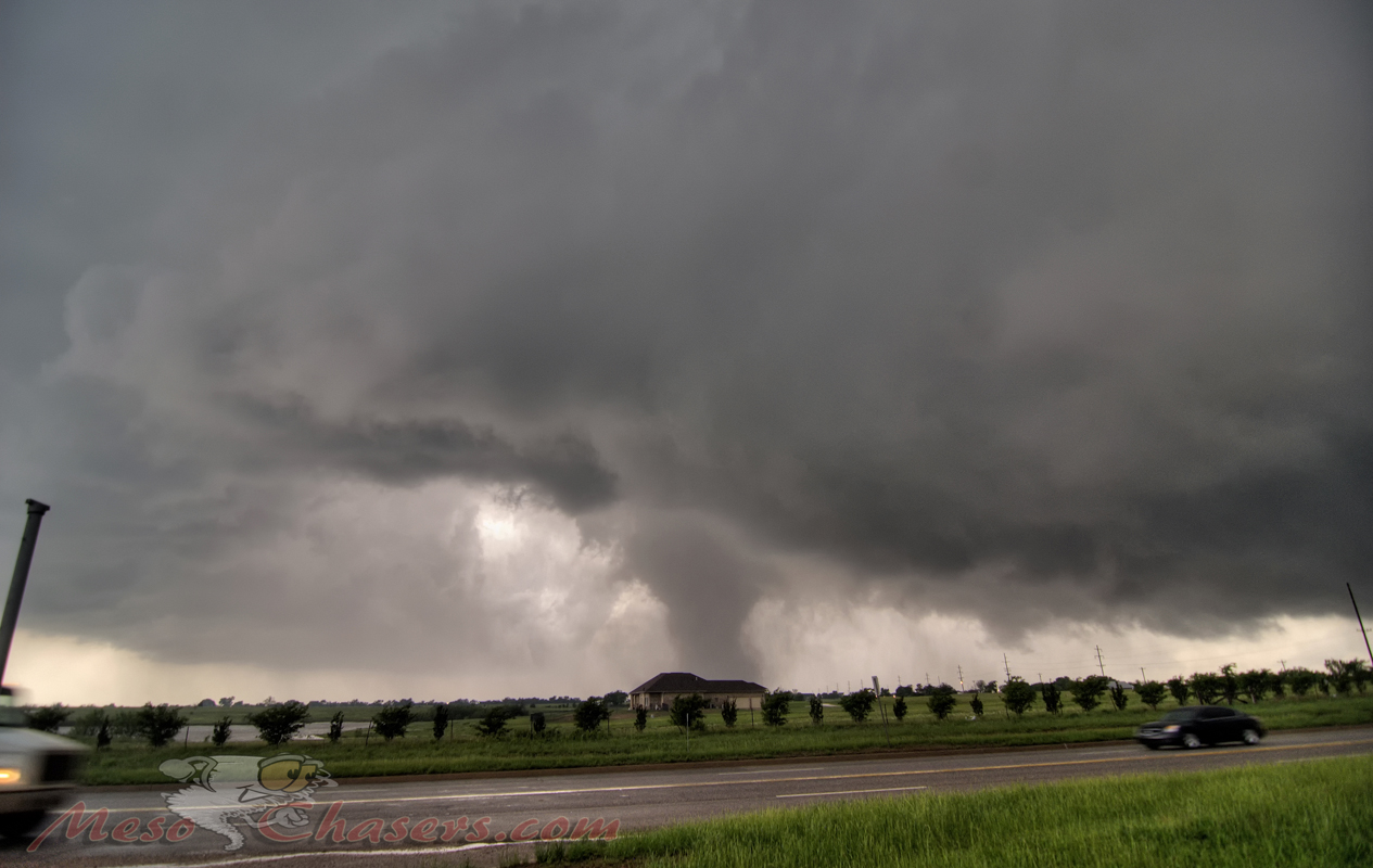
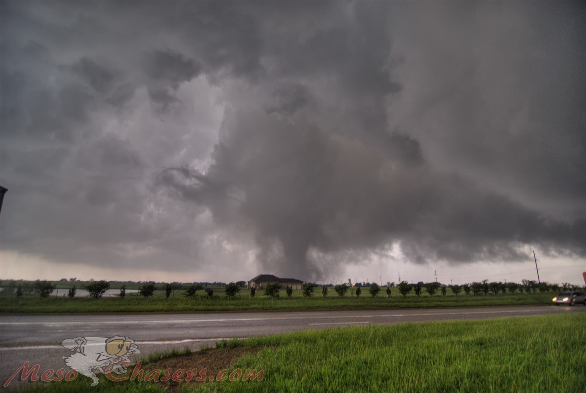
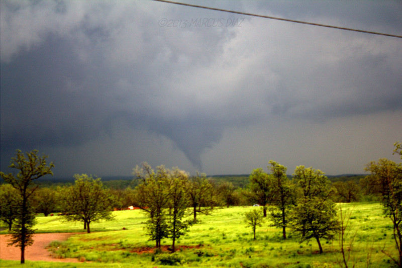
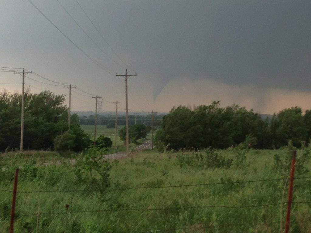
As we watched the storm we noticed rapidly rotating rain curtains. It was hard to see what was in there. I couldn't tell if there was a tornado on the ground or not. But, then it dropped that elephant trunk and there was no mistaking it. I called family to let them know we were out of harms way. I then called daycare to let them know there was a tornado on the ground. Withing minutes the elephant truck transformed into a wedge. When the tornado stopped its northeasterly motion, we repositioned 1 mile further south and west at Franklin and Santa Fe/48th. This is just next to the south doppler radar.

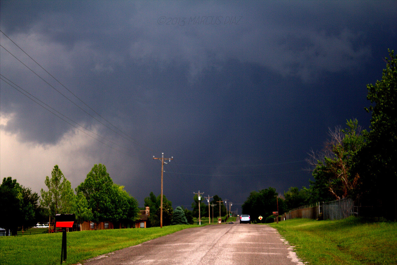
I only took 1 picture of the tornado. I was just too dumbfounded watching this thing roll through my old neighborhood. When the tornado got closer and remained a large and growing wedge, I called daycare one last time to let them know that this was a very serious tornado. The tornado was visible from our location until it got to about 149th and Western. At that point it became impossible for me to actually see the tornado. There was dirt and debris circulating around it for more than a full 1 mile section. It was due north of my location at this point. I can remember the fear and knots in my stomach as I watched. I was confident that it didn't hit our new house because I could still see the large flag at the Harvest Church in Norman. But, I was certain that it went right through the old neighborhood. I could see power flashes when the tornado became obscured. By the time it got to I-35, I was too far on the SW side to see anything. We waited a little longer and then went to make sure our house was there. It took 30 minutes to go 0.75 miles on telephone Rd to get home. Luckily we were about 1.5 miles away from the tornado path. There was debris littered throughout our yard. We were without power, cell reception, tv and internet. But we were safe.

I was able to fire up my radio to listen to the aftermath that night. It sounded catastrophic. All night long we could hear the ambulances going up and down telephone road. Still today, 2 days later, there is the constant noise overhead of helicopters flying non-stop. Slowly I was able to get messages from some of my old neighbors. They said half the homes on my old street were gone or severely damaged. Our old house sustained probably EF-1 damage from my best guess. My neighbor directly across the street to the north had EF-3. I learned today that NWS found EF-5 at Briarwood Elementary. The school is only 250 yards away from the old house. Luckily the tornado narrowed after crossing I-35 and spare our daycare. It received EF-0 damage. Not more than 200 yards north it goes to EF-3 and EF-4 (300yds). I am thankful that everyone on my old block is alive and safe.

My prayers go out to all in Moore.

I can't figure out how to upload my photos.
 
Last edited by a moderator:
Moderator Note

Administrative Note:

The Moore tornado and its aftermath has generated a lot of great discussion here, which is awesome in that one respect - lots of great observations, ideas and meteorological substance is being shared. In keeping with the rules for the Target Area, I moved some of the non-report posts to the following ongoing discussion thread in Advanced Weather and Chasing that is serving the purpose of facilitating general discussions that are NOT related to first-hand chase accounts from May 20th: https://stormtrack.org/community/threads/the-destructive-moore-tornado.26776/.

As a friendly reminder for the purpose of facilitating consistency and reducing non-chase report discussions in REPORTS threads (i.e., clearing some "noise" from actual chase report summary posts), only first-hand chase reports should be posted in an actual REPORTS thread:
Thread types
FCST is for your original forecasts and nowcasts for the event. REPORTS is for sharing your own storm chase experience for the day (do not reply in-thread with questions or comments). MISC is for all other discussion of the event which doesn't fit into those categories (including talking about other peoples' storm chases or asking about them).
 
I opted to play further south on the dryline on Monday, targeting Chickasha, OK. After arriving at the initial target and looking over surface data, a couple of cells began forming southwest of Chickasha, between Duncan and Lawton. I watched the initial cell, which moved just south of Chickasha, but another cell closer to Duncan was exhibiting stronger mid-level rotation, so our group opted to stick with that cell, assuming it might have a better environment to work with, possibly even being influenced by a remnant boundary from the first cell.

As we dropped south of Hwy 29 near Bray, the storm began exhibiting stronger inflow and produced a brief tornado south of Marlow. The tornado lifted, so we repositioned near Clear Creek Lake and watched as a new tornado touched down south of Marlow and tracked ENE for about 5-10 minutes, producing a nice cone, stovepipe and an incredible rope out. The tornado had very poor visibility at first, and I didn't have time to tripod the first part of its cycle, but we were able to watch a pretty tornado over mostly open country before the tornado lifted. After that the storm could never muster the ability to produce another tornado, at least from my vantage point, as it became outflow dominant as it moved towards the I-35 corridor.

Watch video >
 
I'm a little late to the party, but I thought I'd throw this out there. I didn't actually get to chase that day. Unfortunately, I had to deal with the tornado on a more personal level. I got a little brave (and potentially stupid), and I took a quick 6 second video of the tornado as it was bearing down on us. After experiencing this, I'm not sure I'll be chasing as much as I used to. Quite the sobering experience. Watch video >
 
Back
Top