• A friendly and periodic reminder of the rules we use for fostering high SNR and quality conversation and interaction at Stormtrack: Forum rules

    P.S. - Nothing specific happened to prompt this message! No one is in trouble, there are no flame wars in effect, nor any inappropriate conversation ongoing. This is being posted sitewide as a casual refresher.

2022-05-31 REPORTS: TX/OK/KS

Randy Jennings

Supporter
Joined
May 18, 2013
Messages
767
Inital target was Childress TX. Headed NW from there . Saw lightning start a wildfire and we reported it to 911. Played it slow to allow hail core to cross 287 south of Memphis TX then went to messure hail. My chase partner Chadwick Stelzl got out in the pouring rain to collect hail. Here is the picture sent to NWS Lubbock that got the largest hail LSR of the day at 3.5 inches.

1654101518102.jpg

A little while later he found a 4 in one and we reported it, but as of now has not been entered as a LSR.


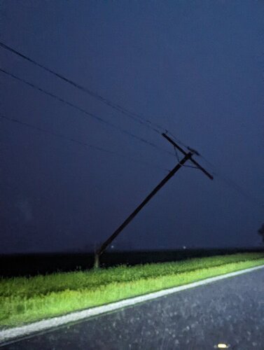
Lots of busted car windows in the area. We left just in time to avoid another hail core and took some 1.25 hail driving thru Memphis. We went north and east before cutting between two cells to get back in the right flank. Most of what we saw the rest of the day was shelf/outflow, but a few times it would develop an inflow notch on leading edge and start to lower like this:

1654101612223.jpg

None of the notches we where on produced or got tor warned, but a few did get tor warned ( after we left that area of the storm). Roads in the area are limited especially in Texas and near rivers. We made a loop in TX, then looped into OK and back into TX. A fun chase with low expectations that capturing gorilla hail without any vehicle damage made it special.
 
Mods can we add IL to this thread. I observed a slow moving supercell last night embedded eventually into a convective complex in McDonough County, IL. I was out photographing lightning when a tornado warning came across my phone. I dropped south of Macomb and then west and eventually followed the circulation east. I documented at least 1 multiple vortex tornado, possibly another earlier on, however NWS surveys are out this morning showing a high end EF-1 tornado with 110 mph winds did damage to outbuildings, trees, and a 1/4 mile stretch of power poles along highway 67. This was quite an intense and unexpected chase given the low potential (<2% tor outline at 8pm). I'm thinking an outflow boundary aided in this storm in being tornadic...in adidtion was a prolific lightning producer.

_DSC5633.jpg

Screen Shot 2022-06-01 at 2.02.24 PM.png

2 lightning shots approaching the tornadic supercell from the N.

Industry Tornado.png
An impressive wall cloud comes into view with a cone funnel NW of Industry, IL (in between the trees and during lightning and power flashes).

_DSC5680.jpg
Clearing the trees onto flat terrain minutes later reveals a stout multiple vortex tornado ongoing with a large wall cloud and mesocyclone above. Power poles blocked my path and I was forced to retreat west into nearly hurricane force wind gusts in the RFD. NWS Quad Cities confirms EF-1 damage with 110 mph with this, bordering on a siggy tor.

_DSC5685.jpg
It did not take long for the tornado to becoming rainwrapped near Industry, this second grab just 30 seconds later shows how grainy the video capture was (first 1 was a DSLR shot, second a video grab) and how low the contrast was becoming.

I was back at home by midnight in my own bed after navigating flooded roadways and damage. Several areas south of here received 3-4"+ of rainfall that we don't really need.
 
Got home last night from Wichita and I wasn't home 30 minutes when the phone went off for a tornado warning here locally. Headed out and got in front of the supercell and was able to do a night time intercept. I came in behind the tornado and was able to see the v-shaped cone hugging the ground but could not confirm any ground circulation at the time and due to driving and obstruction of trees I do not have any good footage of the funnel. I did help with some damage assessment this morning in the Industry area and attached some of the photos of that, as well as one of the power poles that snapped near me last night on US 67 between Macomb and Industry.
 

Attachments

  • PXL_20220601_131339691.jpg
    PXL_20220601_131339691.jpg
    192.1 KB · Views: 0
  • PXL_20220601_124602354.jpg
    PXL_20220601_124602354.jpg
    337 KB · Views: 0
  • PXL_20220601_132802059.jpg
    PXL_20220601_132802059.jpg
    153.8 KB · Views: 0
  • PXL_20220601_125305030.jpg
    PXL_20220601_125305030.jpg
    293.2 KB · Views: 0
  • PXL_20220601_040627958.jpg
    PXL_20220601_040627958.jpg
    87.9 KB · Views: 0
  • PXL_20220601_125507277.jpg
    PXL_20220601_125507277.jpg
    312.3 KB · Views: 0
  • PXL_20220601_133210531.jpg
    PXL_20220601_133210531.jpg
    528.5 KB · Views: 0
Initially targeted Clarendon to play the stationary front. We started the day in Ponca City, and the front was draped through OK as well, but I was expecting there to be an intersection with the dryline near Clarendon which is why we drove so far west. Ultimately there really wasn't much of a dryline evident in the surface obs.

We observed some bubbling Cu on the front...

File Sep 12, 11 56 09 AM.png

... and later got on our first cell near Wellington, TX...

wellington 0713.PNG

Shortly thereafter, the cell exhibited some transient supercell structure, and the precip core made for a nice photo op.

core AM.png

We moved east to stay with it and keep an eye on things. There were not a lot of road options in the area. About 45 minutes later, cells were starting to congeal with the newer convection to the SW...

radar.PNG

As you can see, we were on the lead cell that had now gone into OK, with at least two other cells extending SW to Memphis. We picked a spot on a north road to let the more-southerly storms come toward us. Never really saw the first updraft again, but got this pic of the second or third storm in the line.

distant new AM.png

As this cluster of storms continued to congeal, we bailed for storms just north of I-40 from Elk City to Weatherford OK. My saved radar image at just before 6pm CDT shows a cell near Sweetwater that we were approaching. I honestly can't remember why I didn't go after this one... I think I liked the cells north of I-40 better because surface obs showed better moisture in the area. We continued north from Erick up to I-40 and blasted east (I-40 actually was oriented NE at that point) to intercept storms then near Foss. Finally caught up at Clinton, where an appendage had now grown southward from the storm and was extending over I-40. No rotation apparent, and there was no TOR warning, so we continued on through the very heavy rain. Once emerging, on the SE flank of the storm - now in Weatherford - all we saw was a big huge HP core. We got off the interstate and just allowed it to just run over us, getting this pic of the whale's mouth.

whales mouth PM.png

Meanwhile, of course, one of the storms from the southern cluster that we had bailed on now had a TOR warning...

We went west to Clinton to stay for the night. Found a great Mexican restaurant called Canelo's Mexican Grill and Bar. Great food, menu selection, really friendly server. Lots of other chasers staying at our hotel, including the Texas Tech radar trucks. Storms continued through the night; my son told me the power went out at one point.
 
Back
Top