cdcollura
EF5
Good day all, this is my reports for May 13, 2023 in Iowa...
Summary: May 13 was a rather interesting chase day with two important target areas available for storm chasing. One was a region near and east of Des Moines, Iowa, and another to the northwest in northwestern Iowa - Both of which produced tornadoes. The latter NW target area was my choice, playing the weakening cold-core setup. Looking at data, a nearly stacked low-level and upper-level low was nearing the NE Nebraska to NW Iowa area, with an occluded front arching east and southeast from there to an apex (warm front and cold front occlusion point) near Des Moines. The SPC had the target area(s) in a 5% tornado probability slight-risk, with hail and wind both 15%. I headed east out of Sioux City into Iowa via Highway 20 east. Towering clouds were noted looking east along the sharp occluded boundary while heading east. By early afternoon, I went north of Highway 20 via Highway 59 towards Cherokee County. The SPC issued MCD 786 for the target areas, with subsequent tornado watch box 223, valid until 7 PM CDT. Chasing of storms in this area was from about 1 PM through 7 PM, anywhere from near Storm Lake, Sac City in Sac County, and Pocahontas - Around Highways 59 and 71, and SR 3 and SR 7. Many small mini-supercells were encountered in this area, with 5 to 6 tornadoes (most weak) observed. I wrapped up chasing by evening and headed back down to Highway 20 and took that east to I-35. I went south on I-35 to Des Moines, then east on I-80 to Iowa City for the night.
Full online chase log for 2023 (including this one) can be found here: www.sky-chaser.com/mwcl2023.htm
Details (on May 13)...
1). May 13, 4:00 PM - Observation and penetration of multiple strong to severe, and tornadic storms, training in an area near Storm Lake and Pocahontas, Iowa in Cherokee and Sac Counties, and north of Highway 20 and near Highway 71. These were multiple (like a dozen or so) classic mini-supercell storms, training from SE to NW in an arc - This will be logged as one intercept / observation for that matter. These small supercells exhibited strong rotation in the low-levels, with at least 5 or 6 weak tornadoes observed and documented. One weak tornado passed right over my location, with 60 to 70 MPH winds (EF-0 probably). Another tornado was observed at close-range crossing a field and barely missing a farmstead near Schaller. Another large, multi-vortex tornado, was observed looking north from SR 7 near Fonda (the low cloud base gave it a "wedge" appearance at one point)! These tornadoes mainly missed any structures and / or were in open fields. In addition to the multiple tornadoes, the store cores had 50 MPH winds, torrential rains, and small hail at best. Little or no lightning was observed with these low-topped mini supercells. Documentation was digital stills and HD video. Conditions causing the storms were surface heating, a low pressure area, an occluded warm front, and a weakening upper-low (cold-core). A 2022 Jeep Renegade was used to chase the storm. A tornado watch was valid for the area until 9 PM CDT.
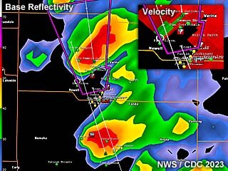
Above: This is a radar image (base reflectivity) of a arching line of supercells at roughly 4:30 PM CDT north of Sac City, Iowa. These were mainly low-topped mini supercells. The subtle velocity is in the upper-right inset as well.
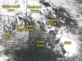
Above: This an annotated visible satellite image at roughly 20z (mid to late afternoon) on May 13, 2023. An upper level low is weakening to the upper-left in the image, with an occluded front extending southeast from a surface low under the upper low. The target area is to the east of the upper low and along the warm-frontal occlusion (cold-core setup).
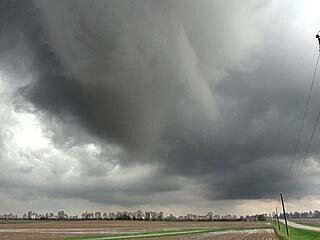
Above: Developing tornado and funnel (to the left) looking south near Storm Lake, Iowa just before 2 PM CDT on May 13.
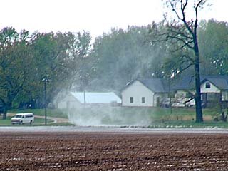
Above: Contact swirl from a tornado in an open field as it makes ground contact about 1/4 mile from my location looking southwest while south of Storm Lake, Iowa just before 2 PM CDT on May 13. The tornado fortunately missed the houses in the background.
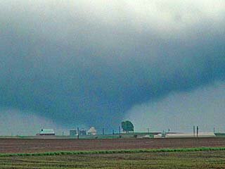
Above: Impressive wedge / multi-vortex tornado looking northeast from near Fonda, Iowa.
Summary: May 13 was a rather interesting chase day with two important target areas available for storm chasing. One was a region near and east of Des Moines, Iowa, and another to the northwest in northwestern Iowa - Both of which produced tornadoes. The latter NW target area was my choice, playing the weakening cold-core setup. Looking at data, a nearly stacked low-level and upper-level low was nearing the NE Nebraska to NW Iowa area, with an occluded front arching east and southeast from there to an apex (warm front and cold front occlusion point) near Des Moines. The SPC had the target area(s) in a 5% tornado probability slight-risk, with hail and wind both 15%. I headed east out of Sioux City into Iowa via Highway 20 east. Towering clouds were noted looking east along the sharp occluded boundary while heading east. By early afternoon, I went north of Highway 20 via Highway 59 towards Cherokee County. The SPC issued MCD 786 for the target areas, with subsequent tornado watch box 223, valid until 7 PM CDT. Chasing of storms in this area was from about 1 PM through 7 PM, anywhere from near Storm Lake, Sac City in Sac County, and Pocahontas - Around Highways 59 and 71, and SR 3 and SR 7. Many small mini-supercells were encountered in this area, with 5 to 6 tornadoes (most weak) observed. I wrapped up chasing by evening and headed back down to Highway 20 and took that east to I-35. I went south on I-35 to Des Moines, then east on I-80 to Iowa City for the night.
Full online chase log for 2023 (including this one) can be found here: www.sky-chaser.com/mwcl2023.htm
Details (on May 13)...
1). May 13, 4:00 PM - Observation and penetration of multiple strong to severe, and tornadic storms, training in an area near Storm Lake and Pocahontas, Iowa in Cherokee and Sac Counties, and north of Highway 20 and near Highway 71. These were multiple (like a dozen or so) classic mini-supercell storms, training from SE to NW in an arc - This will be logged as one intercept / observation for that matter. These small supercells exhibited strong rotation in the low-levels, with at least 5 or 6 weak tornadoes observed and documented. One weak tornado passed right over my location, with 60 to 70 MPH winds (EF-0 probably). Another tornado was observed at close-range crossing a field and barely missing a farmstead near Schaller. Another large, multi-vortex tornado, was observed looking north from SR 7 near Fonda (the low cloud base gave it a "wedge" appearance at one point)! These tornadoes mainly missed any structures and / or were in open fields. In addition to the multiple tornadoes, the store cores had 50 MPH winds, torrential rains, and small hail at best. Little or no lightning was observed with these low-topped mini supercells. Documentation was digital stills and HD video. Conditions causing the storms were surface heating, a low pressure area, an occluded warm front, and a weakening upper-low (cold-core). A 2022 Jeep Renegade was used to chase the storm. A tornado watch was valid for the area until 9 PM CDT.

Above: This is a radar image (base reflectivity) of a arching line of supercells at roughly 4:30 PM CDT north of Sac City, Iowa. These were mainly low-topped mini supercells. The subtle velocity is in the upper-right inset as well.

Above: This an annotated visible satellite image at roughly 20z (mid to late afternoon) on May 13, 2023. An upper level low is weakening to the upper-left in the image, with an occluded front extending southeast from a surface low under the upper low. The target area is to the east of the upper low and along the warm-frontal occlusion (cold-core setup).

Above: Developing tornado and funnel (to the left) looking south near Storm Lake, Iowa just before 2 PM CDT on May 13.

Above: Contact swirl from a tornado in an open field as it makes ground contact about 1/4 mile from my location looking southwest while south of Storm Lake, Iowa just before 2 PM CDT on May 13. The tornado fortunately missed the houses in the background.

Above: Impressive wedge / multi-vortex tornado looking northeast from near Fonda, Iowa.
Last edited:
