• A friendly and periodic reminder of the rules we use for fostering high SNR and quality conversation and interaction at Stormtrack: Forum rules

    P.S. - Nothing specific happened to prompt this message! No one is in trouble, there are no flame wars in effect, nor any inappropriate conversation ongoing. This is being posted sitewide as a casual refresher.

2011-05-24 El Reno OK EF-5

Joined
May 6, 2005
Messages
276
Location
Moore, OK
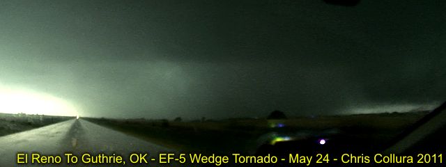
Norman NWS has upgraded the Calumet-El Reno-Piedmont-Guthrie tornado to an EF-5.

The topic of discussion is their use of mobile radar to provide the EF-5 designation.

It is my understanding they measured a 125 m/s wind at 62 meters above the ground near the Calumet exit on I-40. Once extrapolated to the ground winds were likely above 210 mph.

I think the results of this field study show the flaws in the Enhanced Fujita Scale. If not for the mobile radar sampling the storm at the exact place it did, this storm would likely be rated as an EF-4 since the homes that were destroyed were not structurally able to withstand winds of EF-4 magnitude.

It is plausible that all three significant tornadoes in Oklahoma on 05-24-2011 were EF-5s, but not all of them had mobile radars sampling the storm. I heard that each significant tornado completely wiped houses off their foundations, but again the houses weren't built strong enough to withstand EF-4 winds.


STORM 3... CALUMET-EL RENO-PIEDMONT-GUTHRIE

PRELIMINARY DATA...
EVENT DATE: MAY 24, 2011
EVENT TYPE: TORNADO
EF RATING: EF-5
ESTIMATED PEAK WINDS (MPH): GREATER THAN 210 MPH
INJURIES/FATALITIES: UNKNOWN/9
EVENT START LOCATION AND TIME: 4 ESE HINTON 3:50 PM CDT
EVENT END LOCATION AND TIME: 4 NE GUTHRIE 5:35 PM CDT
DAMAGE PATH LENGTH (IN MILES): 65 MILES
DAMAGE WIDTH: TO BE DETERMINED
NOTE: RATING BASED ON UNIVERSITY OF OKLAHOMA MOBILE DOPPLER RADAR
MEASUREMENTS.
 
This is the first that I have heard of this happening. Other mobiles have been intercepted - but I do not think that the rating was derived from the proximity.
For one, I am glad that there was a mobile right there. I believe there has been an underestimation of windspeeds according to damage for some time now. The data that was gathered by this accidental incident can, hopefully, help to provide more information leading to a more accurate standardized scale.
 
Last edited by a moderator:
A Doppler On Wheels measured the Bridge Creek, OK (later the OKC/Moore) tornado on May 3, 1999 at 301mph (originally 318mph). Actually think 2 DOWs may have been on it at the time. Later that night the DOW images from the Mulhall, OK tornado show a hurricane like eye and the tornado was likely larger than than the BC/OKC/Moore, OK tornado but was rated F4. The DOWs proximity allow the beams to cut at lower levels and give a more enhanced view of the storms. Great tools.
 
I hope more attention is given to this tornado, or series of tornadoes... they've kind of been lost in the mix of Joplin, and then I believe the day it was announced as EF5, the tornadoes were hitting Massachusetts. Most years this would be the major tornado event of the year... just not this year.
 
I think this may also be a discussion on rating tornadoes on damage versus actual wind speed. Obviously not every tornado will have mobile radar right next to it. One question I have is what is the difference between this tornado and other tornadoes that have been rated EF5 based on damage? What little thing affects the rating?
 
The vertical profile of horizontal (or the full 3D) wind in tornadoes is not well understood. This was one of the main goals of VORTEX 2, but Mother Nature did not give us much of an opportunity to examine the relationship between near-surface (e.g. 2-10 m) winds and those observed by radar above the surface (50-100+ m). We are hampered by the fact that very few quantitative measurements of wind speeds within tornadoes exist. Josh Wurman and several others have done some work on this, however. One reference:

Wurman, J., C. Alexander, P. Robinson, and Y. Richardson, 2007: Low-level winds in tornadoes and potential catastrophic tornado impacts in urban areas. Bull. Amer. Meteor. Soc., 88, 31-46.

There has been a small handful of tornadoes that have used mobile radar data in their ratings. There are more than a few reasons why this is so: most data from mobile radars have not been very near the surface of tornadoes, most data have not been of high enough resolution to sample the actual tornado (which typically requires that the tornado be very near the radar), and vast majority of tornadoes have not been sampled by any mobile radars. In addition, if there are significant DIs that can serve to provide an upper-bound to the wind velocity estimates, then there typically isn't a need for any radar data, since the damage can provide proper bounds (lower and upper). In cases in which all DIs affected have maximum DoDs, then it's difficult to determine an upper-bound to a wind estimate.

In this particular case, we (Bluestein, Houser, and I) collected data (in RaXPol, our new rapid-scan, X-band, polarimetric mobile Doppler weather radar) at relatively close range (as close as 3 km, as far as ~15 km before we lost the tornado as a result of attenuation), with the lowest elevation angle at 1 degree. The radar beam was centered ~60-80 m above radar level when we sampled wind speeds currently associated with EF5. For what it's worth, these were not borderline radial velocities -- the observed peak velocities are significantly greater than the EF4/EF5 threshold. When I'm given the nod, I will happily give specific numbers publicly. Unfortunately, I need to be a bit ambiguous publicly until we have time to unfold every scan and examine the data in much greater detail than we've been able to do thus far. We will also likely need to perform some error analysis to estimate some error bars for the calculated peak velocities (considering spectrum width, the likely median height of scatterers within the resolution volume, etc.). If one thinks that radar can supply some value for the assessment of a tornado, though, then I think these (RaXPol) data are nearly as good as we can hope to have (if we were in a completely flat, tree-less area, we may have been able to scan at 0 degrees elevation, I suppose). Note that some non-traditional damage indicators were used in the rating of this tornado, largely because the tornado did not hit any DIs strong enough to be used to classify an EF5 tornado. Whether certain high-end DIs (only several of which can be used in an EF5 rating) are hit is essentially just luck, which is a significant source of potential error in the EF scale if one of the goals is to use damage to estimate tornado intensity.

EDIT: We did not have any direct role in the rating of this tornado. We provided the data to NWSFO OUN and some members of the assessment team. Howie strongly stressed that we let the data speak for themselves without any opinion as to whether or not the radar data should be considered when assessing the tornado. Remember, nearly all mobile radar data are not at ground level (2-10 m), and radars themselves measure the weighted mean velocity of the scatterers within the radar resolution volume, not the actual radial velocity of the air.
 
Last edited by a moderator:
You must also consider that since MAN built a structure that it will inherintly be flawed, as NOTHING that is built and tested to a "standard" is actually built in the real world. A structure or componet that is built and tested say by UIL (or other recoginized testing agency) will always be the most "perfect" as it can be so that it will receive a favorable rating. THis DOES NOT translate to what actually gets built in the real world. Another reason that structural engineers, TRAINED to evalaute building materials and construction methods should always be part of an assessment team. As an example, the Arlington, TX toronado was originally rated and EF2 until structural engineers completed their assessment. Then it was downgraded to an EF1 due to lack of brick ties, failure to tie the structure to the foundation and incorrectly installed garage doors. Texas Tech and all of the others have done an admirable job in developing the EF scale but no one can account for sloppy contractors, construction workers or construction methods.
 
I think the results of this field study show the flaws in the Enhanced Fujita Scale. If not for the mobile radar sampling the storm at the exact place it did, this storm would likely be rated as an EF-4 since the homes that were destroyed were not structurally able to withstand winds of EF-4 magnitude.

I agree. I think the upper end of the EF wind speed range leaves a lot to be desired. And I for one don't like the open ended nature of the top end of the scale...it creates the discontiunity between historical tornadoes and tornadoes in the current system. Hopefully research like this will allow the scale to be more accuratley revised. There has to be a happy middle ground between "estimated" winds in the Fujita scale and "in excess" open ended winds in the EF scale.

It is plausible that all three significant tornadoes in Oklahoma on 05-24-2011 were EF-5s, but not all of them had mobile radars sampling the storm. I heard that each significant tornado completely wiped houses off their foundations, but again the houses weren't built strong enough to withstand EF-4 winds.

Very true, and I'll take it a step further. I think you may have the same potential issue in Tuscaloosa/Birmingham. I think that tornado is very close to EF-5, but the structures it hit were really not designed to withstand EF4 winds.

And one last side note, it's really cool to see the radar data used in the damage survey. Going back historically, a lot of folks believe the 26 April 1991 Red Rock tornado was of F5 intensity based on Howie's radar measurements!
 
Last edited by a moderator:
So, all of those EF-4's last year could have been EF-5's if they had a doppler scanning them. Doesn't that skew the historical data?
 
@ Jeff:

Thanks for responding to the thread concerning the El Reno tornado. I am curious, were you guys the only ones sampling the storm with mobile radar? Also, the last time I was at OU ('07) Dr. Biggerstaff was building the dual polar, X-band (I think? or perhaps it was C-band) mobile radar. What type of radar was Howie's team using?

Do you know if anyone else tried sampling the Chickasha or Goldsby storms?

Another interesting note is that I could not find a 00z 05-25-2011 sounding for OUN. I understand that NWSFO OUN was pretty busy at the time and they had a tornado warned storm very near or overhead (I read SPC took shelter and used their backups), but could you imagine launching a sounding directly into a tornadic supercell...

I am not sure how high the balloon would have gone, but there is the possibility that if the instrument made it into the updraft that the force of the updraft may have continued to lift it higher into the storm. I remember Jeff Snyder discussing the potential problems with proximity soundings during case studies (I believe this was on the busted tornado watch 05-19-2011?) and this would have been a great chance to sample a tornadic environment which would give us the opportunity to see if proximity soundings are indicative of the nearby environment.

Does anyone know if NWSFO OUN launched any soundings between 18z 05-24-2011 and 00z 05-25-2011?

Thank you to everyone for the discussion!
 
So, all of those EF-4's last year could have been EF-5's if they had a doppler scanning them. Doesn't that skew the historical data?

Not necessarily. There are some tornadoes that have proper upper-bound estimates. For example, if a short-lived tornado goes through a town, and all high-end DIs (e.g. schools) do not show damage consistent with EF5 winds in areas that are otherwise thought to have seen the strongest winds, then it's more likely that you can establish an upper estimate of the winds. We see this with most of the weaker tornadoes -- houses in a neighborhood may only have some minor roof damage (EF0 - EF1), so it's quite unlikely that the tornado had 150+ mph winds in that area. When no affected high-end DIs "survive" a tornado, however, it's much more difficult to define that upper bound. If a bunch of homes are "slabbed", we can only know that winds were at least 1xx mph. For all we know, they may have been 2xx or 3xx mph -- the fact that everything we destroyed completely just means that we can estimate that winds are at least some value. It'd be nice to have some way to differentiate the former cases (in which an upper-bound can be established with some confidence) from the latter cases (where no upper bound can be properly established as a result of a lack of "surviving" DIs). Perhaps it'd be better to refer to these tornadoes with a modified, such as "EF4+", indicating that the tornado was at least an EF4. There may be no evidence to suggest that the particular tornado was an EF5, though there also may be no evidence to suggest that it wasn't an EF5.
 
Last edited by a moderator:
@ Jeff:

Thanks for responding to the thread concerning the El Reno tornado. I am curious, were you guys the only ones sampling the storm with mobile radar? Also, the last time I was at OU ('07) Dr. Biggerstaff was building the dual polar, X-band (I think? or perhaps it was C-band) mobile radar. What type of radar was Howie's team using?

Do you know if anyone else tried sampling the Chickasha or Goldsby storms?

Brian - As far as I know, we were the only ones on the El Reno storm at the time we collected data. We actually had both of our radars (RaXPol and MWR05XP) on the El Reno supercell/tornado. Details of the data collected will serve as the topic of at least a couple of publications through the next couple of years. We certainly realize that a dataset like this doesn't come along very often.

After the El Reno tornado moved into the range of signal extinction, we opted to leave that supercell since we didn't think we'd be able to get ahead of it again. So, we dropped south and east, collecting data again just N of Newcastle. From this location, we collected close-range data of the weakening Chickasha tornado, from the time the tornado was near Newcastle until it dissipated in extreme southwestern Oklahoma City. We also were able to scan the relatively distant Goldsby supercell.

Dr. Biggerstaff works with the SMART-R radars, (at least) one of which has dual-pol capabilities. The SMART-Rs are C-band radars.
 
Last edited by a moderator:
And I for one don't like the open ended nature of the top end of the scale...it creates the discontiunity between historical tornadoes and tornadoes in the current system.

I'm not sure I follow... An F5 from the old days is comparable to an EF5 today unless I'm missing something?
 
You know, over the years I got it drilled into my head that the F Scale, and now the EF Scale, was strictly a damage rating from which wind speeds could be derived, not a wind speed rating per se. I had a hard time grasping this at first; I had thought it was primarily intended as a wind speed rating, but I finally bought into the idea that wind speeds were secondary. In discussions on the matter in ST, I remember reading emphatic statements like, "The F Scale is a damage rating, period."

Has this changed since the adoption of the EF Scale? Informative though it may be, a Doppler radar reading is nevertheless not a damage indicator, it's a wind speed measurement. Obviously it can be used to extrapolate a tornado's damage potential, but that's not the same thing as using real damage to extrapolate wind speeds, which is what I've always been told the F/EF Scale is meant to do.

I don't mind modifying my understanding of the EF Scale to incorporate Doppler radar measurements. But that approach to me plainly indicates that the scale is now really about wind speeds. It also implies the introduction of a third component: not just damage and estimated wind speed, but also potential damage, the kind of damage a tornado could do if it hit various DIs, even though it may have hit nothing.

So my question is this: Conceptually, exactly what is the EF Scale these days?
 
Last edited by a moderator:
Good day all,

m12tor19.jpg


Above: The view from Highway 270 (3 miles south of Calumet), looking south, and roughly 2 miles north of I-40. Image is from video frame-grab and contrast adjusted from low-light issues. I came close to driving into this one had I not "heard it" too!
 
So my question is this: Conceptually, exactly what is the EF Scale these days?

Interesting question - and I think time for a mod to make this a new thread.

The "official" EF-scale training at WDTB says that the wind speed numbers can change with time to keep damage consistent based on new research. So the EF4 being 166-200mph today could theoretically be changed to 175-210mph tomorrow. Then what do you do with the tornado that was rated EF5 because DOW ground winds were 205mph?

On the other hand, the TTU report back from 2006 says "The technology of portable Doppler radar should also be a part of the EF Scale process, either as a direct measurement, when available, or as a means of validating the wind speeds estimated by the experts." So I guess that answers the question.

I do recall hearing something about the EF committee coming back alive for revisions maybe 6 months ago, but neither SPC nor WDTB's page has any mention of it. And a meeting without minutes never really happened, right ;) (PS if anyone from WDTB and SPC reads this, many of the links on your page, like the TTU report, are broken.)
 
From a wind engineering standpoint, the issue is how a volumetric radar velocity measurement relates to a conventional 3-sec gust. All structural design standards are based on a 3-sec gust at 10 m. Throw in as Jeff mentioned, the lack of information/understanding of the vertical wind profile in tornadoes and it is a multi-faceted problem. This highlights a research need to understand how radar measurements relate to conventional Eulerian wind measurements. The wind engineering community is finally starting to catch on to the idea of using mobile radar platforms not just for tornadoes but for thunderstorm outflow winds in general (e.g. the current TTU project thats in the field with the 2 Ka band radars and StickNet probes, may the first field study like this funded through the engineering directorate of NSF). I think we hoped that maybe a good opportunity to start working on this problem would present itself from V2. It also continues to support the need for coordinated datasets with these multiple assets. A general feeling I get from the engineering community is that they would prefer radar information used for validation or changes to the EF-Scale rather as a way to actually assign a rating operationally.

I like Jeff's idea of the "asterix" and provides an indication of uncertainty in the rating (and for comic relief, the steriod era of tornado ratings)

Also Rob, I think TTU has moved the location of the EF-scale report, they've been doing some badly needed web upgrades in the WISE center, albeit they are going very slow.

I had to throw in a plug for my TTU guys out in the field! :eek:)
 
The bold use of an extrapolation of radar data in a singular case to hypothetical structures below only further contaminates an already questionable if not flawed tornado database. This presents continuing problems concerning the damage scale as well as for climatological research.
---------
Bill Monfredo, Ph.D.
Univ. of Oklahoma
AGS - Norman
 
I'm not sure I follow... An F5 from the old days is comparable to an EF5 today unless I'm missing something?

Specifically referring to the open upper end on wind speeds. While I know that the intention is for then EF scale to say "in excess of X mph", putting a value like 205 mph+ makes the general public assume the winds were only 205, and therefore comparebly weaker to F scale rated tornadoes. Ive heard on-air TV folks make this mistake comparing 3 May to 27 April. Its not good to compare between the two scales, but we will all do it anyway. We in the community understand the difference, most people don't.
 
The bold use of an extrapolation of radar data in a singular case to hypothetical structures below only further contaminates an already questionable if not flawed tornado database. This presents continuing problems concerning the damage scale as well as for climatological research.
---------
Bill Monfredo, Ph.D.
Univ. of Oklahoma
AGS - Norman

I disagree. It's an actual quantifiable measurement with error bands, and to ignore it does an injustice to the process I think. For example, If a tornado hits no structure and has no discernible upper DI marker, but a measurement is available and quality controlled suggesting its rating should be much higher, it should be ignored and rated lower? This defeats the purpose of the EF scale doesn't it?

The database is already flawed due to assumptions from human judgement anyway...letting the data speak for itself makes all the sense in the world to me and allows more solid entries into it.
 
Specifically referring to the open upper end on wind speeds. While I know that the intention is for then EF scale to say "in excess of X mph", putting a value like 205 mph+ makes the general public assume the winds were only 205, and therefore comparebly weaker to F scale rated tornadoes. Ive heard on-air TV folks make this mistake comparing 3 May to 27 April. Its not good to compare between the two scales, but we will all do it anyway. We in the community understand the difference, most people don't.

I see what you're saying... But the public doesn't care. Ratings are important for very little outside of the research community other than a few days of news headlines.
 
I see what you're saying... But the public doesn't care. Ratings are important for very little outside of the research community other than a few days of news headlines.

I would tend to agree in general, but the wind speed part does gets a bit more attention.
 
The "official" EF-scale training at WDTB says that the wind speed numbers can change with time to keep damage consistent based on new research. So the EF4 being 166-200mph today could theoretically be changed to 175-210mph tomorrow. Then what do you do with the tornado that was rated EF5 because DOW ground winds were 205mph?
This underscores an issue that's been bothering me over the past week through all the hoopla surrounding the 24 May ratings.

To me, it seems ideal that we should rate tornadoes based upon a fundamental intrinsic physical attribute; namely, wind speed. Because this is not practical in this day and age, we have a host of alternatives. One option is to rate solely on the basis of damage. I had been led to believe until recently that this was the role of the EF scale. The disadvantage of this methodology is that the climatological dataset will not be at all consistent with respect to the intrinsic physical properties of tornadoes, unlike other comparable rating scales in the geosciences (Saffir-Simpson, Richter, etc.). The advantage, however, is that it *will* be consistent with respect to societal impacts of tornadoes -- along the lines of the NESIS scale developed by Kocin and Uccellinni for northeast U.S. snowstorms. Put simply, one could perform with credibility a study concerning the climatology of societally-impactful tornadoes using the database of EF ratings.

When you start to mix and match rating indicators (from the two broad categories of "damage" and "observed wind speed"), the database is not consistent with respect to much at all. I suppose using mobile radar data where available brings the dataset *slightly* closer to being accurate with respect to wind speed, but surely not any closer to being consistent in that regard. Clearly, this is not just a trivial, philosophical concern; in fact, the three primary supercells on 24 May are a microcosm of the issue. Based upon how their 88D signatures compared with El Reno, it's conceivable that the Chickasha and Goldsby tornadoes might well have earned EF-5 ratings on the basis of close-range mobile radar data, too, were it available. But because it isn't, they will go down in the record as being the "weaker" of the three tornadoes that day, despite the actual DI's being comparable for all three events. So it seems to me that the rating book for 24 May will be consistent neither with respect to damage nor wind speed.

I had been pondering this for a few days, but the point rdale just made regarding the possibility of wind speed estimates changing really hit the point home for me and motivated me to speak my mind. The fact that the wind speeds corresponding to each EF rating are explicitly stated to be flexible over time implies that it is, first and foremost, a damage scale. Therefore, I do view upgrading a rating strictly on the basis of remote sensing data to be a "contamination" of the dataset, in some sense.

To be clear, I am not specifically taking issue with NWS OUN, the QRT, or anyone involved in this conundrum. It so happens that there was non-DI damage (an oil rig, I believe) that secondarily helped to justify the upgrading of El Reno, so the concerns I laid out above are more hypothetical and apply to future events in which no physical damage whatsoever can be used in tandem with radar data.
 
I would tend to agree in general, but the wind speed part does gets a bit more attention.

It does for a few days, and maybe a bit longer for those directly impacted, but that's it. I dare you to give me any MPH numbers from any tornado you chased in 2008 off the top of your head.
 
Back
Top