cdcollura
EF5
Good day all, this is my reports for June 22, 2023 in Colorado...
Summary: June 22 was a pretty busy chase day, without the need for a long ferry to a distant target area. There were two attractive areas to target, one in northeastern New Mexico, and another from near Denver, Colorado and northward into SE Wyoming. I decided to remain in the Denver area and play the latter target area there, which turned out to be the right decision after such a frustrating previous day. A slight-risk was in place, and the New Mexico area had a 5% tornado risk as per SPC, with 2% extending north from there as far as SE Wyoming. Wind and hail were 15% (wind was hatched to the south and hail hatched in the entire outlook for significant). I left my hotel in Stapleton and headed south for lunch and waited near Centennial, watching storms fire in orographic up-slope on the front range by about 2 PM MDT. The SPC then issued mesoscale discussion 1207 and severe thunderstorm watch 358, valid until 9 PM MDT. A powerful supercell developed southwest of Denver, moving off the mountains, and producing a significant damaging tornado in Arapahoe County and evolved to a bow segment as far east as Elizabeth. I intercepted this tornado (rain wrapped) at close range near Highway 470 and south of Littleton, in very challenging suburban areas. I then headed south on I-25 to SR 86 east, past Elizabeth and into Kiowa. Hail covered the ground deeply in many places, making navigation and negotiating traffic very difficult. I headed south through Elbert to Highway 24 near Peyton, targeting another tornadic storm approaching Ramah and Simla. After this storm weakened, I went back southwest on Highway 24 to south of Peyton, and documented another weak brief tornado developing there on another supercell. I wrapped up the chase near dusk, and continued to Colorado Springs and stayed the night there off Highway 24 near the Air Force base.
Full online chase log for 2023 (including this one) can be found here: www.sky-chaser.com/mwcl2023.htm
Details (on June 22)...
1). June 22, 3:30 PM - Interception and penetration of an extremely severe and tornadic thunderstorm south of Littleton, Colorado and near Highlands Ranch in Arapahoe County and near Highway 470. The storm was a powerful classic to HP supercell storm, that evolved to an intense bow segment afterwards. This storm produced a large rain-wrapped tornado that tracked southeastwards from Littleton, past Lone Tree, and to Highlands Ranch. This tornado was observed at very close range, with inflow jets and winds gusting over 100 MPH feeding into it from the left side with low, fast moving clouds. Hail up to 2" was noted with these winds and surrounding the tornado. Damage and flash flooding was observed, with some structural damage and many trees and signs down. Power was also knocked out by this storm. Torrential rains and lightning was also encountered. Copious amounts of accumulating hail (4-6 inches deep with major traffic delays) was also noted on SR 86, west of Elizabeth, as this storm evolved to a bow segment and passed eastwards. Conditions causing the storms were surface heating, a low pressure trough, up-slope wind flow, surface boundary interactions, and an upper trough. Documentation was digital stills and HD video. A 2022 Jeep Renegade was used to chase the storm. A severe thunderstorm watch was valid for the area until 9 PM MDT.
2). June 22, 6:00 PM - Interception and penetration of a very severe and tornadic thunderstorm from near Elbert, Colorado in Elbert County and Elbert Road to northeast of Peyton along Highway 24 to near Ramah. The storm was a classic to HP supercell storm. The core of this storm was penetrated, with deafening hail up to 2" (most was about 1") driven by 60 MPH winds and heavy rains. The storm also produced frequent lightning. A possible tornado was observed later with this storm near Ramah and Simla, looking northwestwards from near Highway 24. The storm weakened via down-scale evolution there after. This storm caused flash flooding and hail was noted near Elbert with accumulations up to 6" deep. The storm also had an impressive visual appearance during its tornadic phase. Conditions causing the storms were surface heating, a low pressure trough, up-slope wind flow, surface boundary interactions, and an upper trough. Documentation was digital stills, audio, and HD video (including time-lapse). A 2022 Jeep Renegade was used to chase the storm. A severe thunderstorm watch was valid for the area until 9 PM MDT.
3). June 22, 7:00 PM - Interception and indirect penetration of another severe and tornadic thunderstorm to the south and southwest of Peyton, Colorado near Highway 24 in Elbert County. The storm was an HP supercell storm. The core was not directly penetrated. A developing weak and brief tornado was noted looking north while in the RFD / inflow "notch" of the storm southwest of Peyton. Frequent lightning, heavy rains, and small hail was also encountered. The storm was abandoned at dusk as it became rain-wrapped and evolved to a multi-cell storm cluster. Conditions causing the storms were surface heating, a low pressure trough, up-slope wind flow, surface boundary interactions, and an upper trough. Documentation was digital stills and HD video (including time-lapse). A 2022 Jeep Renegade was used to chase the storm. A severe thunderstorm watch was valid for the area until 9 PM MDT.
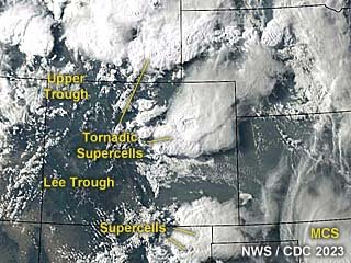
Above: This an annotated visible satellite image at roughly 0z (late afternoon) on June 22, 2023 showing the synoptic environment. Tornadic supercells are near Denver, Colorado and northward into SE Wyoming.
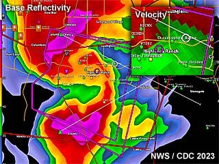
Above: This is a radar image (base reflectivity) of a tornadic HP supercell south of Denver, Colorado at roughly 3:30 PM MDT during the afternoon of June 22. A large, rain-wrapped tornado was hitting the area near Lone Tree at the time. The velocity is in the upper-right inset.

Above: Explosive development of a soon-to-be supercell storm to the west-southwest of Denver as the upper wave / trough slowly advances eastward.
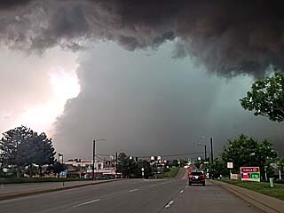
Above: Large tornado (center of photo) and complete RFD occlusion moving southeastward towards Highway 470 and Highlands Ranch. The view is to the west.
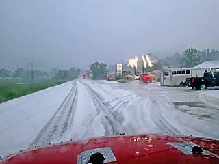
Above: Hail covers the ground, at least 6" deep in places, in Elbert, Colorado behind another developing tornadic supercell moving southeast on the tail-end of a large bow segment of severe storms.
Summary: June 22 was a pretty busy chase day, without the need for a long ferry to a distant target area. There were two attractive areas to target, one in northeastern New Mexico, and another from near Denver, Colorado and northward into SE Wyoming. I decided to remain in the Denver area and play the latter target area there, which turned out to be the right decision after such a frustrating previous day. A slight-risk was in place, and the New Mexico area had a 5% tornado risk as per SPC, with 2% extending north from there as far as SE Wyoming. Wind and hail were 15% (wind was hatched to the south and hail hatched in the entire outlook for significant). I left my hotel in Stapleton and headed south for lunch and waited near Centennial, watching storms fire in orographic up-slope on the front range by about 2 PM MDT. The SPC then issued mesoscale discussion 1207 and severe thunderstorm watch 358, valid until 9 PM MDT. A powerful supercell developed southwest of Denver, moving off the mountains, and producing a significant damaging tornado in Arapahoe County and evolved to a bow segment as far east as Elizabeth. I intercepted this tornado (rain wrapped) at close range near Highway 470 and south of Littleton, in very challenging suburban areas. I then headed south on I-25 to SR 86 east, past Elizabeth and into Kiowa. Hail covered the ground deeply in many places, making navigation and negotiating traffic very difficult. I headed south through Elbert to Highway 24 near Peyton, targeting another tornadic storm approaching Ramah and Simla. After this storm weakened, I went back southwest on Highway 24 to south of Peyton, and documented another weak brief tornado developing there on another supercell. I wrapped up the chase near dusk, and continued to Colorado Springs and stayed the night there off Highway 24 near the Air Force base.
Full online chase log for 2023 (including this one) can be found here: www.sky-chaser.com/mwcl2023.htm
Details (on June 22)...
1). June 22, 3:30 PM - Interception and penetration of an extremely severe and tornadic thunderstorm south of Littleton, Colorado and near Highlands Ranch in Arapahoe County and near Highway 470. The storm was a powerful classic to HP supercell storm, that evolved to an intense bow segment afterwards. This storm produced a large rain-wrapped tornado that tracked southeastwards from Littleton, past Lone Tree, and to Highlands Ranch. This tornado was observed at very close range, with inflow jets and winds gusting over 100 MPH feeding into it from the left side with low, fast moving clouds. Hail up to 2" was noted with these winds and surrounding the tornado. Damage and flash flooding was observed, with some structural damage and many trees and signs down. Power was also knocked out by this storm. Torrential rains and lightning was also encountered. Copious amounts of accumulating hail (4-6 inches deep with major traffic delays) was also noted on SR 86, west of Elizabeth, as this storm evolved to a bow segment and passed eastwards. Conditions causing the storms were surface heating, a low pressure trough, up-slope wind flow, surface boundary interactions, and an upper trough. Documentation was digital stills and HD video. A 2022 Jeep Renegade was used to chase the storm. A severe thunderstorm watch was valid for the area until 9 PM MDT.
2). June 22, 6:00 PM - Interception and penetration of a very severe and tornadic thunderstorm from near Elbert, Colorado in Elbert County and Elbert Road to northeast of Peyton along Highway 24 to near Ramah. The storm was a classic to HP supercell storm. The core of this storm was penetrated, with deafening hail up to 2" (most was about 1") driven by 60 MPH winds and heavy rains. The storm also produced frequent lightning. A possible tornado was observed later with this storm near Ramah and Simla, looking northwestwards from near Highway 24. The storm weakened via down-scale evolution there after. This storm caused flash flooding and hail was noted near Elbert with accumulations up to 6" deep. The storm also had an impressive visual appearance during its tornadic phase. Conditions causing the storms were surface heating, a low pressure trough, up-slope wind flow, surface boundary interactions, and an upper trough. Documentation was digital stills, audio, and HD video (including time-lapse). A 2022 Jeep Renegade was used to chase the storm. A severe thunderstorm watch was valid for the area until 9 PM MDT.
3). June 22, 7:00 PM - Interception and indirect penetration of another severe and tornadic thunderstorm to the south and southwest of Peyton, Colorado near Highway 24 in Elbert County. The storm was an HP supercell storm. The core was not directly penetrated. A developing weak and brief tornado was noted looking north while in the RFD / inflow "notch" of the storm southwest of Peyton. Frequent lightning, heavy rains, and small hail was also encountered. The storm was abandoned at dusk as it became rain-wrapped and evolved to a multi-cell storm cluster. Conditions causing the storms were surface heating, a low pressure trough, up-slope wind flow, surface boundary interactions, and an upper trough. Documentation was digital stills and HD video (including time-lapse). A 2022 Jeep Renegade was used to chase the storm. A severe thunderstorm watch was valid for the area until 9 PM MDT.

Above: This an annotated visible satellite image at roughly 0z (late afternoon) on June 22, 2023 showing the synoptic environment. Tornadic supercells are near Denver, Colorado and northward into SE Wyoming.

Above: This is a radar image (base reflectivity) of a tornadic HP supercell south of Denver, Colorado at roughly 3:30 PM MDT during the afternoon of June 22. A large, rain-wrapped tornado was hitting the area near Lone Tree at the time. The velocity is in the upper-right inset.

Above: Explosive development of a soon-to-be supercell storm to the west-southwest of Denver as the upper wave / trough slowly advances eastward.

Above: Large tornado (center of photo) and complete RFD occlusion moving southeastward towards Highway 470 and Highlands Ranch. The view is to the west.

Above: Hail covers the ground, at least 6" deep in places, in Elbert, Colorado behind another developing tornadic supercell moving southeast on the tail-end of a large bow segment of severe storms.
