09/26/2024 - Hurricane Helene

Joined
Jan 14, 2011
Messages
3,287
Location
St. Louis
There is good agreement among various models and ensembles on a major hurricane (Helene) landfalling on the Florida Gulf coast sometime on Thursday. Guidance is clustering on a Category 2/3 Big Bend landfall location on Thursday evening.

The Big Bend coast is very poor for a hurricane chase, with virtually no substantial infrastructure or shelter available. Guidance is also suggesting landfall may happen mostly after sunset along the coast, with the more chaseable I-10 corridor farther north not seeing the eyewall until after dark.

Those two factors have me in a no-go status for an intercept at the moment. Some ensemble members show tracks much farther east and west, in which case chase prospects would improve. This is a fast-moving storm reminiscent of Michael that could see large track, intensity and/or timing deviations from forecast.
 
Wishful thinking that a remote work arrangement would allow me to finally chase a hurricane. As usual, when the opportunity arises, I find myself simply too jammed up with work to break away. The travel time required for a flight to Florida, renting a car, gathering supplies, driving to the target, adjusting position, chasing, getting out of there (and possibly being unable to while being in an area without electricity that I can’t even work from) makes this impossible, especially as this is one of my busiest times of year. Unfortunately, my “budget season” conflicts with hurricane season… Just another reason to look forward to retirement. Oh well, sounds like this one isn’t the best setup anyway. Good luck to all who venture out!
 
"The NWS is asking 18 of its offices in the region to continue doubling their balloon launches to every 6 hours instead of every 12 hours throughout the week as Helene approaches the U.S. " (Fox News)
This should help modeling somewhat considering a dearth of observations over water.
 
Still a no-go for me due to likely after-sunset eyewall and the Big Bend landfall location. With chase decision time tomorrow midday, I don’t feel like that’s going to change.
 
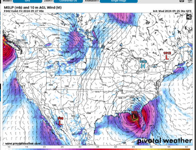
6Z GFS track is consistent with the centerline of the NHC track and shows the northeast quadrant of a Cat 3 pushing into the concave area of coastline of the Big Bend region, could be quite a storm surge…

IMG_2226.jpeg
 
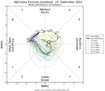
Screenshot 2024-09-25 at 10.09.16 AM.jpeg
Hurricane Helene's got a lot going for it; read NHC's take. Also, it's heading to the Gulf Coast into the area historically well-correlated with the (latest) MJO rotation into phase 8 (see Australian Bureau of Meteorology figure above.) The wind-field's progged to be large. So, this doesn't appear to be a (more chasable) smaller & mighty fist or punch, like Michael. Rather, a large, open-handed (Will Smith -styled) blow appears in the offing. Accordingly, the substantial storm surge & flooding rains will inundate widespread areas, while wind damage with downed power poles & trees will present far-reaching obstacles to die-hard chasers as the storm quickly pushes inland. If you're there already, good for you. Otherwise...
 
Last edited:
The newest surge estimates make much of the Big Bend coast a no-go for chasing in any capacity. Surge forecast of 20 feet leaves very little room for error for pretty much anywhere on the right side of the eyewall. Crawfordville’s elevation is 30 feet, but has nothing in the way of substantial shelter that I’ve been able to find and nothing above ground level. Just too much of a risk, to a vehicle especially, to go down there for what is going to mostly be a dusk-and-afterward event. Risk-reward calculation just isn’t favorable for a chaser. On top of this, there are reports that some of the county law enforcement there is stridently anti-chaser with several chasers being threatened with arrest during Debby for breaking curfew.

If this were a daytime event, I would definitely have chased and would be heading to Tallahassee as my target. It’s out of the surge and there are more video subjects. But nighttime just doesn’t yield good enough video to make that trip worth it.
 
I agree...I'd target Tallahassee for a daytime event too, if I still lived in Tampa, FL. Also, here's something kinda interesting this morning.
With low shear & good upper divergence, Helene's traveling over the Loop current almost 1/2 mile deep with surface water-temps 84 to over 88 degrees F. But, NHC has busted down the forecast max-winds substantially since last night: 130 mph lowered to 115 mph. Flights have found competing, concentric eyewalls, 16 and 32 nautical miles across. That's the reason, but still a major hurricane in the forecast, Cat. 3 not 4.
 
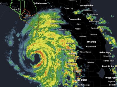
So, the eye has consolidated nicely and contracted. Meanwhile, the intensity has risen almost 35 mph since sunrise. It could make that lower Category 4 designation before landfall. NHC advised that, "Hurricane-force winds extend outward up to 60 miles from the center & tropical-storm-force winds extend outward up to 310 miles." I'd say that makes it one of the bigger ones! From Tampa radar below ~ 5:25 p.m. EST. Screenshot 2024-09-26 at 4.24.50 PM.jpeg
 
Last edited:
It's been reported that there is a large law enforcement operation, including county officers and state troopers, in progress to intercept and arrest any chasers who are on the roads in Perry, Florida.
 
Surprised to see some business signage apparently still intact in Perry per chaser videos/photos. Those usually are some of the first things to go in a hurricane, most are blown out after the first eyewall pass in even a Cat 1/2. Highest gust on an ASOS/AWOS was 99mph at the Perry station.
 
It's been reported that there is a large law enforcement operation, including county officers and state troopers, in progress to intercept and arrest any chasers who are on the roads in Perry, Florida.

looks like chasers in Perry have all been forced into the hotels by the LEO operation.

Now see this is why I always say hurricane chasing logistics perplex me. Obviously people do it, but it seems intractable to me. And what would have happened if the hotels were evacuated? What if the chasers had no reservations there, were they just hanging out in the lobby? Dan, any details or source links you can share about this situation?

Matthew Cappucci included in his book a chapter on chasing his first hurricane. He had reservations at a hotel in Florida that turned out to be closed for evacuation. He ended up spending a miserable night in a public shelter.
 
That situation in Perry is really out of the ordinary, at least in my experience. That county is well known for being rabidly anti-chaser. Though as Chris Collura points out in his writeup, it’s not unheard of. I only encountered this once after Isabel in North Carolina after the storm on our way back. We were allowed to keep going as long as we didn’t stick around. No such issues at all for Frances, Ivan, Rita, Ernesto or Michael.

I don’t have a lot of experience with hotels as I only used them the days before Frances made landfall. In that case, the staff evacuated but let already-checked-in guests stay (the only ones there were chasers and media).

In Perry, the hotels were still open for chasers and media to stay at though it’s likely the staff was gone. Anyone staying there just needed to be checked in long before the staff left.

I think you definitely would need to be prepared to spend a night or two in your vehicle though just by nature of this type of chase. Pillows, blanket, air mattress if you have a van or suv. And maybe book and check into multiple hotels in different locations to allow for repositioning.

Word was getting around about the LEO issues pretty early on, which would have alerted most on there way there to what was happening and allowed adjusting. Some who didn’t already have a room were able to stay with those who offered some space to sleep in theirs.

I also believe that in larger urban areas and farther-inland towns this is much less likely to happen. It’s almost always happening for higher-risk places like barrier islands, but those are normally no-go areas anyway.
 
Back
Top