US Chase Map Project

I am looking at this very carefully, and could it be that some of that tree data is incorrect? Is that possible that there are so few trees in SC LA? How about right around Lake Tahoe? OH and MI, too. I have been to all those places, and maybe the green-shaded areas are only meant to depict the very thickest of forest canopies. There are some pretty wooded areas of E KS, too.
 
I am looking at this very carefully, and could it be that some of that tree data is incorrect? Is that possible that there are so few trees in SC LA? How about right around Lake Tahoe? OH and MI, too. I have been to all those places, and maybe the green-shaded areas are only meant to depict the very thickest of forest canopies. There are some pretty wooded areas of E KS, too.
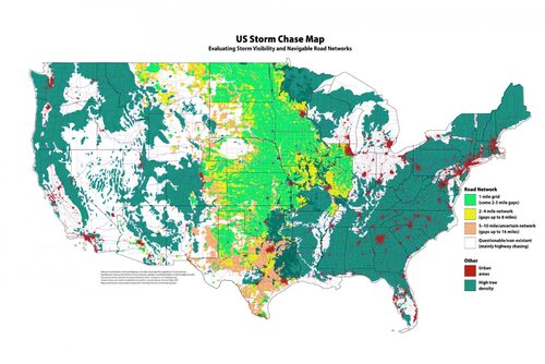
So it looks like the green color represents "aboveground woody biomass" and the threshold I used for the map is about 75 tons per hectare. Below that was removed, which explains cases such as eastern Kansas and southern Louisiana. However, if I zoom in on a very high resolution image of the map, you can notice some green specks.

The density of trees/biomass across the Pacific Northwest is so high that it seems to have been removed from the map. I may amend this at some point, but for the vast majority of areas that chasers would target (Plains/Midwest), I feel this map is fairly representative. Although an area like eastern Kansas has some wooded areas, it's nowhere near as obstructive as areas around the Ozarks, for example.

More information:
Forest cover by state and territory in the United States - Wikipedia
 
Chased yesterday in SW Wisconsin, will probably be my last time chasing there lol. Terrain reminds me of Southern MS (should have known better as this is where I usually go for eagles, SE of La Crosse). Hopefully these next few days will offer up setups in more chase friendly terrain. I had a view of the storm yesterday, but could never see anything due to the trees. Probably chasing shelf clouds in IL today. Also agree with Andy, there is no real planning for these types of events and this is just typical summer weather for this area lol.
 
I saved this when it was posted in 2015. Seems like a good time to share it again as people may be considering venturing a little further North over the next few daysView attachment 22108

Not to go OT, but I’m surprised eastern KS is shown in light green. I recall most everything east of a line from Salina to Wichita as being pretty bad for chasing, and I have historically avoided it. I kind of think of KS as being pretty much a copy of OK as far as staying west of I-35.
 
Kansas is accurate. Flint Hills roads are a little spread out, but the map shows it. Southeast Kansas has more trees and hills, but it's not continuous. Agree no dark green there. Roads are actually quite common in southeast Kansas. However this year some construction has one-lane clusters in spots. If you get a red light, hope you don't miss anything - or worse get munched!

Kentucky, Tennessee and Alabama are mostly accurate. White spots are indeed more open with fewer trees. Far western tip of Kentucky is awful though. South-central Kentucky does have open spots as shown. Ditto either side of the Cumberland Plateau in Tenn. North Alabama benefits from a locally wider Tennessee River Valley. Northeast Alabama's Sand Mountain is more a plateau and somewhat cleared for agriculture.

North of Indianapolis and Dayton is good chasing (flat agriculture fewer trees) despite the roads a bit more spread out. Main theme I'll take white over dark green any day of the year! My chasing style (not extreme) roads are less important. However I can't have forests.

I really like and trust this map if I'm considering locations with where I've not been before.
 
I saved this when it was posted in 2015. Seems like a good time to share it again as people may be considering venturing a little further North over the next few days

Just FYI, Todd, after discovering discrepancies in which my previous post made me sound like a total idiot, I discovered that you had posted a different version of the map that Jeremy has in his original post.
 
Not to go OT, but I’m surprised eastern KS is shown in light green. I recall most everything east of a line from Salina to Wichita as being pretty bad for chasing, and I have historically avoided it. I kind of think of KS as being pretty much a copy of OK as far as staying west of I-35.
I agree with that part of the map and find that E KS and E OK are worlds apart. I avoid the latter like the plague in all but the most desperate of times, whereas there are only a couple isolated pockets in KS that are worth that kind of avoidance. Roads can be an issue in the Flint Hills, for sure, but it's more like a toned down Cherry Co. situation: you'll still see the tornado, it just might be from 10 miles away. The two legit trouble spots I've run into are (1) Manhattan-Junction City northward for about 20 miles, and (2) +/- 20 miles either side of I-70 from Topeka to KC. Even then, those just barely rise to the level of how awful the average spot in E OK is!
 
I agree with that part of the map and find that E KS and E OK are worlds apart. I avoid the latter like the plague in all but the most desperate of times, whereas there are only a couple isolated pockets in KS that are worth that kind of avoidance. Roads can be an issue in the Flint Hills, for sure, but it's more like a toned down Cherry Co. situation: you'll still see the tornado, it just might be from 10 miles away. The two legit trouble spots I've run into are (1) Manhattan-Junction City northward for about 20 miles, and (2) +/- 20 miles either side of I-70 from Topeka to KC. Even then, those just barely rise to the level of how awful the average spot in E OK is!

Well in that case, I feel stupid for having avoided E KS for all these years! I don't think I missed any significant events by doing so, except maybe Lawrence in 2019, but I stayed away from that more because of the metro area. I will definitely consider E KS a part of my range going forward.

I guess my bias against E KS is a function of my very first years in chasing, when I was with one of the original tour groups, Marty Feely's Whirlwind Tours, in 1996, 1997 and 1998. He always had a rule of thumb of staying west of I-35. My impressions of E KS were probably also skewed by how it becomes less favorable just east of Wichita (see stripe of orange on the map), so in my mind that always marked my eastern limit. I guess I never really had much occasion to venture there on any of my chase vacations, nothing was ever compelling enough (or there was something better further west).

To be honest, there are a number of areas that kind of suck in W KS too, such as up around I-70 near Quinter, areas around Scott City, Leoti, Jetmore, etc. Paved roads can be 10+ miles apart up that way, leaving huge areas with no roads to get to a NE or SE moving supercell... Not sure whether the map differentiates between paved and dirt roads, there are plenty of dirt roads in the area mentioned but many are not very good quality. Especially in 2021, on a few chase days in the area they were wet and muddy from previous days' storms.
 
I have chased east of I-35 in Kansas a few times and I can confirm that, although the roads occasionally don't cooperate, which is pretty similar to parts of C/W KS west of I-135, E KS has some really pretty chase terrain in it and I see no reason to skip on it unless you have the absolute highest expectations of chase terrain, in which case you better stay west of the Llano Estacado crease or in E ND/SD, because those are the only areas that would meet such high expectations.
 
I have chased east of I-35 in Kansas a few times and I can confirm that, although the roads occasionally don't cooperate, which is pretty similar to parts of C/W KS west of I-135, E KS has some really pretty chase terrain in it and I see no reason to skip on it unless you have the absolute highest expectations of chase terrain, in which case you better stay west of the Llano Estacado crease or in E ND/SD, because those are the only areas that would meet such high expectations.

Agreed, that’s probably the best way to look at it, just about every region I’ve always thought of as generally “good” has bad spots, except the ones you listed (of which I only have experience with the TX region you mentioned, and agree it’s the best; I’ve only been in W SD and never in ND at all, so I can’t compare...)
 
I personally love chasing Eastern/Northeast Kansas. I just have horrible luck there. Yea the road network isn't the greatest in the Flint Hills, but the views are great for visibility and there are some decent storms to be had in the last several years. The day after Mangum in 2019 would have been much higher quality imo if the roads in much of KS hadn't been flooded. Caused a lot of issues with chasing.
 
The challenge of the eastern half of Kansas (aside from lack of roads in the Flint Hills and hoping you can find a place to stop on top of a hill if you want to see anything) would be the river crossings. I grew up in NE OK, but also spent a good deal of time in SE KS and know both areas very well. Both the Neosho and Verdigris rivers can present challenges with their propensity for flooding, particularly if there's been a good deal of rain recently. That's true in both states, and contrary to popular belief, there are some chaseable areas in NE OK, particularly along the US-69 and US-60 corridors.

The US-412 corridor between Catoosa and Chouteau also isn't bad as long as you can deal with the aforementioned Neosho and Verdigris rivers. I'm still kicking myself for not chasing whatever day that was in 2018 where there were tornadoes near Chouteau. I let the fact that it rained late into the morning dissuade me from making the drive into some very familiar territory where I can draw a map from memory.
 
Back
Top