US Chase Map Project

@JamesCaruso Thanks for the feedback, James.

@joel ewing Thanks, Joel. The extent of that sandhills road gap was something I was interested in too. I had some nice, structure views of a tornado-warned supercell out there south of Arthur last year. But it was definitely a sandhills-style famine & feast scenario of being mostly too far out for consistent, clear views of the base, vs. timing an escape down the only road to dash out of the way. I hope Nebraska and everywhere else treat you well this year.
 
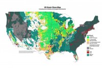
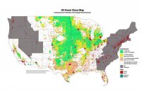
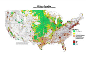
Map Update - 15 May 2015

I've finished evaluating road networks for Arkansas, Louisiana, Mississippi, Alabama, Tennessee, Kentucky, Indiana, Ohio, Michigan, and Wisconsin to wrap up the central US area. I also worked up California and Florida for road options at the tornado hors d'oeuvres they serve up. To help distinguish things better, I added a gray tone to states that haven't been evaluated yet.

US Storm Chase Map - with forested areas
US_ChaseMap_20150515A.jpg

US Storm Chase Map - without forested areas
US_ChaseMap_20150515B.jpg
 
Jeremy, thanks for all the hard work on developing this resource. I "discovered" the sandhills of NE last year and to say the least it's a challenge to chase. To plus it, it would be cool to combine these graphics with the Verizon 4G and NOAA NEXRAD radar coverage maps. Voila you have "prime" stormchasing/chaser convergence territory.
 
Jeremy, thanks for all the hard work on developing this resource. I "discovered" the sandhills of NE last year and to say the least it's a challenge to chase. To plus it, it would be cool to combine these graphics with the Verizon 4G and NOAA NEXRAD radar coverage maps. Voila you have "prime" stormchasing/chaser convergence territory.

If you were going to overlay cell coverage, You'd almost have to include AT&T as well as many chasers use them. Some use both. One color for Verizon, one for AT&T, another where they both cover. The southern plains tends to be dominated by AT&T, although Verizon has made a lot of progress in recent years.
 
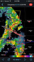
@Jeff Hawkins — Thinking along the lines of that prime convergence territory...It's been pretty telling this afternoon, watching all the Spotter Network icons jamming up against Hwy 26 while the storms enjoy some breathing room on their way north : )

View attachment 8183
I got home late from work and missed the show online unfortunately, but have been watching the goings on since. That looks a bit crowded. I shifted my vacation back 2 weeks otherwise I'd probably be there too. Some things are worth missing : )
 
I'm not sure if this has been mentioned because there's too much to read for my pea brain, but is there going to be any state zoomed maps depicting which county roads are paved and which aren't? I think on years like this year, it's important to know what roads are paved in the south plains due to all the rain we've received.
 
I use a Garmin Nuvi 7" LMT and it is rarely misinformed about roads that are paved and roads that are dirt as per the road graphic depiction (lighter-dirt vs darker-paved). The biggest problem is many of the [dirt] roads it indicates are in actuality private ranch roads. I can not imagine chasing without my Garmin. It did a great job Saturday getting me from Magnum to Mountain Park in time to get in front of the Tipton cell (where down and over on 62 was not a possibility due to hail potential) so it routed me through the woods, as straight as possible, all paved roads

Plus, it is possible to add a topographic map when needed to look for higher terrain with road access.
 
Last edited:
I'm not sure if this has been mentioned because there's too much to read for my pea brain, but is there going to be any state zoomed maps depicting which county roads are paved and which aren't? I think on years like this year, it's important to know what roads are paved in the south plains due to all the rain we've received.

Especially in the eastern Panhandle down through Childress as well as the far western OK counties. There were a lot of impassable mud pits down there on Saturday.
 
Awesome map, definitely worth a bump. I recall finding the early version of this map online a while back, but now the update that includes more of the Mississippi Valley and Ohio Valley makes this just about complete for most chasing.

I chased in northwestern Ohio in August and I must say, it reminded me a lot of Iowa, visually. An excellent road network, great visibility and an array of wind farms. Perhaps one of the more underrated places to chase in the country...
 
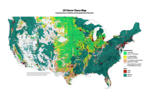
So this update is kind of late for the 2017 season, but wanted to get it out there anyway. This adds info for the remainder of the western and eastern US. I also got permission from the Reddit user WestCoastBestCoast94 to include the road image he generated, so that underlayer has been included....mostly shows up as gray patchiness at these resolutions. I've exported 3840px wide versions, but they're 4MB each, and not sure if the site will let me upload those.

Versions with and without tree canopy below:

US_ChaseMap_20170529withForest_1920px.jpg

US_ChaseMap_20170529_1920px.jpg
 
Great work, Jeremy. I've been a huge fan of this map and it's awesome to see it completed, coast to coast. I keep a hard copy in my car for quick reference. Sometimes if I'm debating on chase targets, I will assess road networks and visibility as important considerations, making this map we useful. Even though I've traveled the Plains quite extensively over the last few years, I still reference this map. (Especially when deviating east of the Plains.)

Having grown up in the Northeast, it's also nice to see New York mapped. I knew that parts of upstate New York had relatively chaseable areas, and now that has been objectively evaluated here. Despite some hill and tree issues, I've also chased in North Carolina a few times and this map confirms the not-so-awful road networks there.
 
Thanks for the feedback Quincy, I'm glad it's been useful! I'd probably hedge on calling it objective...it's based on a visual assessment of the road network, so there's a fair amount of subjectivity in there. At a variety of points, I'm positive people could find things that aren't spot on. Texas was questionable in a lot of places, because of how often the road grid there is rotated 45°. At available resolution I couldn't visually tell if those networks were truly gridded or not, so they got knocked down in quality due to uncertainty. Mainly, I tried to err on the side of pessimism if I couldn't tell for sure how well gridded the network was.

Despite all that, I've been pretty satisfied with how it's held up in areas where I've chased. The area in NW Oklahoma/Barber County Kansas definitely checks out as sketchy; some tough road choices too in the less networked area in N Texas along the Red River; but then some pretty decent zones in the Mississippi flood plain. The map gave me confidence with a setup that looked like it could produce in that flood plain & I caught a tornado near Grady, Arkansas last year because of it. Some day, North Dakota shall call, and I will answer.
 
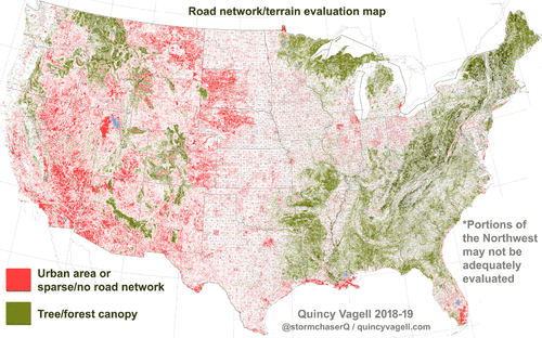
Reviving an old, but very useful thread and adding in a map of my own, inspired by @Jeremy Perez.

I took a base map and overlaid it with a road network map. To come up with the road network, I actually filled in the space between roads as red. This happens to show how sparse a road network may be, like across central Nebraska, but also works to show where the network is so tight that it's an urban area/concrete jungle of sorts. It was easy to "remove" the roads if there was a consistent, but not tightly spaced road network, as you would expect to see in a larger city.

From there, I used a map of the forest canopy to show where most of the relatively tall trees are. The resolution isn't the greatest, but it gives you a general idea of what's going on. Something is wrong with the colors in the Northwest. I think it is terrain related, as I don't believe there should be so much whitespace across western OR/WA.
evaluation_3000px.gif
 
Back
Top