Tri-State Tornado 90th Anniversary

Joined
May 1, 2004
Messages
3,417
Location
Springfield, IL
Today is the 90th anniversary of the March 18, 1925 Tri-State tornado. That tornado is practically mythical. Few events come to close to it in its many records. I thought it would be interesting to see how the damage path compared to other notable tornadoes and record breakers that are still fresh in our memories. Here's an infographic I made for Storm Assist:

full


I wonder when we'll see an even greater tornado, and if we're prepared for its impacts. I certainly wouldn't want to chase it. There was nothing good about the Tri-State. If it occurred again it would be nearly impossible to chase and see, leaving only death and misery in its wake.
 
This event was one of the big reasons I chose to move to St. Louis instead of the Great Plains. It and much of the local severe weather climatology convinced me that this was a fairly 'untapped' tornado region in terms of chaser coverage. There will be another tornado like this eventually. I can only hope that advances in warnings and preparedness will prevent the same kind of death toll.

Today's 90th anniversary talks in Carterville were interesting. My favorites were John Hart's (lead SPC forecaster) estimate on what the Day 1 & 2 outlooks might have been for this event, and the detailed study that was done to plot the damage path using interviews with locals. That paper is viewable here:

http://www.ejssm.org/ojs/index.php/ejssm/article/viewFile/109/89

This study essentially confirmed that this was indeed a single continuous tornado (not a family of tornadoes from a cyclic supercell), aside from some inconclusive breaks in recorded damage at the beginning of the track.
 
Love that graphic, Skip. It hits on all the major stats, and the various tracks with the legend for scale are pretty sweet. It makes me want a listing of all the major tornadoes with the sizes and lengths of their tracks included for visual comparison. I can't imagine following or trying to keep up with a tornado for 219 miles. It's mind blowing.
 
I really like the graphic; I saw it passed around on Facebook. Out of curiosity, how did you come up with the path outline for the Tri-State tornado? Is there a historical source for the width as a function of position along track, or was there artistic license?
 
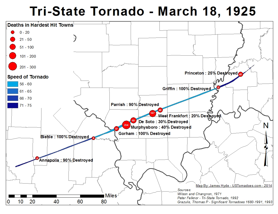
It's based off this plot, which lists it sources:
Tri_State_Path1.jpg


I did a sanity check on the track width to make sure the majority of it fell within the cited .75 - 1.0 mile average width. I'm sure it's a real rough guess, but any reconstruction from that time period is going to be. The other tracks should be much more accurate.
 
Back
Top