-
While Stormtrack has discontinued its hosting of SpotterNetwork support on the forums, keep in mind that support for SpotterNetwork issues is available by emailing [email protected].
You are using an out of date browser. It may not display this or other websites correctly.
You should upgrade or use an alternative browser.
You should upgrade or use an alternative browser.
Southwest Monsoon 2019 Discussion
- Thread starter Warren Faidley
- Start date
Mike Olbinski
EF0
Interesting.
I never thought about dust storms and being related to monsoon season.
----------
Not really related, but I'm hoping for some good monsoon-season thunder/rain storms in my part of Colorado. this year..
How did you think they happened before?
By windstorms. (the type where its 'just wind', no actual storm, the sky can even be clear .. happens here in CO, though its more likely to happen in winter/spring) .. I was simply assuming you get them down in AZ & that was what caused the dust storms.Mike Olbinski said:How did you think they happened before?
----
One thing I like about this site is you end up learning new things
Warren Faidley
Supporter
Very impressive Sonoran rh surge last night and this morning in SE Arizona. Weak 500mb, SW flow, and not so impressive rh depth in central Arizona looks marginal for strong storms and outflows moving westward towards Phoenix. I would suspect Saturday onward, especially Sunday + looking good for all monsoon wx threats into central Arizona. It will interesting to see if the rain in SE Arizona settles the dust in advance of better instability, thus limiting the odds of a mega-dust storm.
Edit: Interesting to see the 1-day soil moisture content change. Not sure how this will effect the intensity of dust storms but it certainly cannot help. The areas to the south and west of Phoenix are still very dry so there are still possibilities.
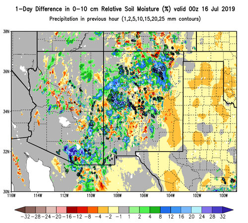
Edit: Interesting to see the 1-day soil moisture content change. Not sure how this will effect the intensity of dust storms but it certainly cannot help. The areas to the south and west of Phoenix are still very dry so there are still possibilities.

Last edited:
Tony Laubach
EF5
Hoping to snag a few days in mid-August to head down that way... I've managed three trips over the last ten years, so I'm due for one. LOVE LOVE LOVE doing lightning photography, and was hooked after my first trip down there in 2007, which was a prolific trip for me lightning-wise. The last couple trips were a bit less filling, but fun none-the-less (and not that Phoenix isn't a plethora of things to do to pass the time - inside of course cause f*%$ that heat LOL).
Will be in Colorado this weekend, hoping maybe I will get an evening early next week to snag a shot or two
Will be in Colorado this weekend, hoping maybe I will get an evening early next week to snag a shot or two
Mike Olbinski
EF0
Very impressive Sonoran rh surge last night and this morning in SE Arizona. Weak 500mb, SW flow, and not so impressive rh depth in central Arizona looks marginal for strong storms and outflows moving westward towards Phoenix. I would suspect Saturday onward, especially Sunday + looking good for all monsoon wx threats into central Arizona. It will interesting to see if the rain in SE Arizona settles the dust in advance of better instability, thus limiting the odds of a mega-dust storm.
Don't think SE AZ affects central AZ's dust too much. Phoenix and the potential for an epic haboob are mostly dependent on dust from around Picacho Peak and northward. One rain storm there so far, and not over a big area. Maricopa and eastward are big dust producers as well because of all the farms. I haven't seen anything yet that would limit a huge dust storm once we get some strong storms on the north side of Tucson pushing N/NW or once we see some of that NE flow off the Rim push some monsters through Phoenix.
Looking like great chances next week with typical SE flow. Hopefully a good monster.
John Farley
Supporter
Warren Faidley
Supporter
Don't think SE AZ affects central AZ's dust too much. Phoenix and the potential for an epic haboob are mostly dependent on dust from around Picacho Peak and northward. One rain storm there so far, and not over a big area. Maricopa and eastward are big dust producers as well because of all the farms. I haven't seen anything yet that would limit a huge dust storm once we get some strong storms on the north side of Tucson pushing N/NW or once we see some of that NE flow off the Rim push some monsters through Phoenix.
Looking like great chances next week with typical SE flow. Hopefully a good monster.
Yes, very true. Still a very good chance of a monster if the timing is right. 500mb winds start to look really good on Sunday. My best guess is Sunday or Monday for a big event. Could be Saturday if the upper levels increase from the east / se.
Mike Olbinski
EF0
Yes, very true. Still a very good chance of a monster if the timing is right. 500mb winds start to look really good on Sunday. My best guess is Sunday or Monday for a big event. Could be Saturday if the upper levels increase from the east / se.
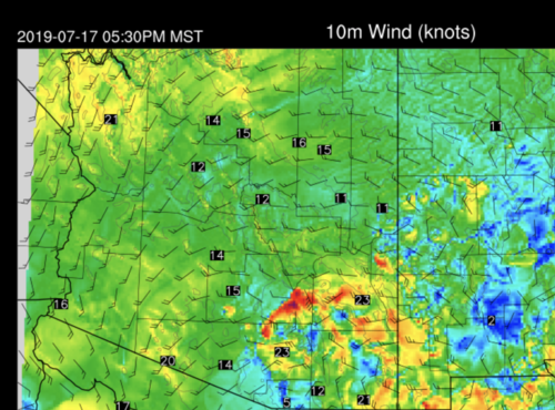
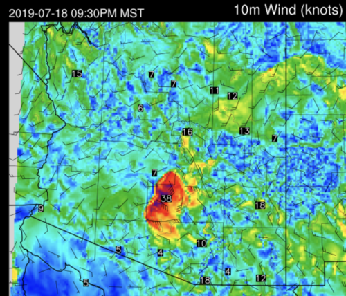
Latest 15Z RR showing a boundary tonight moving up the 10 with some storms behind it, so we'll see if it plays out.
Attachments
Mike Olbinski
EF0
Warren Faidley
Supporter
Right now the CAMS are all holding off precipitation today for some reason, or limiting it to the Tucson area. Cloud cover might be mucking up the forecast. In reality, any day has potential, as you know!
Mike Olbinski
EF0
Right now the CAMS are all holding off precipitation today for some reason, or limiting it to the Tucson area. Cloud cover might be mucking up the forecast. In reality, any day has potential, as you know!
Yup! Although the 15z RR has a lot of convection today, and it's pretty accurate. I dunno, we will see. Looks pretty clear southeast of Tucson right now. Bubbling over the mountains already, one cell by Sierra Vista.
Mike Olbinski
EF0
Yup! Although the 15z RR has a lot of convection today, and it's pretty accurate. I dunno, we will see. Looks pretty clear southeast of Tucson right now. Bubbling over the mountains already, one cell by Sierra Vista.
*usually* pretty accurate is what I meant to say haha. I'm tired and want to head south to Tucson but looking a bit weak out there right now.
Warren Faidley
Supporter
RH dropped to 21%. Some serious moisture issues this year.
Warren Faidley
Supporter
Well I guess if you could issue a "High Risk" of dust storms, it would be today. Things are coming together today for what appears to be a big event. 500mb winds are exceptionally supportive of both venting and moving storms towards the west / northwest. Earlier satellite images appeared to show some gravity waves over the region from last night's complex in Sonora, moving north / northwest. The easterly flow should provide decent shear for monsoon-type storms, e.g, 20-30 kts. which might keep the outflow machine going as it moves west towards Phoenix and Casa Grande. Tucson's rh is holding, well in line with previous big events. The CAMS agree on forming a line of storms east of Phoenix by late afternoon. The skies have cleared and the launch pad is ready.
Similar threads
- Replies
- 19
- Views
- 3K
- Replies
- 21
- Views
- 7K

