Southwest Monsoon 2019 Discussion

Warren Faidley

Supporter
Joined
May 7, 2006
Messages
2,311
Location
Mos Isley Space Port
There could be a "perfect storm" situation setting up for a mega-dust storm this weekend near Phoenix and surrounding areas.

1: Delay of monsoon. The monsoon typically starts during the first week in July. This extra heating time has removed a substantial about of moisture from the 0-10 cm soil content, especially east of the Phoenix area. (See chart below).

2: The initial onset of higher RH figures (55ºF+ dp's) will likely come in 1-2 day surge, preventing soil from being moistened over a period of time. The July 6, 2011 mega-dust storm had 35% relative humidity at noon in Tucson, holding at 31% at 3:00 pm.

3: There is likely more dead, vegetation particles on the desert surface after two hard freezes this winter. This was a contributing factor to the big dust storm in 2011 according to research involving particulates recovered during the storm.

The wild card will be how the storms form and move. In 2011 they formed in severe (broken) lines near Tucson northward and the outflows were able to consolidate as the storms moved west / northwest. The models currently show typical southeast monsoon flow at 500mb and 700mb, slowly moving storms in a favorable n/nw direction.
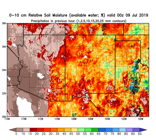

19047
 
Last edited:
I can't f-ing wait! Colorado monsoon is just a hair above traditional storm season in my "let's get out there" scale. Give me some dry lightning!!
 
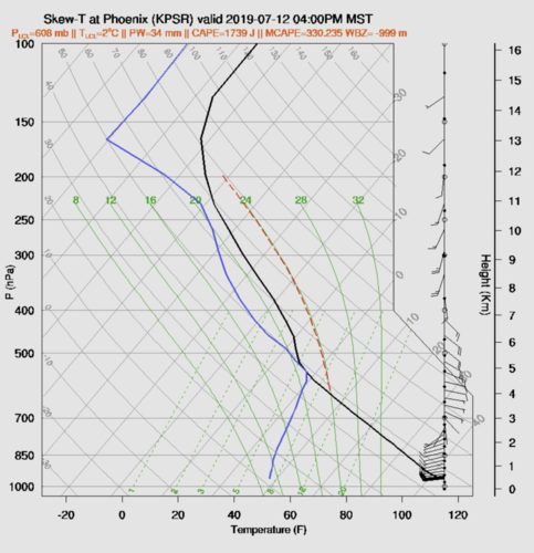
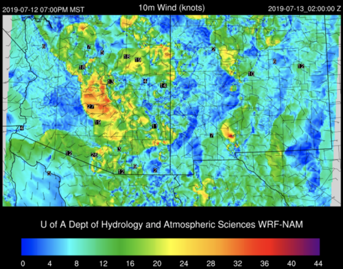
Thanks for getting that discussion started, Warren. The UofA WRF models only have the GFS CAM in range so far, but it hints at Friday possibly being a day to watch for a starter round. The 4PM PHX sounding shows steering flow could nudge incipient storms westward/northwestward into the valleys with anvils knocked out of the way, northeastward. Surface convergence could also be aided with westerly surface winds if that panned out.
19049

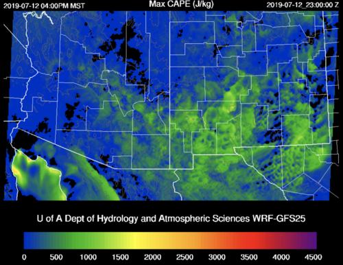
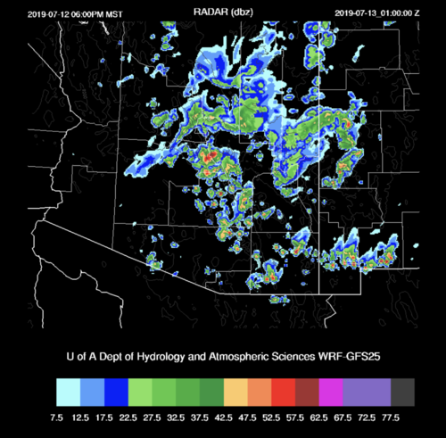
CAPE doesn't look all that great on the surface plot, but the reflectivity model shows convection getting off at least one round from that down in the desert.
19050

19051

With the soil nice and crispy like you noted, that could be a fun I-8 haboob surf. As usual, need to see if that trends, and if it shows up on the NAM & RR, or if it moves off to the weekend or later.

Might have to make a trip down off the rim...
 
Last edited:
Yes. NWS Phoenix also mentioned Friday and/or Saturday (in addition to Sunday). I'm not sure if the rh is going to be elevated enough to produce and support a line of high-topped, severe cells needed to create apocalyptic dust. If they only dampen the soil, it really reduces the odds of a big show. Just hope people will keep the hell off the freeways when these things come ripping.
 
Warren - around Phoenix the deserts are covered with thick grass - a couple of invasive species, which is why our fire situation is precarious. I don't know about the situation in your area. I wonder if that grass will hold down a lot of the dust.

I suspect we'll get a chance to find out.
 
Yea, I don't think the grass will do much to prevent a big dust storm. During past storms, most of the particles were picked up east and southeast of Phoenix. I did a minor survey last week near Casa Grande and Eloy, and it was dry as a bone. We will know soon enough!
 
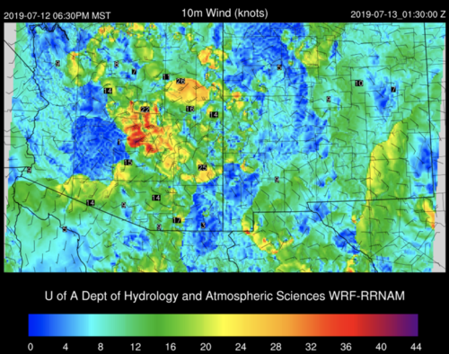
For Friday, 12Z WRF-NAM and WRF-RR both favor the idea of outflow dropping off the Mazatzals from the east. Not the primo dust source. The RR does show an option for weaker outflow moving up from the south, off weaker convection. Moisture isn’t great, especially further west, so storms may not propagate and reinforce the gust front. The wind forecast still looks encouraging though.
19074 . 19075

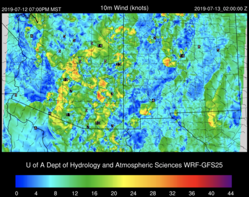
12Z WRF-GFS25 is more optimistic with moisture content in the southern deserts and firing storms in Pinal County, which would be a better dust source, although with weaker winds for reasons I haven't worked out.
19076

I don’t chase these as much as the desert dwellers, and I don’t have time to see how well the models are initializing. But it seems encouraging enough to head down—if anything, to work on getting better with haboob tactics, and maybe get something unexpected.
 
Saturday and Sunday have chances too.

I will say, storms from the Mogollon Rim with strong outflow going through Phoenix towards Maricopa is what caused July 9th last year :) So it's not bad, but you do need pretty strong storms for that to happen.
 
Hoping by tonight to have a better idea whether to store up energy for Sat/Sun instead of Friday...

Mike Leuthold also just posted discussion for today/tomorrow and this overall start to the monsoon pattern:

To anyone who hasn't ventured to his blog, he provide a great resource for AZ monsoon meteorology. Not to forget, the models he maintains here:
 
Still counting on Saturday or more-so Sunday as the possible big days. The hardest thing to predict are often the debris clouds left over from local activity or a decaying, Sonorian MCS. Such cloud cover kills the CAPE. Friday has potential only because the dust bed is undisturbed and any organized outflows could easily lift the fine particles. The epic dust storms really need the combination of elements as noted above.

Edit: Having checked the 18z RAP, there is a hint of a rapid, surface moisture surge tomorrow at peak heating. So tomorrow would be in play if the rh holds.
 
Last edited:
Really boring monsoon so far. One of the latest I can remember -- rh wise.

The low rh and overall lack of energy and supporting upper-level flow has really put a monkey wrench in the progress. The areas between Tucson and Phoenix remain bone dry (or drying out from light showers). The 110ºF+ temps are really frying the small plants, making an even more dramatic dust storm possible. Phoenix forecasting 114ºF tomorrow (7-16). Looking at Wednesday or Thursday as the next potential targets as a surge of rh and gravity waves / eastern flow disturbances could load the gun. Still possible to have a world-class dust storm in the next week.
 
Last edited:
Interesting.
I never thought about dust storms and being related to monsoon season.

----------
Not really related, but I'm hoping for some good monsoon-season thunder/rain storms in my part of Colorado. this year..
 
Interesting.
I never thought about dust storms and being related to monsoon season.

----------
Not really related, but I'm hoping for some good monsoon-season thunder/rain storms in my part of Colorado. this year..

How did you think they happened before?
 
Mike Olbinski said:
How did you think they happened before?
By windstorms. (the type where its 'just wind', no actual storm, the sky can even be clear .. happens here in CO, though its more likely to happen in winter/spring) .. I was simply assuming you get them down in AZ & that was what caused the dust storms.

----
One thing I like about this site is you end up learning new things :)
 
Very impressive Sonoran rh surge last night and this morning in SE Arizona. Weak 500mb, SW flow, and not so impressive rh depth in central Arizona looks marginal for strong storms and outflows moving westward towards Phoenix. I would suspect Saturday onward, especially Sunday + looking good for all monsoon wx threats into central Arizona. It will interesting to see if the rain in SE Arizona settles the dust in advance of better instability, thus limiting the odds of a mega-dust storm.

Edit: Interesting to see the 1-day soil moisture content change. Not sure how this will effect the intensity of dust storms but it certainly cannot help. The areas to the south and west of Phoenix are still very dry so there are still possibilities.

19111
 
Last edited:
Hoping to snag a few days in mid-August to head down that way... I've managed three trips over the last ten years, so I'm due for one. LOVE LOVE LOVE doing lightning photography, and was hooked after my first trip down there in 2007, which was a prolific trip for me lightning-wise. The last couple trips were a bit less filling, but fun none-the-less (and not that Phoenix isn't a plethora of things to do to pass the time - inside of course cause f*%$ that heat LOL).

Will be in Colorado this weekend, hoping maybe I will get an evening early next week to snag a shot or two :)
 
Very impressive Sonoran rh surge last night and this morning in SE Arizona. Weak 500mb, SW flow, and not so impressive rh depth in central Arizona looks marginal for strong storms and outflows moving westward towards Phoenix. I would suspect Saturday onward, especially Sunday + looking good for all monsoon wx threats into central Arizona. It will interesting to see if the rain in SE Arizona settles the dust in advance of better instability, thus limiting the odds of a mega-dust storm.

Don't think SE AZ affects central AZ's dust too much. Phoenix and the potential for an epic haboob are mostly dependent on dust from around Picacho Peak and northward. One rain storm there so far, and not over a big area. Maricopa and eastward are big dust producers as well because of all the farms. I haven't seen anything yet that would limit a huge dust storm once we get some strong storms on the north side of Tucson pushing N/NW or once we see some of that NE flow off the Rim push some monsters through Phoenix.

Looking like great chances next week with typical SE flow. Hopefully a good monster.
 
Although as you can see on Warren's map, parts of New Mexico have had their moments, it has been real anemic in southern Colorado so far. But I did manage to get one decent lightning shot last night looking southwest from Pagosa Springs.

IMG_8003-cr-e.jpg
 
Don't think SE AZ affects central AZ's dust too much. Phoenix and the potential for an epic haboob are mostly dependent on dust from around Picacho Peak and northward. One rain storm there so far, and not over a big area. Maricopa and eastward are big dust producers as well because of all the farms. I haven't seen anything yet that would limit a huge dust storm once we get some strong storms on the north side of Tucson pushing N/NW or once we see some of that NE flow off the Rim push some monsters through Phoenix.

Looking like great chances next week with typical SE flow. Hopefully a good monster.

Yes, very true. Still a very good chance of a monster if the timing is right. 500mb winds start to look really good on Sunday. My best guess is Sunday or Monday for a big event. Could be Saturday if the upper levels increase from the east / se.
 
Yes, very true. Still a very good chance of a monster if the timing is right. 500mb winds start to look really good on Sunday. My best guess is Sunday or Monday for a big event. Could be Saturday if the upper levels increase from the east / se.


Latest 15Z RR showing a boundary tonight moving up the 10 with some storms behind it, so we'll see if it plays out.
 

Attachments

  • Screen Shot 2019-07-17 at 10.23.38 AM.png
    Screen Shot 2019-07-17 at 10.23.38 AM.png
    1.9 MB · Views: 0
Back
Top