Paul Knightley
EF5
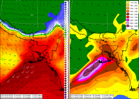
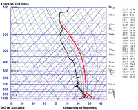
At this time of year a strong westerly jet stream often develops to the south of the Himalayas. Low pressure across the region, especially around Bangladesh, draws extremely moist air northwards from the Bay of Bengal, whilst dry air from the higher ground to the west advects eastwards over the moist air - an 'elevated mixed layer', or EML. This creates extreme instability in the area, although it can also be strongly capped (meaning no storms). The combination of extreme instability and strong vertical wind shear mean that supercells can develop, and often produce giant hail and sometimes tornadoes, as well as strong 'straight line' winds. These charts from the ECMWF model show that the current situation has fairly strong winds aloft (right hand chart, the wind barbs show 35-40 knot westerly winds at the 500 mb level), extreme instability (CAPE values of over 4000 J/Kg), moist air (lef chart, the shading shows surface dewpoints of 23-24C) - the left chart also shows the surface flow, with the wind barbs showing northwards advection of the moist air.
A strong westerly jet is indicated to continue for the next 10 days - minor perturbations in the flow, as well as low-level forcing mechanisms which are not well understood should allow the development of supercells at times, with an attendant risk of severe weather including tornadoes.
A strong westerly jet is indicated to continue for the next 10 days - minor perturbations in the flow, as well as low-level forcing mechanisms which are not well understood should allow the development of supercells at times, with an attendant risk of severe weather including tornadoes.