• A friendly and periodic reminder of the rules we use for fostering high SNR and quality conversation and interaction at Stormtrack: Forum rules

    P.S. - Nothing specific happened to prompt this message! No one is in trouble, there are no flame wars in effect, nor any inappropriate conversation ongoing. This is being posted sitewide as a casual refresher.

Question: Is this an Example of Sidelobe Contamination?

gdlewen

EF2
Joined
May 5, 2019
Messages
195
Location
Owasso, OK
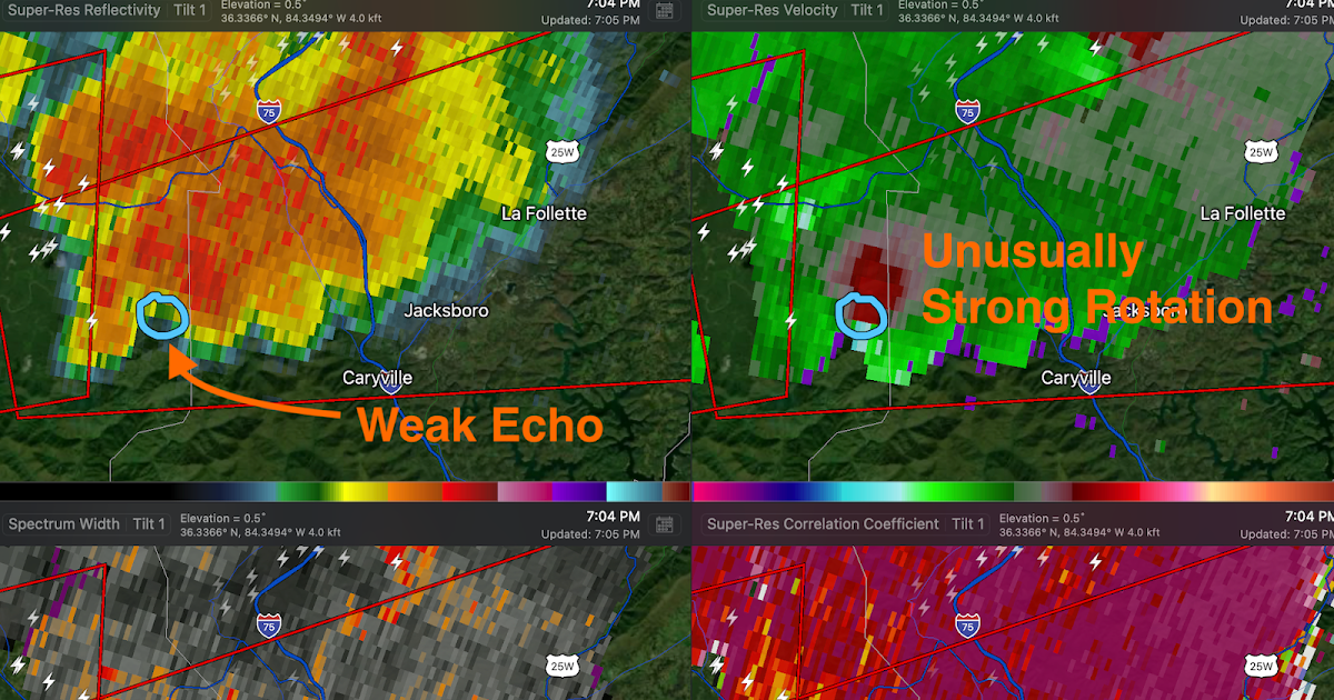
On June 9, 2023 at 8PM CST the Tulsa radar sampled a cell very close to the radar site (about 9 miles distant). The four-panel display below shows what looks like a velocity couplet (albeit very noisy) distinctly separate from the higher reflectivity portion of the storm. At this distance, the beam is only at an elevation of about 1600 feet, but RadarScope only offers the bottom 4 elevations, so I can't check to see what is going on at higher elevations.

My first thought was, "Sidelobe contamination", but given that the distance to the radar is only about 9 miles, I wonder how much "contamination" is possible from the sidelobes, which should still be very close to the main beam at this distance. And if it is contamination, can we assume the sidelobe is sampling a region of rotation above the 4th elevation offered by RadarScope?

Any thoughts?

KINX_20230610_0101Zx4.png
 
The RhoHV <0.9 and spurious velocity scatters are definitely non-meteorological. It looks to me like a clutter mitigation false alarm and/or azimuthal sidelobe.
 
While I'm unable to answer your specific question, I just wanted to point out something I recently discovered. My android version of Radarscope has a separate table of level 2 products that offer quite a few scan elevations that are higher than the lowest 4 tilts. It must've been a recent addition during one of the last couple of updates, because I don't recall those being an option before. The highest tilt for reflectivity and velocity are tilt 12, at 6.4°.
 
While I'm unable to answer your specific question, I just wanted to point out something I recently discovered. My android version of Radarscope has a separate table of level 2 products that offer quite a few scan elevations that are higher than the lowest 4 tilts. It must've been a recent addition during one of the last couple of updates, because I don't recall those being an option before. The highest tilt for reflectivity and velocity are tilt 12, at 6.4°.

Really good to know--thank you. I'm looking at my account settings right now, but they are Mac-based products (iPhone, MacBook), and I am not seeing anything obvious. Definitely worth exhaustive investigation, though.

I did use Weather & Climate Toolkit to check higher elevations in Level 2 data and there were several elevations with strong returns above the anomalous region, so contamination could be the culprit. I think this is the first time I have ever really missed higher scan elevations in RadarScope....
 
The RhoHV <0.9 and spurious velocity scatters are definitely non-meteorological. It looks to me like a clutter mitigation false alarm and/or azimuthal sidelobe.
Thanks very much for the quick reply. The speckle pattern in the velocity data and corresponding low CC were what tipped me off. Plus the lack of spatial and temporal continuity: the SRV and CC (RhoHV) "anomaly" was really not evident for more than a couple of volume scans nor really evident at lower elevations.

But--I was really not familiar with the sophistication of the clutter mitigation algorithms employed until your comment caused me to check it out. Thank you! It's a fascinating topic.

The clutter mitigation algorithms are only the start with NEXRAD... There are tons to learn about all the processes going on with all of them, especially when you get to how they filter specific stuff out like second trip echoes through SZ-2 Phase Coding... The nomenclature is immense, hah.
 
Sidelobes seem to be an increasing issue in generating "false alarm" tornado warnings.
*snip*

Thanks very much. The paper linked in your post was extremely helpful—and very accessible to non-meteorologists, which is always a plus.

Based on those readings, and not being able to explain how a failure in clutter mitigation could create those signatures, I am going with “sidelobe contamination.”

Appreciate all the comments—very instructive!
 
@gdlewen - Just wanted to mention that I noticed today that there were higher tilts available than what I previously stated. I'm wondering if what's available is related to the VCP, because while I was watching that storm in C Texas just now, I noticed the highest scan was tilt 19 at 19.5°. If you don't have a separate Level2 table, it must be specific to Android devices, and hopefully it'll be added for Apple products in a future update.
 

Attachments

  • Screenshot_20230612-193523_RadarScope.jpg
    Screenshot_20230612-193523_RadarScope.jpg
    65.3 KB · Views: 0
@gdlewen - Just wanted to mention that I noticed today that there were higher tilts available than what I previously stated. I'm wondering if what's available is related to the VCP, because while I was watching that storm in C Texas just now, I noticed the highest scan was tilt 19 at 19.5°. If you don't have a separate Level2 table, it must be specific to Android devices, and hopefully it'll be added for Apple products in a future update.
Yeah--I don't see anything like that in my app, so I think you are right and it is specific to Android--I might ask the folks that put out Radarscope if they have any plans to roll it out for iPhones. But for now, I shift over to the Weather and Climate Toolkit (WCT) to view the other angles.

I wasn't going to bring this up, but now that I'm on the subject of WCT, I used WCT to confirm there was a decent vertical gradient in reflectivity adjacent to the location of the artifact that prompted the original post. That is consistent with what @Mike Smith posted (including the journal paper linked therein) to look for when assessing suspect rotation. Not a WER per se', as one would find in a supercell, but a a high-Z "overhang". All very consistent, now that I understand it better.
 
Back
Top