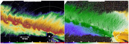
Low top supercell convective snow squall

Just wanted to clarify - you realize that a storm has to be rotating in order to be a supercell? Being low-topped and with good structure is not enough, it must have persistent rotation.

And that's the key.

It's just like spotting a tornado. You can have low scud features, inflow features that resemble a tornado, but if it's not rotating, it's not a tornado.

A supercell has to be treated the same way.

For this particular instance, there would have to be concrete confirmation of not just rotation, but persistent rotation - in this snowshower to be classified a supercell. Otherwise, it's just a darn good looking convective-type snowshower.

Love the pic, regardless of it's meteorological classification.
 
Almost for sure, low top supercell convective snow squalls due occur in Michigan and other great lake states.

There is no doubt that the proper ingredients such as moisture, shear and CAPE would be in place during the cold season near the lakes. The lakes can generate tremedous CAPE from heat/moisture coming off the lakes and very steep lapse rates. (Just take a look at BUFKIT soundings during the late Fall. 1500-2000 lake induced CAPE values happen) Proper shear is more difficult to obtain because it would tend to spread available moisture out too much and weaken convection. Also adequate shear would generally cause lake induced convection to quickly move away from its source of heat/moisture so persistence requiements of a supercell wouldn't be met.

I can think of at least one situation where something like this would mostly likely occur.

Consider Lake Superior and the North shore of the Upper Pennisula which runs basically in a West to East Fashion. NW winds coming off Lake Superior..supply a continous supply of the required heat and moisture...and a West to East boundary that exists inland from the Lake caused either by a lake breeze or some other type of localized convergence..could create a persistent low topped supercell moving along the boundary.

Is there an example of this? Per "Michigan Weather" by Richard A. Keen...in 1987. "A lake-effect "snowburst" dumps 27.5" of snow on Munising on April 1-2, burying cars in 6-foot drifts. Less than 40 miles away at Grand Marais, only 1" of snow falls. As the storm gears up on the afternoon of the 1st, a brief tornado drops out of a snow squall and damages a mobile home on the south shore of Whitefish Bay".

Couple of things to note about this. The tornado is at least suggestive of a supercell. I don't think that this tornado would have been of the waterspout variety as Whitefish Bay would have likely still been completely froze over on April 1 and the South shore is at least 25 miles from Lake Superior. Munising and Grand Marias are in a line West of Whitefish Bay. Another likely necessary ingredient..no snow on the ground. Afternoon heating on bare ground would definately help the cause for more scattered/intense convection.
 
Last edited by a moderator:
Setting aside labeling for a bit, my understanding is that there is a basic underlying mechanism in question. That is where the downdraft associated with precipitation from a Cb is laterally displaced due to vertical shear enough so that it doesn't cut off the updraft feeding the cell. With or without directional shear IMO this mechanism is sufficient to perpetuate something that looks and acts like a single cell.

Now the downdraft pool created by liquid precipitation in non-supercellular vertical shear conditions pretty much always (from my amateur observation) eventually chokes off the updraft. However this isn't inevitably the case and what I'd call "training uni-cellular" storms can and do occur. I think the tail-end Mike of some squall lines has these characteristics, for example.

Frozen precipitation doesn't generate a downdraft nearly as intense and cold as liquid precipitation. So I'd suggest that such training uni-cellular storms aren't all that uncommon. I think I've seen them many, many times over the years, including a few years ago on my way from Santa Fe to Albuquerque one winter day. They can and do have enough shear to generate elevated funnels sometimes, but almost never have the right dynamics -- associated with supercells -- to produce a tornado. FWIW.
 
Almost for sure, low top supercell convective snow squalls due occur in Michigan and other great lake states

Any radar examples? I just don't see the ability for a full-fledged supercell with snow. Could there be a little spin in a snow squall? I'd say so. But persistent? Doubter until proven otherwise ;)
 
Is there an example of this? Per "Michigan Weather" by Richard A. Keen...in 1987. "A lake-effect "snowburst" dumps 27.5" of snow on Munising on April 1-2, burying cars in 6-foot drifts. Less than 40 miles away at Grand Marais, only 1" of snow falls. As the storm gears up on the afternoon of the 1st, a brief tornado drops out of a snow squall and damages a mobile home on the south shore of Whitefish Bay".

Couple of things to note about this. The tornado is at least suggestive of a supercell. I don't think that this tornado would have been of the waterspout variety as Whitefish Bay would have likely still been completely froze over on April 1 and the South shore is at least 25 miles from Lake Superior. Munising and Grand Marias are in a line West of Whitefish Bay. Another likely necessary ingredient..no snow on the ground. Afternoon heating on bare ground would definately help the cause for more scattered/intense convection.

There are plenty of tornadoes that can be produced by non-supercell convection. Hell, you can get vorticies in clear air. If you get a tornado touching down along a lake shore when there is such a temperature gradient as to get convective lake effect snow, I sense there is a non-supercellular, non-mesocyclonic entity at work. I must agree with Mr. Dale and remain a skeptic until shown a concrete example.
 
I heard back from the Albuquerque NWS office:

As it turns out, my family and I were returning from Red River this past Sunday afternoon and witnessed several well-developed convective bands of mixed IP/SHSN just south of Taos, and then along North 14 between Madrid and Sandia Park. What struck me most was moderately strong outflow (enough to shake the Explorer) and a visually striking shelf-like cloud structure on the cells just east side of the Sandias. I snapped a pic on my cell phone, but it did not come out very good. The convection from my perspective was indeed shallow/squatty but well-developed. I did hear a few rumbles of thunder between 530-600pm. Hardly a low topped supercell.

Responses from other staff members also corresponds more toward low topped convection/convective snow bands in a shear environment but not supercellular.​
 
Any radar examples? I just don't see the ability for a full-fledged supercell with snow. Could there be a little spin in a snow squall? I'd say so. But persistent? Doubter until proven otherwise ;)

That sounds likes a challenge! :) I will keep my eyes open for an example going forward.

Looking at this paper on waterspouts..it classifies waterspouts as being "tornadic" when the convective cloud depths exceeds 25,000 feet or so. I believe the author means supercelluar tornadoes are possible with cloud depths of that height along with the cooresponding temperature difference between the lake and water. http://www.essl.org/ECSS/2007/abs/07-Climatology/1178114308.keul-1-sec07.oral.pdf

That might be a little tough to meet except perhaps during the Fall..of course..then you might have the problem that our SP Supercell ( :) ) might actually be producing rain instead of snow!
 
I live on the coast of Lake Erie, where we get some pretty spectacular winter convection from time to time. Thunder snow/sleet is not uncommon here. I've always wondered about something like this, and this is how I've got it figured from my limited forecasting experience.

Convection can occur at any temperature, you only need an appropriately strong vertical temperature gradient. For a supercell, besides that convection, you need moisture (a problem in winter but not impossible. Lake effect, for instance) and a properly sheared wind field. If any of you guys have ever looked at a really wicked winter storm, the hodographs are often some of the most beautiful and deep curves I've ever seen, so I would think that's also possible. There are lots of other variables, but those are the big ones, so just for argument's sake, lets say it is theoretically possible.

My one big question is, given the fairly vigorous nature of the updraft in a supercell, even if the entire storm existed in a below-freezing environment, would it really be snow? I would almost think that the updraft would result in sleet or some other form of heavier precip, though I suppose if some of the precip formation happened closer to the top of the storm, it might not be quite so nasty an environment for a delicate snow fake, and could result in some snow/sleet/hail mix.

I've seen some pretty spectacular thunderstorms producing copious amounts of sleet, complete with CG and a gust front. What says it couldn't rotate in the right wind fields?

As an interesting side note, in December we had a pretty nasty winter storm come through. It went from the high 40s to the low 30s in less than 2 hours. A tornadic supercell fired on the leading edge of the cold front, just inside the warm sector, followed closely by a *violent* squall line that produced hail, sleet, and rain, along with tons of lightning and winds approaching 70mph. In the cold pool below the squall line, temps dropped into the low 40s/high 30s almost instantly. Pretty spectacular cold core sort of setup ;)
 
Last edited by a moderator:
I live on the coast of Lake Erie, where we get some pretty spectacular winter convection from time to time. Thunder snow/sleet is not uncommon here. I've always wondered about something like this, and this is how I've got it figured from my limited forecasting experience.

Convection can occur at any temperature, you only need an appropriately strong vertical temperature gradient. For a supercell, besides that convection, you need moisture (a problem in winter but not impossible. Lake effect, for instance) and a properly sheared wind field. If any of you guys have ever looked at a really wicked winter storm, the hodographs are often some of the most beautiful and deep curves I've ever seen, so I would think that's also possible. There are lots of other variables, but those are the big ones, so just for argument's sake, lets say it is theoretically possible.

My one big question is, given the fairly vigorous nature of the updraft in a supercell, even if the entire storm existed in a below-freezing environment, would it really be snow? I would almost think that the updraft would result in sleet or some other form of heavier precip, though I suppose if some of the precip formation happened closer to the top of the storm, it might not be quite so nasty an environment for a delicate snow fake, and could result in some snow/sleet/hail mix.

I've seen some pretty spectacular thunderstorms producing copious amounts of sleet, complete with CG and a gust front. What says it couldn't rotate in the right wind fields?

As an interesting side note, in December we had a pretty nasty winter storm come through. It went from the high 40s to the low 30s in less than 2 hours. A tornadic supercell fired on the leading edge of the cold front, just inside the warm sector, followed closely by a *violent* squall line that produced hail, sleet, and rain, along with tons of lightning and winds approaching 70mph. In the cold pool below the squall line, temps dropped into the low 40s/high 30s almost instantly. Pretty spectacular cold core sort of setup ;)

I think when you are talking about "sleet" in regards to lake-effect..I think you are really talking about "graupel".

In the Fall, almost all the convective type snowshower activity I see includes at least some graupel if you look closely enough..and at times 100% graupel.(Graupel forms in supersaturated cold air near -13C..exactly what you have from lake induced convection.) - It wouldn't surprise me that anything convective enough in a cold pattern that it approachs supercellular characteristics-it would consist almost entirely of graupel.
 
Last edited by a moderator:
Here is a link to some photos of some impressive Winter type convection in Britian with snow being the primary form of precip..complete with well defined anvils and even some good mammatus clouds! The link includes radar images of a convective snowshower that containing severe/damaging hail/high winds.(that particular cell..concluded with heavy freezing rain.)

http://www.eots.co.uk/reports/Xmassnow/Xmassnow2004.htm
 
Last edited by a moderator:
I think the recent event near Tinian, NM (discussed in a recent thread in the Weather in the News section) is relevant to this discussion from some years ago. I know the majority opinion is that this tornado associated with a snow squall was a landspout, not a mesocyclone tornado, but looking at the video and seeing the tornado clearly separated from a nearby precipitation shaft, I am not so sure. And regardless, it certainly shows you can get rotation, and even a tornado, with a New Mexico snow squall.

 
Here in the UK, it's possible to get 'low-topped' supercells in cold airmasses in strongly sheared environments. I certainly know of examples whereby the air temperatures were only around 6-7C or so. Regarding snow, though, it's harder to think of an example. It's possible to have such a storm which produces intense precip and lowers the wet bulb freezing level enough to get snow to fall to ground level, I think - but to have one which *only* produces snow would be a bit of a tall order - at least in the environments I'm thinking of over here.
 
Almost for sure, low top supercell convective snow squalls due occur in Michigan and other great lake states.

There is no doubt that the proper ingredients such as moisture, shear and CAPE would be in place during the cold season near the lakes. The lakes can generate tremedous CAPE from heat/moisture coming off the lakes and very steep lapse rates. (Just take a look at BUFKIT soundings during the late Fall. 1500-2000 lake induced CAPE values happen) Proper shear is more difficult to obtain because it would tend to spread available moisture out too much and weaken convection. Also adequate shear would generally cause lake induced convection to quickly move away from its source of heat/moisture so persistence requiements of a supercell wouldn't be met.

I can think of at least one situation where something like this would mostly likely occur.

Consider Lake Superior and the North shore of the Upper Pennisula which runs basically in a West to East Fashion. NW winds coming off Lake Superior..supply a continous supply of the required heat and moisture...and a West to East boundary that exists inland from the Lake caused either by a lake breeze or some other type of localized convergence..could create a persistent low topped supercell moving along the boundary.

Is there an example of this? Per "Michigan Weather" by Richard A. Keen...in 1987. "A lake-effect "snowburst" dumps 27.5" of snow on Munising on April 1-2, burying cars in 6-foot drifts. Less than 40 miles away at Grand Marais, only 1" of snow falls. As the storm gears up on the afternoon of the 1st, a brief tornado drops out of a snow squall and damages a mobile home on the south shore of Whitefish Bay".

Couple of things to note about this. The tornado is at least suggestive of a supercell. I don't think that this tornado would have been of the waterspout variety as Whitefish Bay would have likely still been completely froze over on April 1 and the South shore is at least 25 miles from Lake Superior. Munising and Grand Marias are in a line West of Whitefish Bay. Another likely necessary ingredient..no snow on the ground. Afternoon heating on bare ground would definately help the cause for more scattered/intense convection.
Living in Michigan I may be a bit biased, but I see where Mike is coming from, as the ingredients can be there fairly often during the cold season. However, I think it’s more likely that mesolow moved off of the lake and an intense feeder band followed, sitting over Munising for hours on end. Scenarios like this can produce 3-5 in/hr snows, and I saw similar setups a few times last winter over Lake Superior, Michigan, and Huron.

The winter weather in Michigan is definitely some of the most difficult to forecast considering the lakes affect/amplify most storms that come through. I still think a snow-producing supercell could form, but it’d have to be a winter extreme.
 
Back
Top