Brian McWatters
EF0
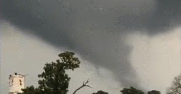
On Wednesday at 16:45 CDT there was an EF-2 tornado in Bryan, Texas. The tornado was unusual in that it was produced by a low topped supercell. I found a monograph about this type of supercell here: Mini Supercell Thunderstorms
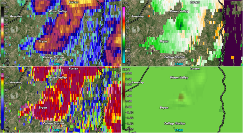
The radar screenshot below (from 16:40 CDT) shows the supercell that produced the tornado; the arrow points to it. It formed in advance of a fast moving MCS (squall line). It is clearly smaller and less intense than a typical supercell. Shortly after the tornado I was watching a meterologist on KBTX-TV who said the top of the cell as indicated by radar was no more than 20,000 feet. Also low topped supercells are known to form when instability is weak to moderate, which was the case Wednesday because CAPE was close to 1000 according to the SPC: Storm Prediction Center Mesoscale Discussion 435
The tornado happened without warning. There were no watches or warnings of any kind in effect for Bryan when the tornado occurred. But as stated in the monograph, low topped supercell attributes are more difficult to discern by radar at long ranges. The closest NWS radar was 70 miles away from the tornado.