Mike Smith
EF5
I'm a little surprised someone else hasn't started a thread for Wednesday and Wednesday night, but here goes.
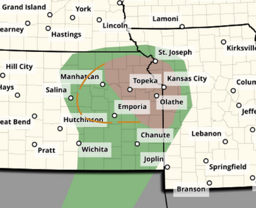
Attached is my tornado forecast for Wednesday from 5pm until 2am Thursday. Please note the brown dashed lines -- which are my addition to the 5% area -- an area which may have to be increased tomorrow morning.
Pressures are forecast to fall significantly during the day tomorrow as shown by the 12Z ECMWF, 18Z HRRR and 18Z 3km NAM with a low in the Pratt-Alva area by ~5pm with pressures as low as 998mb. A warm front from the low to near Marion to between Ft. Scott and Olathe. Td's will be around 60 in the area of interest (Td's are 63°F as far north at KCLL at 4pm and they will move north tonight and Wednesday morning).
Normal Pw for this time of March in eastern Kansas is around .55 inches. It will likely be above normal by ~1/10th inch tomorrow evening, which is favorable climatologically.
The "best" factor is the shortwave trough forecast to be negatively tilted from KGJT to KROW as of 3pm CDT. It will move across the threat area as the polar front jet stream pokes its left front exit region into south central Kansas. The lift from the jet, 700mb WAA, the PVA may bring the severe thunderstorm and tornado threat farther southwest than SPC is currently forecasting.
I am unable to chase tomorrow, but if I were, I would want to be somewhere between Newton - McPherson - Strong City by 1pm and adjust from there. [Please note: K-4 is closed from White City to Alta Vista. ] West of the Flint Hills, this is excellent chasing territory with good roads and good visibility.
I think there is a chance of severe thunderstorms and, perhaps, a tornado past midnight due to the strong jet difluence and short wave.
Be safe and good luck tomorrow.
Attachments
Last edited: