Landspout or Gust Tornado ?

Damien49

EF0
Joined
Mar 26, 2012
Messages
31
Location
France, near Nantes-Angers (Loire Valley)
Outflow Boundary Tornado : Hybrid landspout-gustnado ?

Hello,

I am a French storm tracker and April 30, 2007, I was confronted with a strange tornado. I know it is a no-mesocyclone tornado (EF0) that developed in front (or long) a shelf cloud. But precisely what kind of tornado ? Is it a landspout, a gust tornado or other ?
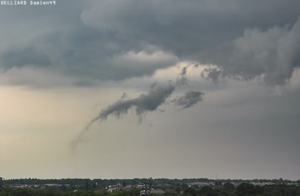
9551adb1b1974cd1a71ff8c348482629.png

You can find more photos of the tornado here : http://www.meteobell.com/__orage_070430_3.php
and the shelf cloud : http://www.meteobell.com/__orage_070430_4.php

Thank you very much. It is very difficult in France to find a clear explanation.


Sorry if this is the wrong section I do not speak English very well, but I'm looking for detailed technical information.
 
Last edited by a moderator:
That's really, really neat. Was there a debris cloud at the surface? It looks like there might be a faint column of dust extending from the ground in that picture. I did a contrast enhance on the image, but I'm not seeing much of a pronounced debris cloud and the dusty portions above the ground might be part of the "scud" of the feature. I'd say this is probably a landspout if there was a debris cloud at the surface, and the shape is due to the outflow pushing it forward. I've seen images of spouts including waterspouts in a similar configuration, where the storm's outflow makes it bow out in front of the storm. There's probably some vorticity along that gust front that the updraft is stretching to produce the spout. The disjointed and scuddy appearance of the funnel above is also really interesting. I think this might be the result of the circulation being relatively weak and the outflow having a heavy influence in it's formation. Nice catch! One for the spotter classes.
 
Was there a debris cloud at the surface?

Yes it is. Witnesses nearest reported seeing this tornado touch the ground. In the links I set, you will see more pictures, at other times

Example 3 minutes after:
070430_20h41_tornade1.png


Are there several different types of landspout? what category it would rank? wikipedia is very empty : http://en.wikipedia.org/wiki/Landspout
 
Last edited by a moderator:
I looked at the images on the site and am not seeing much of a debris cloud in any of them. That one above shows some scud very close to the ground, but even scud condensing right off the ground is not enough to make it a tornado. You'd need to have a tight, violently rotating circulation on the ground. If other people documented that debris cloud, that would definitely confirm it as a tornado, but if they simply saw the same scud clouds close to the ground, I think this might be just an outflow feature like a scuddy tendril forming along the storm's gust front.

Spouts, whether they form over land or water, are generally formed under the same processes. There is usually some vorticity at the surface along a boundary that is stretched by an updraft to produce a tornado. They lack the parent storm structure of a supercellular tornado, but supercells do produce spouts as well. As you probably know, another feature that's common along gustfront and shelf clouds is the gustnado, where you get a tight circulation on the ground, but no corresponding funnel or rotation above in the storm's base. They're not tornadoes as result. I was leaning on spout in your image because that tendril does look like a scuddy funnel.
 
While I was writing the following, others beat me to the punch. I haven't yet looked at what they've written, but I'm not going to rewrite my own response. For better or worse, here it is:

Now that is just plain fascinating. It's certainly not a mesocyclone tornado, but I don't think it fits neatly into the category of either a landspout or a gustnado; it almost seems like a hybrid of the two. Its proximity to the gust front is suggestive of a gustnado; but its connection with the end of the arcus via a condensation tube shows it to clearly be more than just a surface dust whirl.

I'm hardly the most experienced chaser on this forum, but I've seen arcus clouds beyond count and plenty of gustnadoes, and I've never seen anything like that. Your cautious observation of it lends credibility to your conclusion that it was tornadic. I can speculate that it involves vorticity that got tilted upward along the gust front. Beyond that, I'll just say that it's the second unusual vortex that someone has posted about here in the last couple of months, and it's pretty neat!
 
I understand your caution to call it a tornado. In France too, this case is very original. This is why I come to see you. I was about 5km. But several witnesses complementary, well confirmed the rotary outgrowth cloud on site. Several people have even confirmed that a "bush" (I d'ont know if in english, bush is the right name) was visible to the ground "surrounding vegetation was agitated, and this long before the arrival of the gust front, itself."

In fact, for 6 years I'm looking for answers, now the question is not really whether or not to hit the ground, we affirm Yes (National Observatory of thunderstorms, also assert). The question is if it touches the ground, why and how to nominate this type of tornado.

In any case thank you for your interest and your analysis.

EDIT : Yes the storm was not a supercell I think (but we have no doppler here), but probably a severe storm multicell.
 
Last edited by a moderator:
I'd have to side with Bob that this is probably a hybrid tornado then. The circulation at the ground at the ground may be forming in a similar fashion to a gustnado, but it's also being stretched by the updraft in the shelf cloud. If you're searching for a label to stick on it, I would just stay at Non-supercellular tornado or gustnado/landspout hybrid.
 
In French, I personally called it "une tornade de front de rafale", which could translate into English in as "tornado boundary outflow" or "tornado gust fronts" but it is a personal name because there is no other similar case listed in France. I like Gustnado-Landspout hybrid.

Do you have any links listing similar cases in USA or anything that can explain this?

Anyway Thanks.
 
Last edited by a moderator:
Very different storms right, but they are similar in that they both occurred on the leading edge of a gust front, be it forward flanking as in your case, or from the rear flanking downdraft of a supercell as in Kansas in '08. The wall cloud was bowing out at that time and taking on many of the characteristics of a shelf cloud. Most of the storms in Kansas lined out a short time later too. Some similar mechanics are probably at work. I think Bison was more of a supercellular tornado that was being heavily influenced by outflow, while yours was probably more of a landspout (or gustnado) that was being heavily influenced by outflow if that's where the main difference is. Similar in that they may be gustnado like hybrids due to the influence from the gust front.
 
Back
Top